

bkviking
-
Posts
729 -
Joined
-
Last visited
Content Type
Profiles
Blogs
Forums
American Weather
Media Demo
Store
Gallery
Everything posted by bkviking
-
November 2023 temperature forecast contest
bkviking replied to Roger Smith's topic in Weather Forecasting and Discussion
DCA: -0.1 NYC: -0.2 BOS: -0.4 ORD: -0.1 ATL: -0.3 IAH: -0.2 DEN: +0.2 PHX: +1.0 SEA: +0.2 -
Wow Chris - you are no longer on LI I see! Still, New Haven is really just a stones throw from my ole hometown of Shoreham on opposite side of Sound. Btw, Original Pepe’s is better than Sally’s to me Lol . Ok - well we will just have your detailed weather observations from a little further north and east. I hope new location offers less changeovers for you with a bit more latitude than SW Nassau screw zone you come from.
-
September 2023 temperature forecast contest
bkviking replied to Roger Smith's topic in Weather Forecasting and Discussion
DCA: +2.1 NYC: +2.5 BOS: +2.4 ORD: +2.8 ATL: +2.7 IAH: +2.0 DEN: +1.9 PHX: +2.0 SEA: 0.3 -
Eric Webb on the “beastly east pacific Nino” - have to follow the whole thread.
-
August 2023 temperature forecast contest
bkviking replied to Roger Smith's topic in Weather Forecasting and Discussion
DCA +1.4 NYC +1.4 BOS +1.5 ORD + 0.8 ATL +1.0 IAH +2.4 DEN +2.4 PHX 2.5 SEA +2.2 -
In Smithtown I had a low of 56°. It has to be years since it was this cool in midsummer around here.
-
92/75/104 in Smithtown.
-
90/78/105 in Smithtown
-
Same here up the block from you here in Smithtown. 64° DewPoint to go with that as good as we’ve had it this summer.
-
Moderate then downpour in past half hours in Port Jefferson on north shore. This place has been hit often lately - at least 4x in past week.
-
1.61” for day here in Smithtown, LI on north shore and it looks by and large over. Just east/southeast of here got the huge totals but still impressive.
-
1.33” here in Smithtown.
-
Heavy rain persisting here in Port Jefferson, LI.
-
In Smithtown I show a 96° - I have to think that’s more anomalous but PSV and CFA who are somewhat local to me in 90’s corroborates at least 90. See if Ed in Smithtown posts on this one.
-
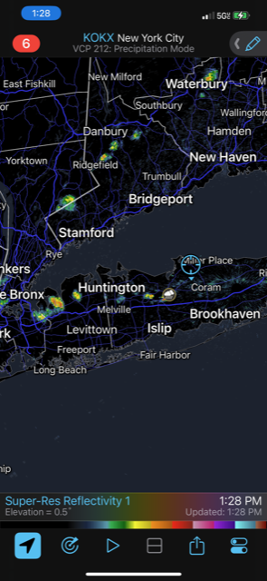
Storms appear to be firing across LI near sea breeze boundary just north of LIE (blue line across LI)
-
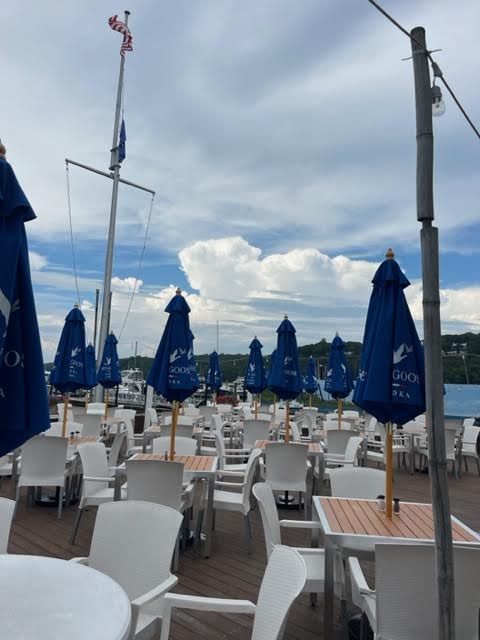
Port Jefferson - looking northeast from Danfords. Sad - restaurant is empty due to this crappy rain day - we had a bunch of annoying showers here today. Can’t make up for this now - they lost a day of business. This area has been hit with a lot of these annoying showers lately. El Niño summer sucks.
-
It does finally look good for you.
-
Been crappy in Port Jefferson area. Non stop off and on showers. The one thing I didn’t like about the incoming Nino was this kind of crap seems to happen during Nino summers. 2009 was a nightmare. During this whole period from days before solstice to now - rarely a sunny day to have a nice sunset , especially when they’re at their latest. Just wasted. Losing a minute per day now.
-
86°F / 76°DP. Smithtown. Really first real swamp day of the season.
-
In Smithtown and I’m already .39” with another isolated shower possibly about to scrape me.
-
July 2023 temperature forecast contest
bkviking replied to Roger Smith's topic in Weather Forecasting and Discussion
DCA +1.0 NYC +0.9 BOS +0.9 ORD +1.1 ATL +0.9 IAH +2.0 DEN +2.2 PHX 2.2 SEA +1.4 -
Several of those years stick out as El Niño years. Is that majority ?
-
We are well within range and live a few blocks from one another - so your reading corroborates with mine pretty well. Healthy drink today so I won’t be watering the herbs and plants . Lol
-
Smithtown LI - my weather station shows .62” from storms today. I’m out east in Port Jefferson and storms keep forming and cutting a little west of me here (into Setauket). Another one on way now. I know family has heavy rain further east into Shoreham area also a short while ago.
-
In Smithtown, LI I have .41” for the day today with that batch of showers that came through around noon. Add .06” yesterday.

