
marsman
-
Posts
717 -
Joined
-
Last visited
Content Type
Profiles
Blogs
Forums
American Weather
Media Demo
Store
Gallery
Everything posted by marsman
-
Is the Cliff Diving thread only for lack of snow? Or any lack of precip? UPDATED below!
-
Comfortable morning. 68 for a low at 1:13am. Opened the windows, then that sun came out and it got intense. 87 at 3:15pm. Hoping the TC in the Gulf will help at the end of the week, but "signs point to no."
-
High of 99 at 3:09pm. We're in the same stranded boat but I can't help but laugh at this point, there's nothing else to do.

-
Goose eggs here from those storms yesterday. Watering my garden & lawn, so it will pour tonight. Overnight low of 72.
-
101 at 4:26pm. Had about 5 raindrops hit my car driving past the State Fairgrounds.
-

-
104 at 5:43pm.
-
102 at 1:42pm. For those of you in Raleigh and east, enjoy the rain.
-
Yesterday had about 10 raindrops hit my windshield on the way home, 98 for a high. Currently 101 today.
-
High: 96 on 5/19 Low: 40 on 5/2 2.62" for the month.
-
Down on the coast, mostly sunny and 80 with a heat index of 86 in Carteret County NC.
-
95 at 4:46pm. I still say 50% chance of .50" of rain.
-
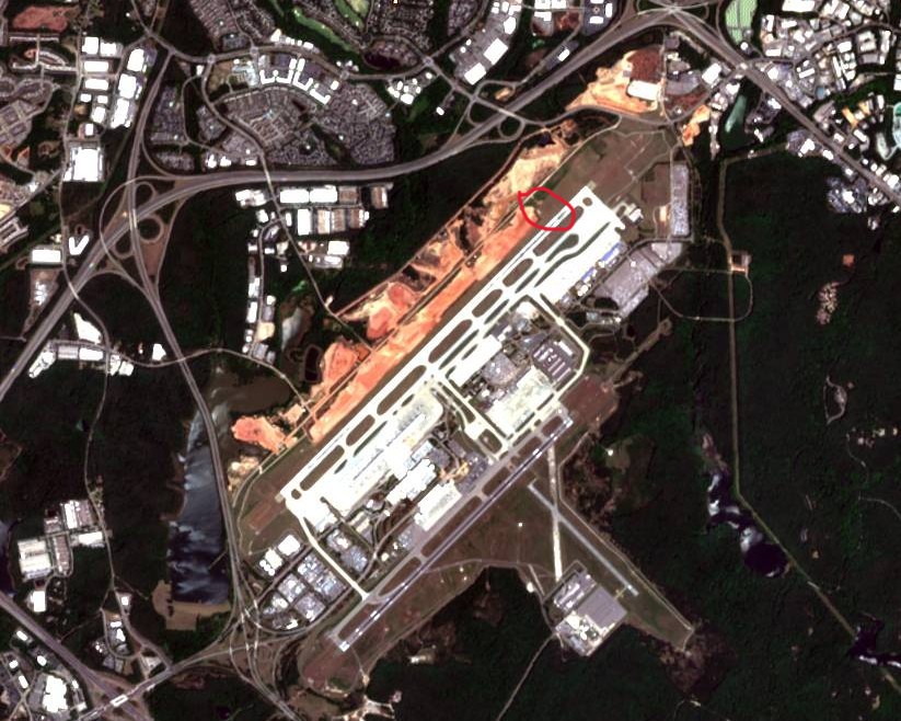
Speaking of RDU, the station is right smack in the middle of the new runway construction. Does anyone know where it's going to go?
-
68 at 6:07am, 96 at 5:54pm.
-
This is great, and will save our lawn and gardens. I wish it wasn't Memorial Day weekend. Figures. That said, there is no bad grilling weather. Only bad equipment.
-
65 at 5:27am, 94 at 4:03pm.
-
Low of 45 at 6:15am, high of 80 at 5:35pm.
-
Low of 42 at 5:43am.
-
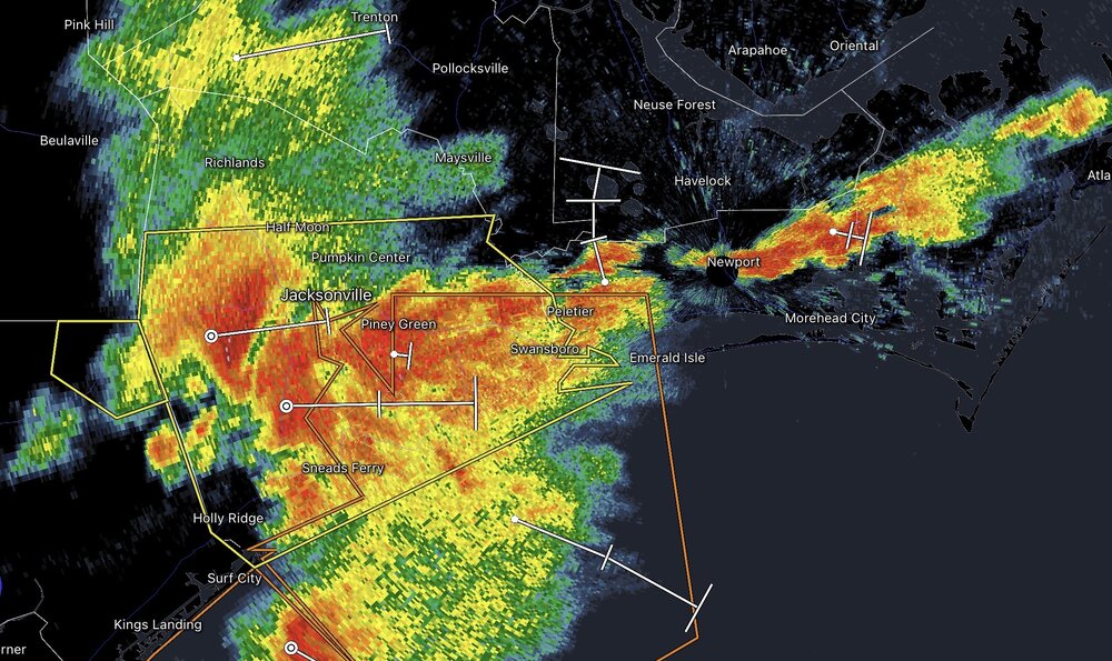
Gnarly line coming through Jacksonville, NC
-
Low of 40 at 5:37am, High of 71 at 5:34pm. Great afternoon/evening for windows open.
-
.20" for the day and a high of 57 at 4:14pm. Thinking about running the fireplace one more time, I can tell from the air others have been running theirs.
-
We got June weather in April and now we have March weather in May. Chilly 54 and light rain.
-
High of 95 on 4/17, low of 35 on 4/8. 1.74"
-
Well I have to eat my words - a very quick .23" last night. Edit: after a brief high of 77 at 4:52pm, temp dropping quickly, down to 69 now at 6:40pm.
-
77 at 6:23pm, warmer than expected. Wunderground still showing 99% chance of rain tonight.