

2001kx
-
Posts
2,260 -
Joined
-
Last visited
Content Type
Profiles
Blogs
Forums
American Weather
Media Demo
Store
Gallery
Everything posted by 2001kx
-

Central PA - Jan/Feb 2019 Obs and Discussion
2001kx replied to MAG5035's topic in Upstate New York/Pennsylvania
Also im at 28 degrees -
Central PA - Jan/Feb 2019 Obs and Discussion
2001kx replied to MAG5035's topic in Upstate New York/Pennsylvania
3.7" as of 9:20pm -
Central PA - Jan/Feb 2019 Obs and Discussion
2001kx replied to MAG5035's topic in Upstate New York/Pennsylvania
thanks MAG. Snow has picked up and i have 1.1" so far. -
Central PA - Jan/Feb 2019 Obs and Discussion
2001kx replied to MAG5035's topic in Upstate New York/Pennsylvania
Sounds good..how long do u think we have up here till the pingers? -
Central PA - Jan/Feb 2019 Obs and Discussion
2001kx replied to MAG5035's topic in Upstate New York/Pennsylvania
Flurries here at best -
Central PA - Jan/Feb 2019 Obs and Discussion
2001kx replied to MAG5035's topic in Upstate New York/Pennsylvania
ughh The surface low is over western TN as of mid morning. It will track toward SWRN PA by late evening before redeveloping further east somewhere over the Mid Atlantic states anywhere from SERN PA to the northern DelMarva. This presents precip type issues possibly as far north as a swath from Clearfield to Tioga counties by the wee hours of Sunday morning. The 00Z HREF was colder only bringing the wintry mix as far north as Central Cambria ENE to Montour and Columbia counties. Obviously the exact placement of this transition zone will be all important in determine final snow/ice totals. We will wait for the 12Z model suite to tweak totals one way or another. -
It's snowing but but it's all doom and gloom reading in here today.
-
The first time they mention mixed precip in my point and click forecast. Saturday Snow, mainly after 10am. High near 28. East wind 6 to 8 mph. Chance of precipitation is 100%. New snow accumulation of 3 to 7 inches possible. Saturday Night Snow before 1am, then snow, freezing rain, and sleet. The snow could be heavy at times. Low around 17. East wind 9 to 13 mph, with gusts as high as 20 mph. Chance of precipitation is 100%. New ice accumulation of less than a 0.1 of an inch possible. New snow and sleet accumulation of 7 to 11 inches possible. Sunday Snow showers, freezing rain, and sleet before 7am, then a chance of snow showers. High near 18. Wind chill values as low as -5. Northwest wind around 15 mph, with gusts as high as 28 mph. Chance of precipitation is 80%. New precipitation amounts of less than a tenth of an inch possible.
-
PAZ017>019-024>028-049>053-191200- /O.CON.KCTP.WS.W.0001.190119T1800Z-190120T1800Z/ Clearfield-Northern Centre-Southern Centre-Cambria-Blair- Huntingdon-Mifflin-Juniata-Union-Snyder-Montour-Northumberland- Columbia- Including the cities of DuBois, Clearfield, Philipsburg, State College, Johnstown, Altoona, Huntingdon, Mount Union, Lewistown, Mifflintown, Lewisburg, Selinsgrove, Danville, Sunbury, Shamokin, Bloomsburg, and Berwick 956 PM EST Fri Jan 18 2019 ...WINTER STORM WARNING REMAINS IN EFFECT FROM 1 PM SATURDAY TO 1 PM EST SUNDAY... * WHAT...Heavy snow with some mixed precipitation expected. Total snow accumulations of 8 to 16 inches, with the highest amounts near interstate 80 and the lowest amounts around Johnstown. Ice accumulations will generally be less than a tenth of an inch. * WHERE...Portions of central Pennsylvania. * WHEN...Snow will develop during Saturday afternoon and become heavy at times toward evening. Expect the snow to change to mixed precipitation Saturday night across roughly the southern half of the state. The snow or mixed precipitation should taper off around sunrise Sunday. * ADDITIONAL DETAILS...Travel will be very difficult to impossible.
-
thanks...that NAM run sucked here...on the very edge. edit: Guess its not as bad as originally thought.
-
Thats only 80 years or so..not too bad
-
Me too. Saturday Snow, mainly after 10am. High near 27. East wind 6 to 8 mph. Chance of precipitation is 100%. New snow accumulation of 3 to 7 inches possible. Saturday Night Snow. The snow could be heavy at times. Low around 17. East wind 8 to 13 mph becoming north after midnight. Chance of precipitation is 100%. New snow accumulation of 7 to 11 inches possible. Sunday Snow, mainly before 7am, then a slight chance of light snow after 1pm. High near 20. Wind chill values as low as -5. Northwest wind 13 to 17 mph, with gusts as high as 25 mph. Chance of precipitation is 80%.
-
Dt posted his first call
-
Ill take it - lol I live about 1 mile from there.
-
I hope so for a change.. I do accept donations.
-
Do you have a link? All i have is a zoomed out view (full USA)
-
-
Thats what i got as well ( 1.5") but i dont have that much on the ground....yet.
-
The gfs is making me nervous for here..Im right on the gradient.
-
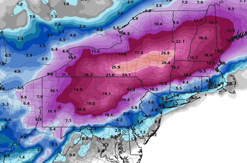
This map does include the snow tonight.
-
If the NAM is right no one will be able to make it..
-
✨Pittsburgh PA ❄ Winter 2018-2019
2001kx replied to north pgh's topic in Upstate New York/Pennsylvania
-
-
Henrys new map
-

