

rjvanals
-
Posts
227 -
Joined
Content Type
Profiles
Blogs
Forums
American Weather
Media Demo
Store
Gallery
Posts posted by rjvanals
-
-
We’ve had some flurries off and on here but needed rates and haven’t had them
-
 1
1
-
-
3K is a definite improvement by holding back the torch at 850 for a few more hours
-
11 minutes ago, AtlanticWx said:
how is it not? you have a strong high north of us damming cold air into the mountains here. this is pretty clearly a CAD signature

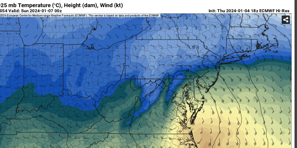
That’s a depressing sight showing the lack of real January cold across the east
-
We're going to have trouble getting better trends if the low goes over Kent Island like the Euro is showing (40 mile swing from its 6z run)
-
1
-
-
The GFS unfortunately has picked up a stronger southerly wind at 850 across the metro the 3k NAM was showing earlier. Hope its wrong
-
3 hours ago, psuhoffman said:
I AM GOING TO BE POSITIVE HERE
So don't miss it, and snow god's don't make me regret it
Something to keep an eye on... I wouldn't expect this per say, but if we are trying to be optimistic I see one thing today that leaves the door open somewhat for a better result NW of 95 here. I am using the 3k NAM but I've noticed the same general trend in the euro its just a couple degrees warmer so not quite as close but going the same way
There has been a trend on the euro and NAM to weaken that inverted trough or trowal feature and allowing the developing coastal to develop a more closed circulation sooner. This cools the column some compared to earlier runs.
If you look close you can see that in the height fields here

The result is the column was VERY close to support snow during the most critical 3 hour period from 95 NW.
This was the 12z run...

That isn't really close in the yellow area. Looking at soundings it was a pretty thick area of close to 2C above freezing in the mid levels.
But look at 18z same time
It's REALLY close to supporting snow. I looked at soundings, 850 is about the warmest layer and its barely above freezing in this region. One more move the same as this and it would be snow in this area.
I didn't cherry pick this hour...it might even be colder the hour before and after if you look.
Before

After

But this is in the middle of a 3 hour period where this area gets .3-.5 qpf.

If it were to be 1 degree colder that would mean a 3-4" thump in this area.
It's possible, not likely but possible, that if this were to be just 1 degree colder than guidance thinks...suddenly if flips the other way in this area.
The 18z Euro tries to do this at hr 54 but has a tiny warm layer just above 850 that screws it up
-
4
-
-
NAM would probably break DCA inch streak at least
-
16 minutes ago, psuhoffman said:
But it's not really cold enough
Below is the mid level thermals heading into the event and I put in purple the bare minimum of where we really want that to be at this point based on case studies of historical similar situations that lead to snow.

Now, for your second part...what COULD have changed this part of the equation.
Had the NS wave to its NW not been there at all and we had a banana high over the top, or if that was weaker I don't know exactly to what degree changes the equation enough but you get the point.
Had the whole thing been faster and the initial NS SW phased partially maybe we get a tighter wound colder system and with that track...that could have worked.
There are little things you could adjust to make this snow. I am NOT saying we can't get snow. It's not all or nothing. There are still ways to overcome warming. I think when we get a legit block soon our chances go way up!
But 2 things can be true. It's also true that if you cool the entire thermal profile about 3-4 degrees F going into this event then DC is most definitely at the least about to end their 1" less snow streak. And frankly the streak wouldn't even exist within that paradigm because there have been several waves during that time where if it was a few degrees colder (F not C) DC would have likely got at least an inch or two.
Euro was the first to pick up on the mid level warmth issue on its Monday night run.
The best runs for the storm showed a Saturday night into Sunday storm w a different setup vs the Saturday storm we have now so who knows if that initial scenario would’ve worked.
-
1 minute ago, SnowenOutThere said:
The real issue with this event has been that since 6z yesterday we’ve seen every cycle wobble just a little warmer. If we can just reverse that trend there’s still some potential …
The surface has been holding pretty steady but the 850 level in particular has been degrading across the past few model cycles to a razors edge at this point
-
12z 3k NAM looks pretty similar to the 12/16/20 storm with a heavy burst of snow initially across the metro area then watched the CC line move steadily NW; wasn't a bad storm here w around 3 inches and dumped ~6 inches in Frederick https://www.washingtonpost.com/weather/2020/12/17/snow-ice-dc-md-va/
-
1
-
-
11 minutes ago, H2O said:
If you are 300'+ and NW of 95 you will do ok. This storm screams 12/5/2009 and for those who remember that one it was a brutal, just brutal gradient from east to west.
For my location just S of DC barely sniffing 200', for the last 5-10 years any storm that has temp issues like this one has erred too cold and its stayed warmer than modeled. UHI, microclimate, whatever. Just won't bode well for storms like this.
Will be lucky to get 1" unless there is a shift in storm track to the SE.
In that storm I went from my parents house in Potomac where we had a plowable snow to Comet Ping Pong in NW where it wasn't much more than a cartopper. 2-17-18 was another one w a sharp gradient from downtown to western suburbs as well.
-
1 minute ago, DarkSharkWX said:
cmc amazing too just NW of dc
Pretty similar idea to the GFS just juiced up a bit
-
The 4pm sounding in DC that’s showing rain is borderline for snow which is the main difference between this and the past two runs
-
06z EPS Mean for 1 inch plus is 82% for DCA which is the highest it's been in the past 4 cycles. The 4 inch mean is holding steady the past few cycles around 30% for DCA.
-
5
-
-
Euro is showing a pronounced warm layer from 850-700 close to the cities in the key 93-96 hr window that the GFS doesn't have. 925 layer is definitely better and 850 is marginally better closer to the cities than the 12z run.
-
1
-
 1
1
-
-
its a good run compared to 18z (has DCA at 32)
-
1
-
-
12 z EPS has 31, 69 for 4,1 inch chances for DC
6 z EPS had 35, 65 for 4,1 inch chances for DC
12 z EPS has 92, 55 for 4,1 inch chances for Germantown
6z EPS had 78, 49 for 4,1 inch changes for Germantown
-
2
-
-
The storm is still 4 days and ~16 model cycles until onset. The final solution isn’t going to be exactly like any of the 12z runs today (for better or worse) so no reason to punt this yet
-
2
-
-
Worth staying up for the Euro (and having an earthquake) but it reminds me a bit of the 12/16/20 storm where 4-5 days out we looked good for significant snow but the mix line quickly punched into the immediate metro. It was still a pretty fun storm with some high initial rates.
-
7 minutes ago, nj2va said:
2 days ago, this threat didn’t pop up on most people’s radars.
@psuhoffmanand a few others honed in on this window around Christmas
-
We need the Low a further south than St. Mary's County for snow in immediate DMV but we could at least all get on the board w this track
-
2
-
-
18z GFS is better for immediate metro
-
1
-
-
1 minute ago, Paleocene said:
Maybe we'll get some flakes on the front end, if the cold air dam is decent? Like that one storm a couple years ago.
Yeah I could see this being like the mid Jan 2022 storm as the cold air is a bit stronger out front on the euro vs it’s 0z run
-
It’s a week out and w the 1/4 system not yet resolved we have room/time for significant changes
-
3
-


January 6-7 Storm Discussion: we’re due?
in Mid Atlantic
Posted
What’s disappointing is we had ~4 hours this morning w a good enough column but no precip ☹️