madwx
-
Posts
2,365 -
Joined
-
Last visited
Content Type
Profiles
Blogs
Forums
American Weather
Media Demo
Store
Gallery
Everything posted by madwx
-
you may remove one spartman but three will come to take his place
-
just actually looked at their profile picture for the first time. yikes
-
Feb 12-14th V-Day Weekend Potential Stuff
madwx replied to Chicago Storm's topic in Lakes/Ohio Valley
NAM is juiced. Definitely taking the under but can see an advisory level snow for S WI and N IL. -
MSN has a similar issue. Shows 5.3" this month when there's only been 3.7"
-
torched all the way up to 10 today after an early low of -18
-
First spring flood outlook comes out on Thursday. Would think they will be hitting the messaging pretty hard, especially for central and southern regions of the sub
-
getting a few drips from melting on dark objects on my deck today. Feb is sun angle szn
-
follows the trends that the end of an arctic outbreak is usually followed by a significant storm
-
with a few more relatively "mild" days today and tomorrow, it looks like colder air filters back in later this week and into the weekend, with Saturday night into Sunday being the coldest timeframe(probably even colder than this past weekend). After that, a slow but steady warming trend looks to occur for next work week bringing us out of this cold snap.
-
Like Cyclone we beat Sunday morning with a -17 here. -31 in Black River Falls and -34 in Merrill and Land O’ Lakes. Some of the coldest spots in Wisconsin
-
rockin shorts on that first above freezing day
-
Only got to 0 for a high yesterday. Getting some flurries now at -3
-
it's all gone downhill since Alek switched his profile pic to the lock
-
for some reason the Euro initializes with 27" of snow depth here even though the official measurement is only 13". The GFS is much more realistic with an estimated 16" snow depth at T-0.
-
lol seems like an unlikely outcome but trends are to a switch to average temps around the start of next week. the models are still honing in on the exact solution but it looks like after the TPV moves over the northern sub next weekend the cold air will start to decay and some pacific air will make it into the region
-
Fort McCoy hit -29 this morning. Black River Falls and Rhinelander got -26
-
-15 here unless we got something lower between 6 and 7
-
-5 here at 11pm
-
Record low temp for tomorrow is -21 set all the way back in 1875. If things tank here overnight we definitely have a chance of getting close
-
Lol lots of anxiety posting here. Above average temps after February 24. You heard it here first
-
>no snow on the ground >beavis chasin choose one
-
the percentage of the nation that will be much below normal is impressive
-
lol throwing in random astronomy terms
-
3.5" storm total here.
-
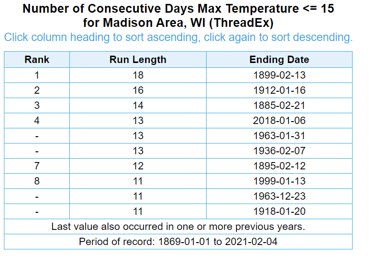
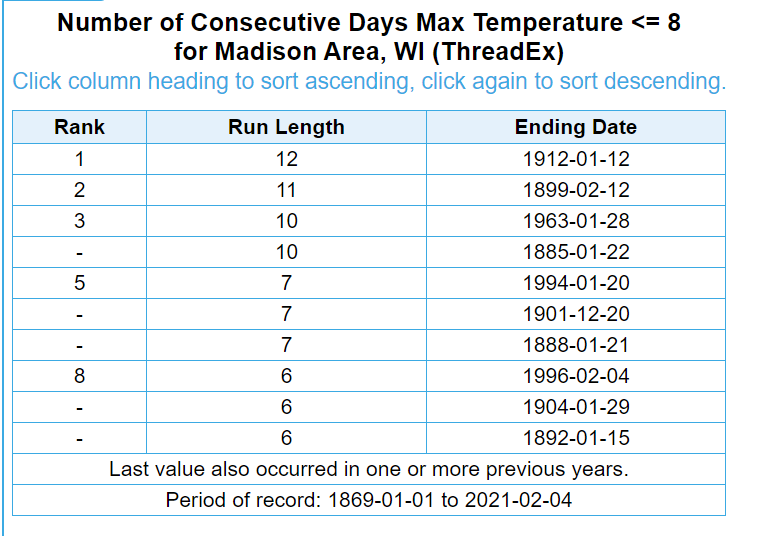
the midnight high today will be 15. But after today the highest point forecast is 8 degrees for the next week. Here's the top ten longest streaks for temps below 15 and below 8 in Madison history. Think it's definitely attainable to get on at least one of these lists by the end of this stretch