

madwx
-
Posts
2,107 -
Joined
-
Last visited
Content Type
Profiles
Blogs
Forums
American Weather
Media Demo
Store
Gallery
Posts posted by madwx
-
-
4.8" now but things are really starting to drift so this is my last attempt at a precise measurement
-
3.7” out there so far. Heavy rates but flake size is definitely impacted by the wind and lack of deep DGZ
-
subsidence got filled in quickly and it's ripping out there, winds have been picking up from the north as well
-
 1
1
-
-
hoping that band over Janesville can shift nw just enough to help us jackpot this one, will be a close call
-
1
-
-
gonna be a tightrope to get all my driveway/sidewalk clearing done before conditions become completely awful outside
-
stared in horror at the dry slot when I woke up but we only got down to flurries here and already picking back up. 2.3" with the early morning WAA. the main TROWAL feature should start impacting us shortly.
-
 1
1
-
-
unsurprisingly the CAMs are moving SE this evening
-
some of the Hi-Res CAMs keep daytime snow around here much lower and accumulations only reaching 5-7" in total. did some model sounding investigation and one main difference is much weaker omega in the CAMs. Verbatim the NAMs would give us a really good chance at thundersnow.
One negative factor is that after the initial 3 hour burst the DGZ gets really shallow due to strong WAA and it doesn't really recover until the very tail end.
-
2
-
 1
1
-
-
18z NAM drops 5.4" between 6 and 9 AM tomorrow. if we're gonna do it, lets do it full NAM style
-
3
-
-
full sunshine right now. happy to sneak this in before the next system starts spreading high clouds in
-
1
-
-
Final call of 9”. Wind is going to get very nasty tomorrow afternoon
-
2
-
-
1.8” overnight
-
Snow starting here. Will have to see if the squall makes it up here. Low will be weakening as the night goes on
-
-
1 hour ago, NEILwxbo said:
Not really a thread for this, but tonight’s clipper system looks mildly potent. It’s trended back south in the last 12-18 hours, and should deliver a good 1-2” along/north of 80 in IL, could see there being a localized 3-4” if steadier banding occurs
should jackpot this and may even jackpot Friday's storm. will get pics of the upcoming glacier
-
2
-
-
hoping for some sunshine. This is the most climatologically favored time of the year for this cold so not expecting any records
-
1
-
-
22 minutes ago, SchaumburgStormer said:
The OP run appears to be on the NW side of the cluster. Lots of member E-SE still. OP has the low over Gary.

it's crazy how underdispersive the GEFS is compared to the EPS
-
Congrats La Crosse
-
1
-
-
6.2” at the house. 5.7” at the airport. Lots of drifting this morning
-
2
-
-
8 minutes ago, hawkeye_wx said:
Tonight's sneaky little wave has been improving for my area. The 12z HRRR now has a strip of 3-4" from Cedar Rapids to Dubuque.
Going to have mountains of snow beside the driveway after this week
-
2
-
-
Hoping for some sunshine with this bitter cold stretch upcoming. Definitely makes the days more tolerable
-
7 minutes ago, A-L-E-K said:
my miss south (and lake assist) and stebo's wish cast are dead, the freak cutter is happening
but you're underestimating temps, antecedent is bad and mid levels look warm. any areas of SN/+SN will be splotchy and we'll be flipping to rain for periods of weaker forcing. I'm hoping we can hold onto a period of high end conditions or tssn with the bombing low but this looks like a palm guy storm for accums
It’s been 31 all night here despite gusty N winds and 6” of fresh snow. Antecedent airmass isn’t going to shove this one south
-
a hair under 5" now. best rates of the event are done. expecting another inch or two before midnight
-
looks like Champaign hit their lowest pressure ever. Ripping nicely with some healthy rates. around 4" now
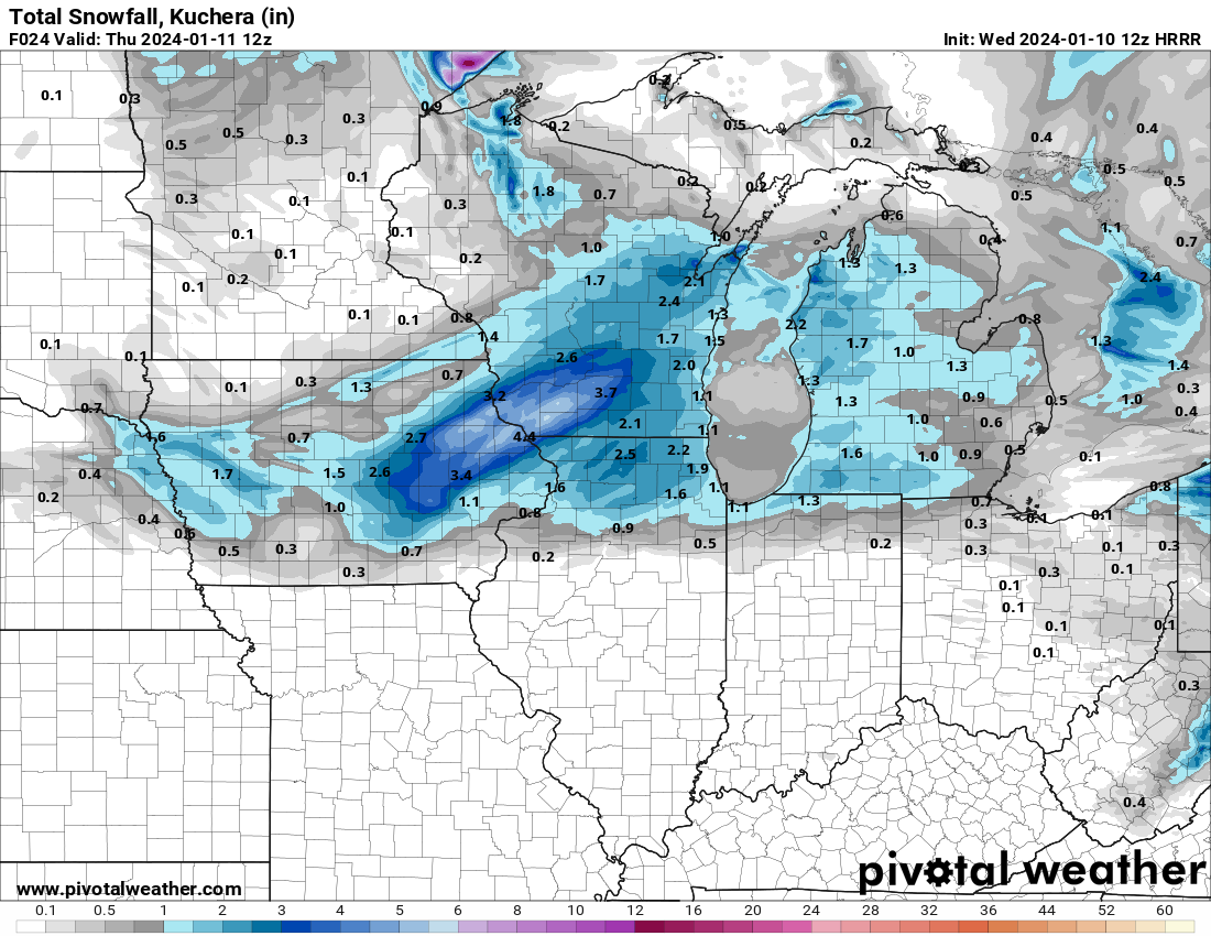
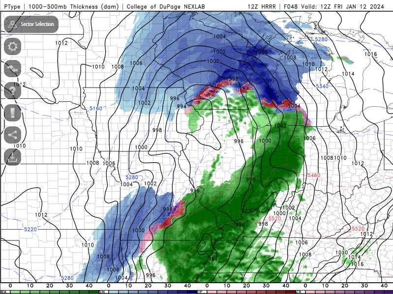
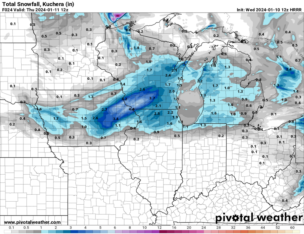
Jan 11-13th Blizzard
in Lakes/Ohio Valley
Posted
6.5" now, wind causing major drifts. during the transient subsidence bands flake size gets tiny but were still stacking