

madwx
-
Posts
2,099 -
Joined
-
Last visited
Content Type
Profiles
Blogs
Forums
American Weather
Media Demo
Store
Gallery
Posts posted by madwx
-
-
1 hour ago, hardypalmguy said:
A little cooler interlude next week but signs are there for big heat in the last half of the month.
you had a few HRs in the past month but looks like you'll go down swinging this time.
-
 3
3
-
-
Only got a few sprinkles last night. Hoping for a bit from some wrap around showers today. Otherwise drier air should be filtering in today, dews still in the upper 60s this morning
-
record of 94 today at MSN. beat the old record by 2 degrees.
-
On 8/30/2023 at 9:17 AM, weatherbo said:
Another cool one here with 42 for the low. Point has 91 Sunday!
Some other spots:
Baraga Plains 30
Kenton 31
Paulding 34
Wakefield 34
Ironwood 35
is Baraga Plains the Peter Sinks of the UP?
-
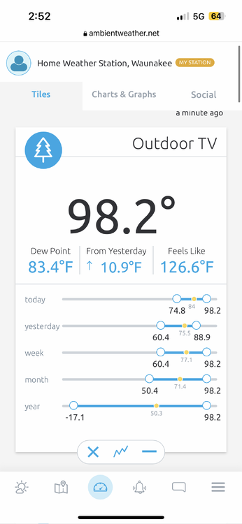
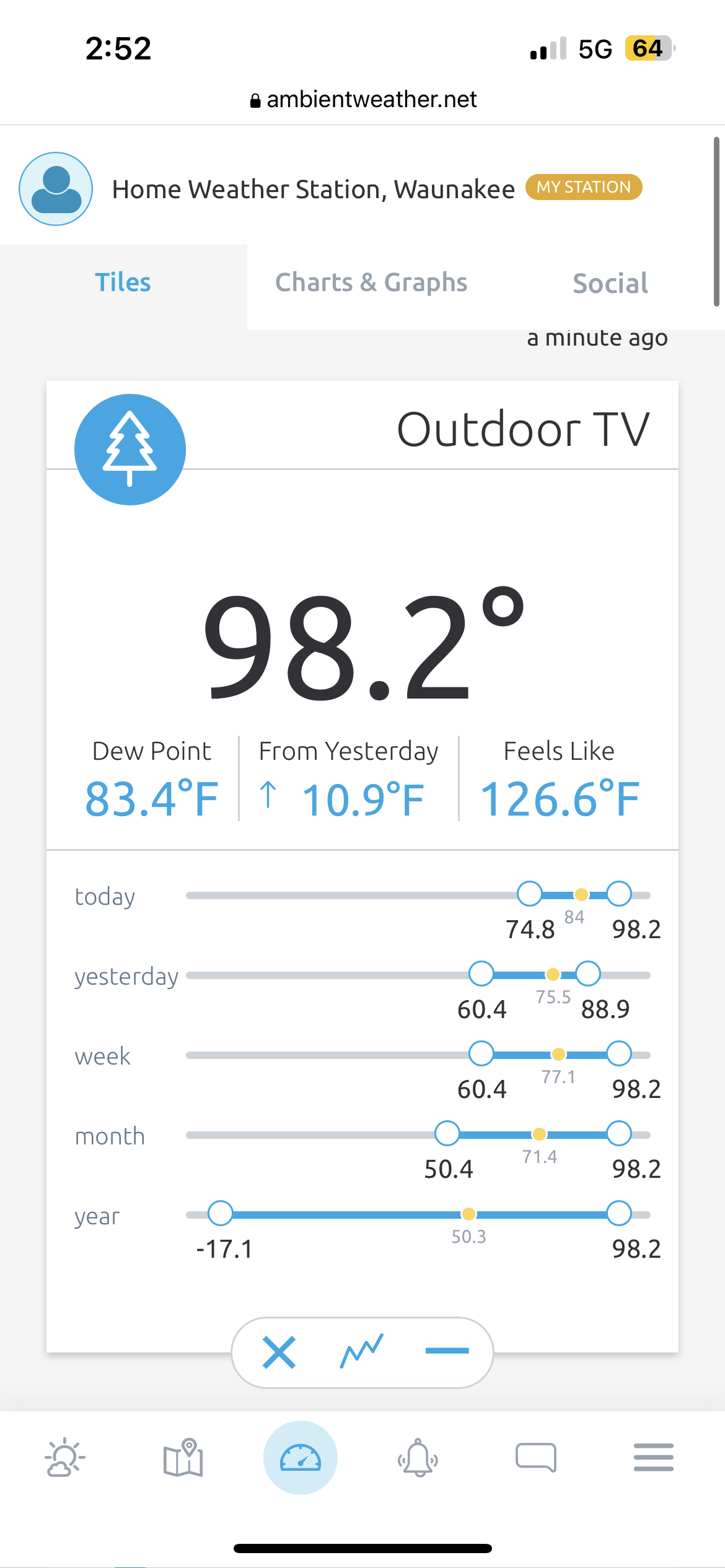
already rocking 88/80/103 here. running a bit ahead of yesterday and the frontal boundary is hanging up about 3 counties to our north
-
Heat index hanging at 105 approaching 9PM
-
Heck yeah
-
 3
3
-
-
1 hour ago, madwx said:
94/81/115 at my house right now
97/83/123
-
94/81/115 at my house right now
-
2
-
-
Only got down to 78 overnight. Today is our shot at hitting 100
IIRC the old benchmark was hitting 90 by 10 AM to be on pace for 100
-
1
-
-
19 minutes ago, CheeselandSkies said:
I'm usually not too impressed by "heatwaves," especially in recent years, but if the forecast for midweek verifies it'll be getting into some rarefied territory for this neck of the woods, for anytime really but especially this late in the summer. Been kinda rolling my eyes at all the media blather about record-shattering heat all around the world while we've been locked in this relatively mild summer pattern in the western Great Lakes, but it looks like it's finally our turn to pay the piper.
Excessive Heat Watch now hoisted for Dane County Tuesday-Thursday.For our resident southern Wisconsin climo expert @madwx, when was the last time we were under one for that long a duration?
The last Excessive Heat Watch for us was July 21-22, 2016 but that was only for 31 hours.
July 17-20, 2011 we were under an EH Watch for 81 hours that was the last one longer than this.
Those have been our only two in the past 15 years.
-
 1
1
-
-
Finished with 3.07”. All the rain was done before noon, avoiding any major flood issues
-
2
-
-
up to 2.63" with heavy rain still ongoing. flood advisory put up for Dane County
-
3
-
-
1.25” already at my house. Flood watch seems well warranted
-
1
-
-
Reeling it in
-
2
-
-
7 hours ago, hawkeye_wx said:
I hate drought, but there are two silver linings. I think I've mentioned before that drought knocks Japanese beetle numbers down to very low levels. There have been almost no beetles again this year. The other silver lining is this year's earlier drought has led to my crab apple trees being almost totally free of apple scab. I usually have trouble with bacterial leaf spot on my pepper plants, too, and I think the dryness of the foliage has helped keep the problem in check this year.
Japanese beetles are the worst, can't think of any other pest that can ruin a garden so thoroughly.
-
1
-
-
Estimating winds of about 60 mph here. Small branches and lots of leaves here. First crazy lightning show of the summer. Going to have about 1.4” inches when it’s all said and done. Can tell we’re coming out of the drought. Low spots in my backyard have standing water
-
1
-
-
3 minutes ago, CheeselandSkies said:
out of all the MD ever written, that has to be top 10 in terms of mailing it in
-
3
-
-
6 minutes ago, Chicago916 said:
Serious question. What will happen to a MCS (if and when it congeals and moves into NIL) as it barrels into the lake breeze?
it would become elevated over the surface inversion. if it was well formed it would still be able to punch through the cool layer and bring strong winds to the surface
-
1
-
-
Need some wider updrafts or some updraft merging before things really pop off
-
Initiation near Prairie Du Chien
-
1
-
-
Don’t love the billow clouds just to our NW but can see some nice ACCAS out my window
-
1
-
-
8 minutes ago, CheeselandSkies said:
Not liking the HRRR trends of splitting southern Wisconsin to the north/south this evening. As of yesterday evening we were squarely in the bulls-eye on multiple runs, of multiple models. We hit the severe threat hard at work this morning, now we might not even get any rain in Madison.
The HRRR didn't handle yesterday well at all
-
1
-
-
Already 81/70. Boundary sitting just to our north and better shear is moving in from the west
-
1
-
Category Five Hurricane Lee
in Tropical Headquarters
Posted
looks like we have the beginnings of an eye. also looks to be deviating a bit right of projected track