

madwx
-
Posts
2,117 -
Joined
-
Last visited
Content Type
Profiles
Blogs
Forums
American Weather
Media Demo
Store
Gallery
Posts posted by madwx
-
-
After a brief cold shot at the beginning of next week models are keying in on warmer than average temps flooding the region starting around the 3rd of March. Of course areas N of I80 will have to melt off a heck of a snowpack before the full warming potential can be realized
-
 1
1
-
-
2.5” storm total at MSN
-
1
-
-
One last main band to roll through here. Estimating just under 2” on the ground
-
1
-
-
Surprisingly starting as sleet here
-
1
-
-
43 minutes ago, cyclone77 said:
Have a rainer next Sat, and then another one next Tue on the op Euro, with temps above freezing each day starting tomorrow. Safe to say the snow depth will be at it's peak later today/this evening, and then all downhill from there.
I feel like this is a natural time of year to have peak snow depth so I’m not too disappointed in it gradually starting to decline
-
3
-
-
Some lightning S of Omaha this morning
-
1
-
-
There’s going to be a countywide band of overperformance where a connective band sets up. DBQ area looks prime for that
-
The start time has been getting progressively later. Looking like mid afternoon around here. First call of 2”
-
1
-
-
Made it down to -5 here this morning which may be our last day of below zero temps this season
-
The Euro still seems to be doing horribly with snowpack modelling. It currently has us with 26" of snow depth, which is 12" more than we actually have. And by the end of it's 10 day run it only decreases our snow depth by 3" to 23" even though it has a week of above freezing temps(and only 1.5" of accumulation on Sunday). Just goes to show that even the king has modelling deficiencies.

-
March looks to start off with a Neutral/Positive AO/NAO and a -PNA. This should allow the SE Ridge to flex it's muscles a bit and bring warm air to at least the SE half of the subforum. An active storm track looks to continue though there may be periods of dry weather. There is a chance of a minor disruption to the TPV around the beginning of March but any cold blast would be short lived.
Looking long range there will be a lot of snow to melt over the next month or two leading to increased flood risk. In addition the drought over the SW and plains is continuing which may allow a stronger EML to move into the region increasing severe weather chances.
-
2
-
 1
1
-
-
Actually overperformed by a few degrees today up to 25.
-
1
-
-
getting some cumulus popping up here for the first time in a while.
-
 1
1
-
-
also vaccines are very very good at preventing severe illness so at that point any vaccinated person should have no fear at getting anything more than a mild illness even if they do get infected
-
2
-
-
The forecasted cloud cover the past 2 days has been a bust here. Full sunshine now after some mid level clouds this morning
-
26 minutes ago, iluvsnow said:
Larry Cosgrove thinks a brief respite and then winter returns.....
https://www.linkedin.com/feed/update/urn:li:share:6768153727691030528/
He also predicts cold weather will last through the last week of March. Which I will press X to doubt
-
1 hour ago, UMB WX said:
forecasted high in Madison has been for around 17-19 for days. Lol at overperforming for hitting the projected high at 3pm. Spring fever hallucinations is real on the forums every Feb.
Winter is holding me hostage and I'm Stockholm Syndroming pretty hard rn.
-
1
-
 2
2
-
-
Overperforming today, already up to 17 under filtered sunshine. It seems like the full cloud cover won't be rolling in until the evening
-
1
-
-
pretty crazy temp rise this morning as the inversion broke, 20 degrees in the past 3 hours and 15 degrees in the past 2 hours.
-
1
-
-
Down to -14 so far this morning. 2 away from the record low. Got one last major radiational cooling night on Friday night
-
Radiating very well tonight. Down to -5 already
-
 1
1
-
-
We've had the 6th coldest first 15 days of February here with an average temp of 3.7 degrees. The only comparable stretch in recent history is 2007 which had an average of 4.4 degrees but ended the month at 14.4.
-
walked outside in a t shirt and full sun and 16 felt alright
-
1
-
-
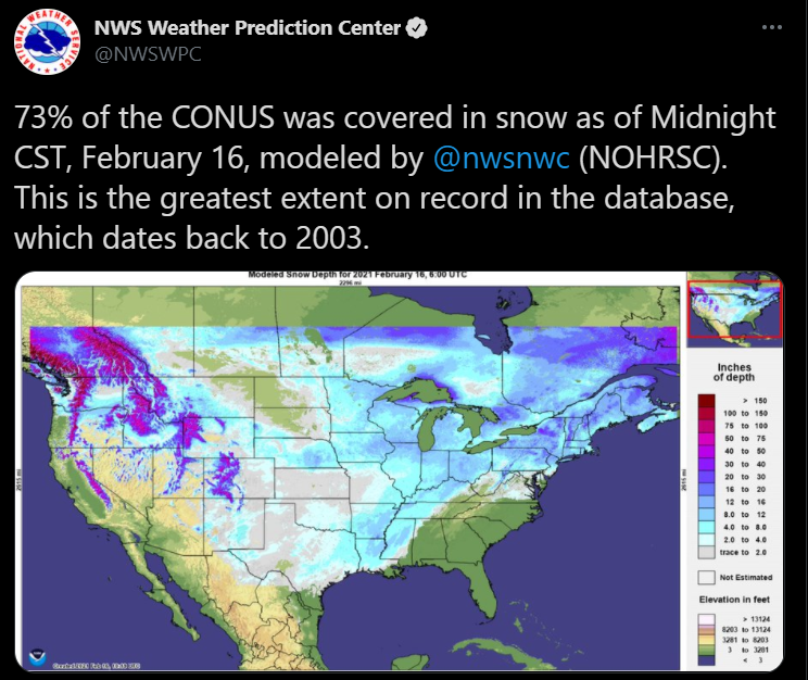
5 hours ago, madwx said:
Got slightly higher today with 73.6% snow coverage. Thinking this should be the max
This is the greatest snow cover extent since at least 2003.
-
2
-
February 2021 General Discussion
in Lakes/Ohio Valley
Posted
It's going to be real close to see if we end up colder than February 2015 here. If we do end up colder then it'll be the coldest February since 1936.
We have to average colder than 26.3 over the next 7 days to be colder than 2015.