

jojo762
-
Posts
4,228 -
Joined
-
Last visited
Content Type
Profiles
Blogs
Forums
American Weather
Media Demo
Store
Gallery
Everything posted by jojo762
-
The national blend of models is a blend of a plethora of operational models, ensembles, etc. Each of which uses their own SLR, some of the models in the blend could be using “true” SLRs, whereas some could be less complex and just use 10:1. It is hard to know what the true aggregate or average SLR from the NBM is, since there is no such a product it produces. Likewise, I tend to agree with TSA that the perceived aggregate SLR on the NBM is likely woefully underdone.
-
My guess is, sort of... Every single model utilized in the NBM uses its own SLR. I assume some models it uses might be a bit less complex, and maybe just default to 10:1, but most I assume would use "real" SLRs.
-
00z GEM is significantly less amplified and more progressive than the GFS/ECMWF/UKMET, mostly a dud of a run from a snow perspective.
-
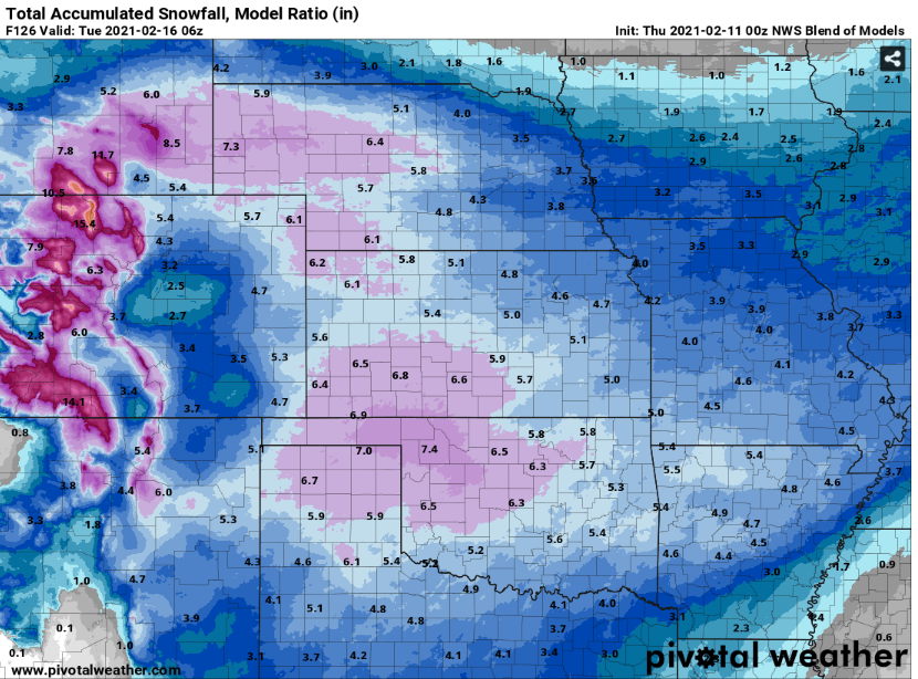
For those wanting a potentially more tempered, cautious approach, here's the NWS NBM 00z snow output for this weekend's storm.
-
00z GFS is bigly for all of Oklahoma, the entire northwest corner of Texas, all of Kansas, and the southern half of Missouri. All these areas receive a bare minimum of 6" with most receiving 10"+. That would be an impressive storm... But given that SLR's are likely to be unfathomably efficient for our neck of the woods, it's not all that unexpected with a juiced storm system. For posterity: Wichita: 11" Joplin: 12" Tulsa: 12"+ OKC metro: 12"+ Amarillo: 12"+ Dodge City: 12"+ Topeka: 6" KC metro: 4-6"
-
If the King (ECMWF/EPS) is not on board, its really not worth taking too seriously imo. That is not to say that the Euro is never wrong, but that it beats all other NWP on a consistent basis.
-
Not snow or ice-related... But holy cow the 12z GFS windchills are insane... Could have a prolonged period where we (in KC) 1. Do not get above a wind chill of zero, and 2. where we have wind chills in negative teens for 24+ hours, potentially at times below -20.
-
Interesting scenario for KC on Monday as it appears we *might* end up in the "screw zone" for this winter storm. Something that makes this forecast particularly challenging is the sharp gradient between double-digit snow potential and near-zero snow potential. Additionally, 12z guidance was split between two camps. One camp (mostly global models) has cold air shunted up a bit further north of the city, while most 12z hi-res guidance has cold air, and thus the freezing-line, much further south by 12z Monday. Most global models have KC in the mid/upper 30s range, while most hi-res guidance is colder -- more so in the 29-32 range. If hi-res guidance is sniffing something out that the globals are not seeing, we could have a fairly high-impact winter storm on our hands for most of the metro area, and almost certainly for areas north of I-70.
-
Looking like we are gonna finish near 4” of snow where I’m at in KC. Dad in Overland Park said they had about 5-6”. Not a bad storm for most of us, in one way or another.
-
Here in KC. Looks like EAX shows 4.4” of snow for my location. Honestly I’d be surprised if we didn’t end up with more. Not expecting too much ice accumulation here. Would love for the ECMWF to verify — we’d likely end up with around 8” if it did. Looks like the 18z HRRR bumped snow totals down a notch...
-
Anticipating some snow/sleet followed by a decent amount of freezing rain tomorrow morning into around noon in KC.. Some models want to hold onto freezing SFC temps into the mid afternoon, but i'm not so sure that'll come to fruition. Fairly excited about the potential for an impressive storm on Friday, but still too far out to be that excited just yet.
-
Hi-res guidance in good agreement for a fairly sizable snow event for the northern 2/3'rds of Oklahoma, and into the higher-terrain of NW Arkansas. Widespread 4-8" totals being shown verbatim on the accumulation plots, but it appears probable that warm'ish ground temps will probably hold most of those totals back a couple/few inches (especially with southward extent).
-
I love snow and winter weather, but retrospectively I actually really dislike it. All the potholes snow/ice create around here are abysmal... Omaha can keep their darn impossible snowfall forecast. Jokes aside, i'm not sure whether to be optimistic or pessimistic about the chances of a light dusting of snow on Saturday morning here in KC... Most of it would likely fall after I get up out of bed, so it'd be at least some form of entertainment for a bit. But thinking temps might *still* be to warm to definitively say we would get a snow p-type versus light rain.
-
Looks like Buffalo, Oklahoma ended up with the bullseye of 14" from the storm. It's been nearly a decade, or even more, since we last got something like that here -- I believe. After the next week or so of mild, mostly sunny weather, it appears we'll have multiple chances for large storms across the plains into mid-month and beyond.
-
NAM is quite bullish compared to every other model, but it shows over a foot of snow west of ICT from wednesday into thursday. I expect anything from a dusting to an inch here in KC (an inch might be pretty bullish though lol).
-
It’s somewhat ironic. GFS moved away from being the lone wolf showing no precip across the C plains because of its different depiction of the S/W crashing from Montana... and now the other guidance is shifting toward what the GFS had been showing. Needless to say there’s tons of uncertainty, hoping to escape with at least some snow accumulation here in KC.
-
Looks like 00z ECMWF/UKMET/GEM all trended drier...
-
It is too early to get into specifics given fairly low confidence in the forecast... But, we are certainly coming into a pattern that will be interesting to watch evolve in model land the next few days as it seems entirely possible that someone in our region could get, by today's terms, a blockbuster snowstorm. UKMET/EURO are both fairly aggressive, but with inconsistent solutions. GFS is more consistent, and dry for all of us. CMC, as usual, is a compromise between the two solutions. This isn't me just being a weenie, but I *certainly* know which models my money would be on in the D5-7 time range...
-
SE/NW pass coming soon.
-
137kt FL was measured in the southern eyewall, not too surprising given current motion.
-
137kt FL so far...
-
WPAC TCs just can’t keep pace with AO TCs (disclaimer: in 2020 only, offer not good for any other year)
-
887mb, 180mph...
-
Indeed. Hurricane Joan in 1988 made landfall in Nicaragua as a 125mph category 3.
-
That’s on the cusp of category 4 strength. If this intensity gets even close to verifying, Eta will be the strongest hurricane to have made landfall in Nicaragua. Believe hurricane Otto made landfall in Nicaragua in 2016 as a 115mph category 3 — currently the strongest landfall in Nicaragua history.


