

WEATHER53
-
Posts
6,707 -
Joined
-
Last visited
Content Type
Profiles
Blogs
Forums
American Weather
Media Demo
Store
Gallery
Posts posted by WEATHER53
-
-
1 hour ago, stormtracker said:
SO FAR, doesn't seem to be drier than 6z...but urging caution..that's just to our west...just about to get to us and I can better tell
Randall
if we get one we feel strong about then could we do Ole Ebbits happy hour before the onset?
-
2 hours ago, WinterWxLuvr said:
I’m thinking Saranac Lake, Conway NH, or somewhere between there and about Auburn ME
Does Conway still have that Inn where the Marx brothers performed some ?
-
2 hours ago, EHoffman said:
I think we were all looking for a big dog after the insane LR hype of the past month. This seems...anti-climatic. I'm still on board for this though.
All we saw from models over and over and over and over and over was monster high pressure up north staying put for weeks on end while storm after storm rolled under us.
Scrap the package and redevelop it from ground zero and give us something emphasizing an actual forecast and not a myriad of 60 panels of 0-10” that we are supposed to use as “tools” . It’s a tool all right, like Eddie Haskell
-
 2
2
-
-
Cars and snowboard and full shade areas now 0.5” with steady to occasionally moderate snow. 35F
-
Very gusty suddenly
Woke me up
-
1 hour ago, nj2va said:
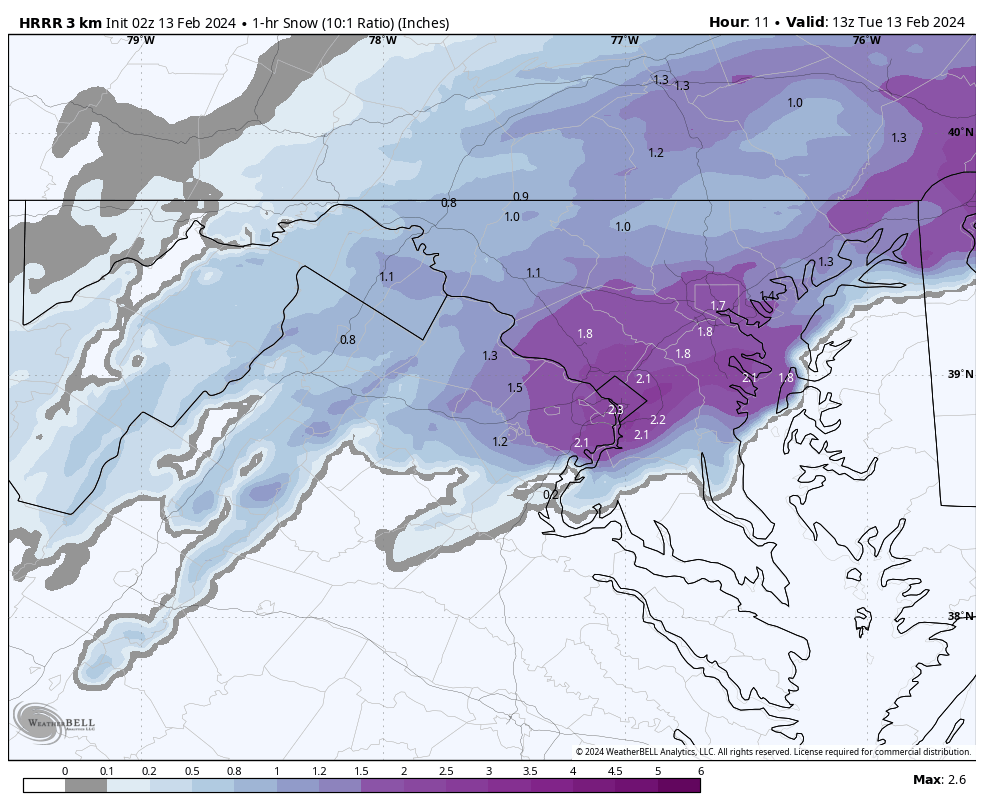
HRRR would be a really fun morning.

And might that do so longer than one hour?
-
38 minutes ago, NorthArlington101 said:

that'll snarl a commute or two
Can we call that graphic around and to right of DC border “ goin’ nutsack””??
-
Cool to just watched a 60 second mini cold surge as thermometer fell from 46.6 to 46.2,
-
 1
1
-
-
1 hour ago, snowmagnet said:
It can snow above 32. I remember a storm in late January 2000 when I watched a steady (surprise) snow storm that was supposed to be rain. My husband was taking friends to the airport in Baltimore and it was bad. It was close to 40 degrees the whole time.
Dark is a fantastic above freezing snow helper
-
8 minutes ago, MN Transplant said:
My bar is a sloppy inch and you are here talking about half a foot. I’m rooting for you.
See when one is asking for a theoretical then the word “if” is used
Calm down grump
-
 1
1
-
-
If we generally go 6”+ would this be biggest surprise since 2000?
-
20 minutes ago, NorthArlington101 said:
Thanks! Best of luck… hope you are right.And
I won’t be waffling ass all over the place the rest of the night
-
59 minutes ago, NorthArlington101 said:
sorry to kill the excitement but Pivotal's maps are bad. Still... reasonably good north of the Beltway


These pathetic ass models are still waffling all over the place. A range if 0-8” is simply jokingly unacceptable at this point with onsetv 12 hours awayv
-
12 minutes ago, WesternFringe said:
You’re watching water vapor? Wow, that’s cool, bro. They told me it was invisible in science class. Dafuq do ‘they’ know anyways?
All kidding aside, nowcasting is a thing and is also an art. What’s your forecast and for where?
ETA: ninja’d. See your forecasts above. Think you will bust high with ground truth, but good luck! Seriously
This one just evolved out of almost nowhere . I’m going to look hard at colder temp movement starting around 10pm tonight.
-
19 minutes ago, NorthArlington101 said:
I’ll ask what I always ask… what’s your forecast given what you are seeing?Thank you for asking.
Frederick and London county , becomes snow between 4-6 am with 1-1.5”ph rates for 2/3 hours and 5-7” accumulation
Montgomery and Howard flips 5-7am with 1-2 hours of 1-1.5” rates and 3-6” accumulation
DC Fairfax and PG flips 7-8am and snows heavy at times ending between 12n-1pm and receive 2-4”
Anne Arundel and southern Md stay mixed and receive 0-2”’
I predict an alarm clock setting of 5am
-
2
-
 1
1
-
1
-
-
32 minutes ago, Stormchaserchuck1 said:
The GFS/NAM were showing 1-2" for the last storm at about this time, and the RAP/Hrr had 4-6", and some places got 6-7".
Under did the two snow events and really didn’t get things right until 24-36 in advance. This event was a big fat Zero 24 hours ago and this thread had zero responses for like 4-6 hours at one point
im watching radar, wind direction shifts and satellite plus WVapor now. Models don’t matter
-
1
-
1
-
-
54 minutes ago, TSSN+ said:
These models are a mess
We need many more people on board to force changes
-
11 minutes ago, WinterWxLuvr said:
Not a chance. The NFL might though
The team won’t let him almost knock Andy over
i doubt it violated any NFL policy
-
8 minutes ago, H2O said:
KC will suspend him for first game next year
-
1
-
-
I saw this Friday night and posted early Saturday that further south and colder would be the rule. This is going to be a great tracking and obs set up and we watch for colder to mix in with wet . No need to bum out on how terrible models were until the last minute . We are going to have great obs fun albeit wee hours. I think distinction between Frederick to Gaithersburg to Silver Spring will end up irrrlevant. Wise man prevailing.
-
12 hours ago, WEATHER53 said:
Coming south?
South
and a lot of it
Models called it game over
I didn’t
Acknowledge Me(smiley face)
-
1
-
4
-
-
On 2/10/2024 at 2:58 PM, WEATHER53 said:
Mechanics with today’s heavier precipitation was south. I think that continues thru Tuesday
Coming south?
-
Further south further continuing
-
1
-
-
Mechanics with today’s heavier precipitation was south. I think that continues thru Tuesday
The Weekend Rule? Saturday 2/17 - The Icon Storm
in Mid Atlantic
Posted
Let’s get a 10pm onset so I don’t age one year in 6 hours by staying up until 4am for non starting snow!
Thanks