
FlatLander48
-
Posts
2,037 -
Joined
-
Last visited
Content Type
Profiles
Blogs
Forums
American Weather
Media Demo
Store
Gallery
Posts posted by FlatLander48
-
-
No cold air from the HP and the storm is a slider essentially and doesn't go bomb-o-genesis off the coast to produce any cold air.
-
12z GFS sends the low to Florida instead of bombing off the coast...So
-
Just now, AsheCounty48 said:
No great lakes low as it approaches either, that should help things.
Cold air push is slightly better on the 12z run at 132 compared to the 6z at 138.
-
1 minute ago, HKY1894 said:
12z gfs running, out to 108 the energy out west has a different look than last run. This is gonna be a big run for somebody just hope it’s the southeast
No great lakes low as it approaches either, that should help things.
-
 2
2
-
-
GFS says hold on to your butts for next week.Let's see what happens The whole thing seems weird with the trajectory and dual LP's forming and all, but it's there so that's the best we can hope for right now.
-
Cloudy skies in Foscoe.
-
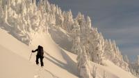
10 hours ago, Buckethead said:
Really nice (and cold) night on the Appalachian Trail. Took this with my Nikon around 10 heading up Big Stamp just across the state line into TN.
.thumb.jpg.e09ad5b18ff61cbea54b35b4ef1a7bc6.jpg)
This could be the best picture I've ever seen posted on this entire site, what a shot!
-
 1
1
-
-
We got slammed in Boone compared to most apparently. Close to 2 inches at my house at the cottages.
-
8
-
-
3 minutes ago, Tyler Penland said:53 minutes ago, AsheCounty48 said:Weather.com map already shows an icy changeover on some parts of the NC/TN line, anyone confirm this yet?
Just rain here in Elk Park for now.
You're in Elk Park? Got a friend who just moved out there 2 months ago.
-
Weather.com map already shows an icy changeover on some parts of the NC/TN line, anyone confirm this yet?
-
0z should be interesting, roll the footage!!
-

18z with a hint of blue on the northern fringe at hour 84. If we're gonna get ice, that's what we don't need tbh.
-
Can we just cancel the weekend event? Rather have nothing than what the CMC shows.
-
3
-
-
CMC is a whiff on the 14th.
-
10 minutes ago, HKY18 said:
Southern stream is so active and appears that’s not gonna change anytime soon, just a matter of timing and we will get crushed this winter. GFS has another big system moving in around 18th/19th. Would be a nice 10 year anniversary lol
Now you've got my hopes up for an 09-10 redux.
-
1
-
-
1 minute ago, Sw NC weather said:
Yes, with the secondary low forming in the gulf, it definitely has potential.
all we would've needed is for the HP to slow down 12 hours... that would have been a monster run for the mountains if it did. Nice and cold leading up to it with a solid CAD.
-
12z GFS MUCH closer to something nice.
-
3 minutes ago, BornAgain13 said:
12z GFS was almost something big , it was much colder than 6z , but still , a cold rain...
What a shocker, we need blocking to keep the high in place. Was several ticks stronger this run, but got scooted out to see, granted the trajectory of the Low wasn't great for most.
-
23 minutes ago, SnowDawg said:
Man that comma head snow in the mountains on last night's Euro was the stuff of dreams... Too bad it's 8 + days out.
Yea I mentioned that in the mountains thread, looked like an absolute beautiful changeover.
-
1
-
-
i'm discrediting the GFS currently as it doesn't even know where to send next week's storm yet, but the Euro is still close to something big, and the 0z run still has a good changeover to heavy snow as the system departs, still not out of this one yet.
-
Still got roughly 8-10 days before potential system #1 is here. The storm signal itself is there on all models, location and upper level stuff is of course different at this stage. But I'd be surprised if we made it to Christmas and didn't get a nice little storm.
-
Well 12z GFS isnt gonna be like the 6z at all. Not that it is surprising at all.
-
Although the CMC has a lot of differences, it also has the storm signal at least.
-
If it gives you any confidence, Robert is a full Gung-Ho on the pattern getting cold for someone in the east mid month.
.jpg.59bb026822f8786fe09a629e1c2258ca.jpg)
Mid to Long Term Discussion 2019
in Southeastern States
Posted
The GFS then decides to create a tropical storm and send it due south...