

lee59
-
Posts
2,584 -
Joined
-
Last visited
Content Type
Profiles
Blogs
Forums
American Weather
Media Demo
Store
Gallery
Posts posted by lee59
-
-
1 minute ago, Stormlover74 said:
No. The 1953 event didn't have 5 consecutive days over 100
ok
Just now, donsutherland1 said:No. It broke the record. The earlier extreme heat event with 5 days did not have 5 consecutive days. It had 5 days in total.
-
1 hour ago, donsutherland1 said:
Final data for Newark's extreme heat event:
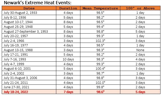
So the 5 straight days of 100 actually tied the record. The 98.6 pretty much in line with past heat waves.
-
1 hour ago, bluewave said:
We had a mix of days this heatwave with lighter and stronger winds. But NYC temperatures were in line with the South Shore sea breeze sites from JFK to ISP. So the high temperature cool bias has been pretty consistent across multiple patterns. I can still remember the old heatwaves like July 1977 when Central Park was one of the warmest sites. There are many more examples like the one below between recent years and before the mid to late 90s.
Monthly Data for July 2022 for Upton NY NWS CWA
Click column heading to sort ascending, click again to sort descending.StateNameStation TypeHighest Max TemperatureNJ NEWARK LIBERTY INTL AP WBAN 102 NJ HARRISON COOP 102 NY LAGUARDIA AIRPORT WBAN 98 NJ TETERBORO AIRPORT WBAN 98 NJ CALDWELL ESSEX COUNTY AP WBAN 98 NY WESTCHESTER CO AP WBAN 97 NY SHRUB OAK COOP 96 NY MONTGOMERY ORANGE COUNTY AP WBAN 96 NY FARMINGDALE REPUBLIC AP WBAN 96 NY JFK INTERNATIONAL AIRPORT WBAN 96 CT MERIDEN MARKHAM MUNICIPAL AP WBAN 96 NY PORT JERVIS COOP 96 CT NORWICH PUBLIC UTILITY PLANT COOP 96 CT DANBURY MUNICIPAL AP WBAN 95 NY CENTERPORT COOP 95 CT NEW HAVEN TWEED AP WBAN 95 NY ISLIP-LI MACARTHUR AP WBAN 95 NY NY CITY CENTRAL PARK WBAN 95
Monthly Data for July 1977 for Upton NY NWS CWA
Click column heading to sort ascending, click again to sort descending.StateNameStation TypeHighest Max TemperatureNY NEW YORK LAUREL HILL COOP 104 NY NY CITY CENTRAL PARK WBAN 104 NY DOBBS FERRY-ARDSLEY COOP 103 NJ NEWARK LIBERTY INTL AP WBAN 102 CT NORWALK GAS PLANT COOP 102 NY WEST POINT COOP 101 NJ ESSEX FELLS SERVICE BLDG COOP 101 NY VANDERBILT MUSEUM COOP 101 NY MARYKNOLL COOP 100 NJ PLAINFIELD COOP 100 NJ CRANFORD COOP 100 NY NEW YORK AVE V BROOKLYN COOP 100 NY NY WESTERLEIGH STAT IS COOP 100 NJ LITTLE FALLS COOP 100 CT STAMFORD 5 N COOP 100 NY SCARSDALE COOP 100 CT MIDDLETOWN 4 W COOP 100 CT NEW HAVEN COOP 100 NY SUFFERN COOP 99 NJ CANOE BROOK COOP 99 NY LAGUARDIA AIRPORT WBAN 99 NJ WANAQUE RAYMOND DAM COOP 99 CT DANBURY COOP 99 NY WESTCHESTER CO AP WBAN 99 NY SETAUKET STRONG COOP 99 CT GROTON COOP 99 NY WALDEN 1 ESE COOP 98 NY CARMEL COOP 98 CT NORWICH PUBLIC UTILITY PLANT COOP 98 NY MIDDLETOWN 2 NW COOP 97 NJ JERSEY CITY COOP 97 NY MINEOLA COOP 97 NY YORKTOWN HEIGHTS 1W COOP 97 CT NEW HAVEN TWEED AP WBAN 97 CT MOUNT CARMEL COOP 97 NY RIVERHEAD RESEARCH FARM COOP 97 NY PATCHOGUE 2 N COOP 96 NY ISLIP-LI MACARTHUR AP WBAN 96 NY PORT JERVIS COOP 95 NJ CHARLOTTEBURG RESERVOIR COOP 95 NY JFK INTERNATIONAL AIRPORT WBAN 95 There also seems to be a more wide spread list of 100 degrees readings in 1977 and the 2022 list seems to be just the eastern N.J. area around Newark.
-
.43 inch of rain here, 86 degree high.
-
1 minute ago, doncat said:
These areas have also been the driest...probobly is a reason also.
Might also mention that Newark hit 100 degrees on the nose for 3 of the 4 days before today.
-
3 minutes ago, wthrmn654 said:
Newark hit 100
2 minutes ago, Rtd208 said:Current temp 100/DP 64/RH 32%
The only major recording station in the NYC area to hit 100 appears to be Newark and they have done it 5 days in a row. Harrison N.J. near the Newark area did it twice before today. So that area in these heat waves seems to be the hottest in the NYC zone.
-
 2
2
-
-
Hit 95 earlier this afternoon here, now 93. About 3 degrees lower than yesterday.
-
20 minutes ago, bluewave said:
You aren’t going to get that kind of IMBY resolution from a satellite map. But most of Suffolk south of the LIE has had very little rain this month. The sea breeze front has been stalling along the North Shore.
Data for July 1, 2022 through July 24, 2022
Click column heading to sort ascending, click again to sort descending.NameStation TypeTotal PrecipitationBLUE POINT 0.4 E CoCoRaHS 0.15 SAYVILLE 0.2 SE CoCoRaHS 0.19 COPIAGUE 0.4 ENE CoCoRaHS 0.21 SAYVILLE 1.0 SSE CoCoRaHS 0.22 ISLIP TERRACE 1.1 NNE CoCoRaHS 0.24 AMITYVILLE 0.1 WSW CoCoRaHS 0.26 ISLIP TERRACE 0.5 W CoCoRaHS 0.26 WESTHAMPTON GABRESKI AP WBAN 0.30 PATCHOGUE 0.9 SE CoCoRaHS 0.31 FARMINGDALE REPUBLIC AP WBAN 0.32 REMSENBURG-SPEONK 0.9 NE CoCoRaHS 0.32 AMITYVILLE 0.6 NNE CoCoRaHS 0.35 BRIGHTWATERS 0.5 NNE CoCoRaHS 0.41 BAY SHORE 0.5 ESE CoCoRaHS 0.43 BRIGHTWATERS 0.7 NNW CoCoRaHS 0.46 BRIDGEHAMPTON COOP 0.53 CENTER MORICHES 0.5 N CoCoRaHS 0.53 SETAUKET-EAST SETAUKET 2.1 WNW CoCoRaHS 0.83 SHIRLEY 2.9 N CoCoRaHS 1.01 SHIRLEY BROOKHAVEN AIRPORT WBAN 1.09 ISLIP-LI MACARTHUR AP WBAN 1.17 MONTAUK AIRPORT WBAN 1.25 SHELTER ISLAND HEIGHTS 2.1 SSW CoCoRaHS 1.50 RIDGE 1.5 SE CoCoRaHS 1.66 NESCONSET 1.4 SSW CoCoRaHS 1.92 FISHERS ISLAND 0.5 NE CoCoRaHS 1.98 RIVERHEAD 1.3 SSE CoCoRaHS 1.99 RIDGE 1.8 SE CoCoRaHS 1.99 JAMESPORT 0.6 SSW CoCoRaHS 2.22 SETAUKET-EAST SETAUKET 0.3 SSE CoCoRaHS 2.27 SMITHTOWN 2.0 SSW CoCoRaHS 2.34 CENTEREACH 1.3 NE CoCoRaHS 2.48 NORTHPORT 1.6 NNE CoCoRaHS 2.49 PORT JEFFERSON STATION 0.3 SSW CoCoRaHS 2.98 MOUNT SINAI COOP 3.00 ORIENT POINT STATE PARK COOP 3.30 BAITING HOLLOW COOP 3.34 UPTON COOP - NWSFO NEW YORK COOP 3.39 CENTERPORT COOP 3.61 RIVERHEAD RESEARCH FARM COOP 3.99 Same in Nassau
-
Hottest of the year here, 98. Now down to 93.
-
93 here, my 6th straight day above 90.
-
1 minute ago, TWCCraig said:
Insane for LGA to reach a high temperature of 97 after 7PM
I think these hot summer nights may just get worse in the cities. They just keep building, so much traffic, the heat island affect increases. I remember in Florida the heat that would come off of the cinder block houses, just multiply that by who knows how much in NYC. Meanwhile still a sultry 86 degrees here after a high of 91.
-
1
-
-
Storm developed right over me but I only got .05 of an inch of rain, the dry continues.
-
That cell seemed to be forming right over my area. Some loud thunder and close lightning. Clouds were circulating but so far only .05 inch of rain as the storm moves east. I saw no signs of a tornado.
-
There seems to be some circulation in the dark clouds over me.
-
2
-
-
Loud thunder here, some appears to be to my west, maybe there is hope.
-
Once again, so far a complete miss here, as the north shore gets a few more inches after a few inches the other day. I still have less than a 1/2 inch in the past 3 weeks.
-
It has to be brutal living in the heat island areas like NYC and Newark, on nights like this.
-
1
-
-
This is the hottest time of the year and it is living up to it, currently 80 degrees after a high of 95. Good pool weather.
-
1
-
-
95.3 my high today.
-
I think this time of year becomes a little more quiet due to dry air coming off the African coast and the frontal systems that can form tropical systems retreat to the north. The real hurricane season as far as I am concerned, starts in August, and that is not far away.
-
.01 of an inch here today and that looks like all I'm getting.
-
Very muggy but missed all the rain this morning.
-
1
-
-
.44 inch of much needed rain here this afternoon.
-
Just a few drops of rain here today
July 2022
in New York City Metro
Posted
Feels good this morning with temperatures in the low 60s here.