

lee59
-
Posts
2,507 -
Joined
-
Last visited
Content Type
Profiles
Blogs
Forums
American Weather
Media Demo
Store
Gallery
Posts posted by lee59
-
-
-
I expect this wind event to be similar to the one a few weeks ago when no advisories were issued. I think this time a wind advisory will be issued.
-
Looks like a pretty good wind and rain event for this area on Sunday-Monday time frame. I know it's not snow so that turns off a lot of folks, but I like all types of interesting weather and this is at least something to monitor, especially on Long Island.
-
 2
2
-
 2
2
-
-
Very frosty tonight.
-
Flurries for the past hour here, 37 degrees. January like today.
-
Sunday and Monday time frame is still looking real interesting.
-
4
-
-
40 degrees and flurries here.
-
.74 inch of rain here today.
-
.49 inch of rain here and still raining. More than I expected.
-
2 hours ago, vegan_edible said:
unpopular opinion BUT as an upstate native, id take upstate over the nyc metro any day of the week. but if youre not in albs, cuse, rochester, of buffalo you got nothing to do but shovel
Yes plenty of shoveling, they may even have to shovel the roof.
")
-
4 minutes ago, rclab said:
Good late morning everyone. When Anthony fully enjoys winter. Per chance to dream, stay well all, as always ….
Anthony should move to Oswego NY. They had their worse snow year on record last year and still had 47 inches.
-
26 minutes ago, donsutherland1 said:
A climate link might be found, at least to some extent, if an attribution study finds that, for example, a marine heatwave altered the hemispheric pattern. AGW has led to a pronounced increase in the frequency and magnitude of marine heatwaves. Of course, internal variability will also be an important factor.
In the long-range, even as there will remain a lot of variability in season-to-season snowfall, average snowfall will very likely decline as winters continue to warm. The winters in the lower Middle Atlantic region provide some insight into what lies ahead.
Based on a regression equation that included Norfolk, Raleigh, Richmond, and Washington, DC (coefficient of determination: 0.836), it is likely that winters will become much less snowy, on average. The current seasonal average for New York City is 29.8”. With season-to-season variability, there will still be some snowy winters, but those winters will become less frequent.
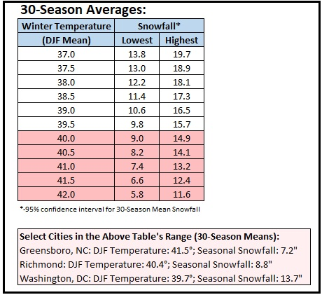
For New York City and Philadelphia, average snowfall for winters with mean temperatures of 37° or above and 40° or above were:
Winters with a Mean Temperature of 37.0° or Above:
New York City: Mean Temperature: 38.5°; Mean Snowfall: 17.5″ (n=27)
Philadelphia: Mean Temperature: 39.0°; Mean Snowfall: 12.7″ (n=33)For Winters with a Mean Temperature of 40.0° or Above:
New York City: Mean Temperature: 40.9°; Mean Snowfall: 10.3″ (n=5)
Philadelphia: Mean Temperature: 41.2°; Mean Snowfall: 9.9″ (n=9)Those numbers are broadly consistent with the results from the regression equation.
Below is the distribution of seasonal snowfall for winters that had mean temperatures of 37.0° or above:
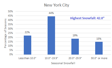
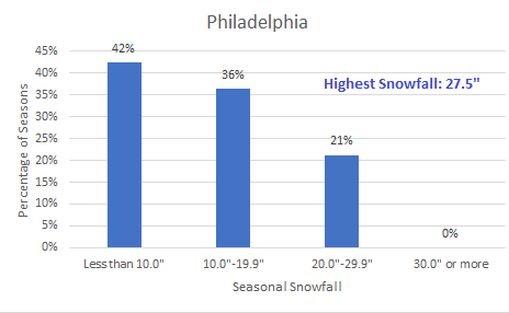
If this data is representative, New York City's 30-year average snowfall (Central Park) could decline to about 20" by the mid-2030s. There will still be some big years. Winter 2009-10 in Baltimore and Washington, DC, provides an example of such an outcome in a warmer climate.
You make a good point but I wonder if the increase in precipitation could help mute the downfall in snow. The last 30 year period saw snowfall totals actually go up in NYC, not because of lower temperatures (temperatures actually went up) but the increase in precipitation. Eventually, of course, this will have less of an affect if temperatures keep rising.
-
1
-
-
Few flurries here.
-
2 minutes ago, Dark Star said:
It it's not reported, it never happened, therefore the forecast was accurate. Just joking. Normally, winds too often underperforming. This was one of the events where they did over perform. I think the models generally looks around 850, and forget things like friction to keep them from reaching all the way to the surface?
The most interesting one to me was the report from Jones Beach. For probably a couple of hours they reported sustained winds of tropical storm force.
-
45 minutes ago, forkyfork said:
models had below freezing temps for the entire metro last night. oops
How about the other night with 40-60mph winds in parts of the area and it was not forecast and I didn't even see any wind reports by the NWS.
-
23 minutes ago, donsutherland1 said:
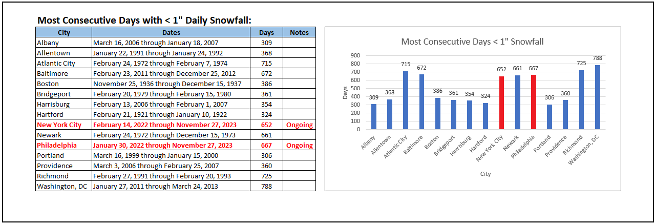
Through November 27, both New York City and Philadelphia are continuing their longest streaks on record during which less than 1" daily snowfall was measured.
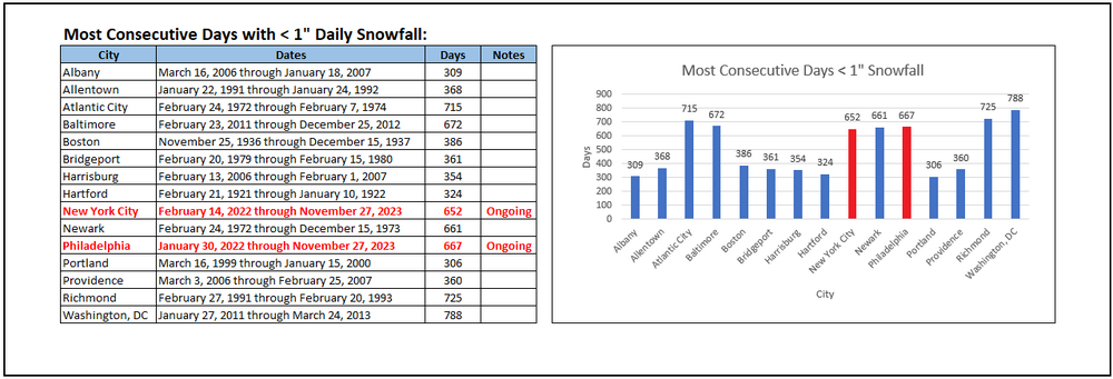
This record should have an asterisk. Much of NYC did have over an inch if I remember correctly. I think the only station not having over an inch in the NYC area was Central Parks .9 of an inch.
-
2
-
-
I did not see from the NWS wind or rain reports from last nights storm.
-
 1
1
-
-
Last night was the most interesting weather event in a while, at least in my area. Have not had a 40mph wind gust in a while, not much rain however. Only .18
-
1
-
-
Just hit 40mph here.
-
The strongest winds, at this point, seem to be in the western half of Long Island and SW Ct.
-
16 minutes ago, jm1220 said:
We're probably going to be on the more windy east side of the low but less rain. Big west trend with the low/rain today.
Yea, the low probably tracked further west than predicted.
-
Jones Beach gusting to 53mph. These winds were not forecast.
-
2
-
-
I think the coastal is intensifying earlier and stronger than expected. Wind now gusting over 30mph. the high here is 34mph. Finally some rain, not much up to now, only .02 of an inch.
-
1
-
-
12 minutes ago, weathermedic said:
Got this a little while ago from Notify NYC:
Notification issued 11-26-2023 at 18:59.
Due to extremely high winds, the NYC Ferry Rockaway Route is suspended for the remainder of the evening. Consider alternate routes and allow for additional travel time.For more information, please visit https://www.ferry.nyc/service-alerts/.
Wind gusting to 29 mph at JFK as of a few minutes ago. 32 mph at Breezy Point.
I was just going to post the wind has really picked up here, gusting to 27mph.
A decent storm will develop through the northeast USA Sunday Dec 10, 2023, rapidly deepening Monday morning in its departure. Worst expected 5P Sunday-5A Monday.
in New York City Metro
Posted
The heavier rain seems to be a little earlier than what I expected. On and off heavier showers.