

Carvers Gap
-
Posts
14,237 -
Joined
-
Last visited
Content Type
Profiles
Blogs
Forums
American Weather
Media Demo
Store
Gallery
Posts posted by Carvers Gap
-
-
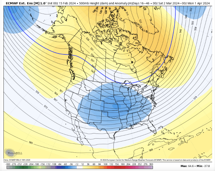
Maybe the first 9-10 days of March are warm, but sitting in the middle of week three on modeling (early week 2 of March) is a cold snap. Have to remember that February is a shortened month. 23 days on a Weeklies run can be fairly accurate - just speaking of longwave patterns. That fits w/ the MJO rotation above. This is one of these years where I just think winter is not quite done. I could easily be wrong. For those new to the area, March can be good. It just hasn't been lately. To me, it kind of equates to early December - it can be good but more often than not it isn't. The Weeklies have not been super reliable of late, but the progression makes sense. It is almost like the Feb pattern has been delayed a bit. And the 30 day map below is with the first 9 days warm....
Now, the NAO has been woefully hard to predict this winter, and it normally is. It often won't give a lot of lead time when it sets up. Can we get the elusive double block, and have it hook over the top? Maybe, but this winter this look has only verified 1 out of 3 times it has been shown at this range(which isn't terrible for week 3-4 modeling). But that is a winter pattern below.
I don't think I need to say this but will. I am fully aware that we are fighting climatology with each, passing day. However, you just never know. Kind of have to watch cold snaps between March 7-15th which to me is the furthest we can really say climatology will allow a snowstorm in the valleys. At some point, we will have a snowy, spring pattern.
-
 7
7
-
 1
1
-
-
1 hour ago, Matthew70 said:
Warm with sharp cold fronts usually lead to severe wx. I can do wo that type of wx.
I think about the time we all think it is spring and are happy with the temps....gonna be some wicked cold temps. I can see a signal during week 4 which shows that, but during shoulder season, those cold shots can be a mirage. SSW cold dumps West and then heads eastward.
-
2
-
-
Masters of the Air has been really good. There was a 75% casualty rate for the 100th. 50% of our WW2 airmen never made it home. I cannot imagine getting into a plane, dealing w/ -40 to -60F temps, being shot at, maybe bailing out of a plane pulling crazy Gs, and then if you were lucky, limping home in a badly beat-up Fortress and changing gears mentally to exist in a place that had no idea what type of tempest you had been in just 4-5 hours earlier. Courage doesn't begin to describe what they did.
I saw a guy pumping gas w/ a ww2 veteran license place last weekend. Just doing the math, he was probably 95+ years old. He looked every bit of it, but he pumped his own gas in his truck, hopped into the driver's seat, and sped off down the road...I couldn't keep up.
-
4
-
-
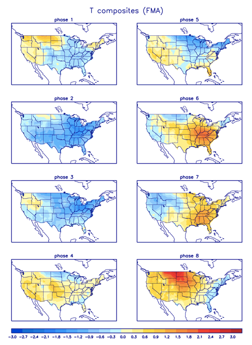
As we begin to make the slow, steady climb towards spring, it is very important to understand that the MJO phases for "what is cold"....they change when we hit March. We want to stay out of 6-7-8. Very sharp cold shot showing-up right around the 25th. So two cold fronts, 17/18th and the 25th. I follow cold fronts during spring, because if there is going to be mischief...that is when it shows up.
-
4
-
1
-
-
We get the 12z GFS southeast jog, and then we get this....
There will be no weather posts next July from me. The weather sure looks nice in Pasadena. Not too bad today here either with the exception of the wind.
-
2
-
 5
5
-
-
41 minutes ago, Daniel Boone said:
18z followed South trend.
You are just gonna have to look out your back window and see it up the road if that verfies!
-
2
-
-
3 hours ago, tnweathernut said:
Systems all year have been trending south and east. Let's see what happens when we need it most. lol
When we need it most...it is gonna head to Akron! LOL.
-
2
-
-
The 12z Euro has now found the 24-25th cold front. It also has the rain/snow line over TRI for Friday night into Saturday. Would not be surprised to see WWAs posted with that. The GFS has the same trend, but was mainly over SW VA. Operationals have definitely trended colder yet again. No idea if that holds. This is VERY similar to what happened in early January.
-
2
-
-
The 12z GFS has much more eastern trough yet again this run through 330. A ridge rolls through, but interesting. The GFS would likely pick up on this first.
-
3
-
-
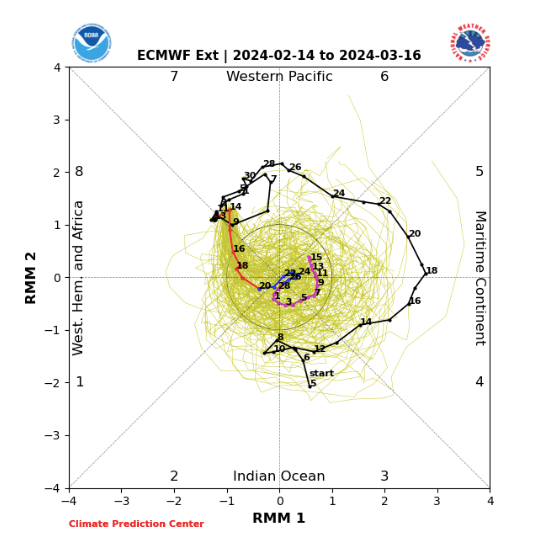
The MJO appears to be "potentially" getting ready to take the tour of the cold phases. If it does, this is a monumental bust of the CPC MJO plots which were trying to go back into the warm phases without going into cold phases. This has occurred all winter - CPC plots trying to skip either the cold or warm phases. I am not sure if the CPC plots are just representative of modeling bias...IDK. I think that is why we are seeing operational modeling find cold fronts that were not present 3-4 days ago.
-
3
-
-
Additionally, the 6z GFS has light snow over TRI Saturday morning (less than an inch of snow). My guess is higher elevations such as the Plateau and Apps see some light accumulations, and MRX has a short discussion about that this morning in their disco.
-
3
-
-
This morning, the 6z GFS and 0z CMC are picking up a fairly strong cold front around the 24-25th. Looks like a ridge rolls through just prior to that. Let's see if that holds. Decent look.
-
2
-
-
22 minutes ago, kvskelton said:
Looking at the origin point of that return I immediately thought of the Bays Mt Reservoir that sits on top of the mountain. Lake effect virga?
 I, too, thought it was strange occurring on that side of the mountain.
@Carvers Gap I knew that would be in your neighborhood! If the black SUVs show up, get downtown and I'll hide you at my office! It was nice to meet you face to face a couple years ago. It is indeed a small world!
LOL. You know it!
You know, that does look like that could be the Bays reservoir. I drove over that section of I-26 about 3:45. I don't remember anything unusual. On the other hand, I was trying not to hit the potholes on the bridge or get hit. For those of you who don't know, I-26 from Kingsport to Johnson City is like the autobahn in German. Better be on your toes...rubbin is racing on that section.
-
2
-
1
-
-
For the KY/VA/ TN border....Saturday can't be ruled out if a last minute SE trend takes place.
-
2
-
-
I am liking the 25th as a window to watch.
-
2
-
-
1 hour ago, Holston_River_Rambler said:
If you watch radar scope it stopped almost precisely at sunset.
I wonder if there was some low level moisture hitting the mountain at a right angle. Seems odd to see it on the upwind side of the river. I was off the forum this afternoon, and hate I missed it....literally was right over the house. Does that feature count as an elk?
-
2
-
-
4 hours ago, Holston_River_Rambler said:
Ok, @Carvers Gap @kvskelton @Icy Hot and any other Kingsport adjacent folks, what is going on here:
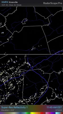
Almost all those pixels make this look like it is coming off of Bays Mt, but a couple of frames show some hints that it might be coming from somewhere near Carter's Valley. We've seen this band during NW flow after storms sometimes, but today is unique.
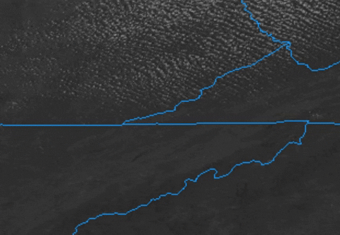
Here is a zoomed in view with counties added:
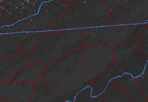
GOES 16 is so clear, I can see the point of Bays Mt there and Kingsport's urban sections around it.
At the little swag in western Sullivan county there is a swag, for lack of a better term, in Bays Mt almost exactly where that radar echo is streaming:

That is a tiny feature, but Im wondering what is going on up there to cause that radar echo under what is almost a totally clear sky to my eyes.
You always find interesting stuff. I think I can see that view out my back window every day.
-
2
-
-
8 minutes ago, Met1985 said:
Oh yeah I understand and I know exactly what you are saying. The paper mill I worked at was kind of like that. Right on the river, waste water plant, lots of boilers and furnaces, we practically made our own weather in the winter.
We definitely make our own weather. But there are a lot of micro climates as well. Holston's Sullivan abode is probably about 100 yards from my parents. (We have never met that I know of...small world though) I am a bit up the hill. On Friday's they test their stuff. Things shake. LOL. That looks like an industrial release. My original thought was aircraft chaff, but we really don't have a lot of that activity here. Plus, that looks like it is coming from a singular, stationary point. Make me think waste treatment which is about where that plume is. Ya'll, if I am missing for a few days, you know the black helicopters have shown up.
@1234 probably lives about 6-7 miles as a crow flies. Honestly, there are several Kingsport posters - I won't name all of them. I met @kvskelton(by chance)once when he was surveying in my neighborhood!
-
4
-
-
Just now, Met1985 said:
That would explain a lot lol!
I updated that post...you can read the rest of it. LOL. It may just be confluence. It does tend to happen there, but normally it is on the other side of the mountain. Options would be open pit, new gas furnace, hydro demotion, or their waste water treatment plant. But it is right on top of it if I am reading that map correctly. Again, they make stuff that keeps us all safe and gets dropped from planes during shock and awe.
-
3
-
-
2 minutes ago, Met1985 said:
This is definitely fascinating especially in our area. I've seen us here in the mountains have moderate snow with absolutely nothing showing on radar because the moisture is so close to the ground. Kind of like a fog precipitation cloud. Very interesting for sure.
Under that spot is one of our nation's national defense plants. We make a lot of "stuff" here in KPT - chemicals, paper, and things which cannot be named or people show up at your house. Sometimes it can get a little sideways. LOL
-
3
-
-
That is where that weird little confluence sets up though.
-
1
-
-
Bravo Alpha Epsilon? Was the hydro demolition going or maybe it was some sort of release? Were they burning in the pit?
-
1
-
-
6 hours ago, Daniel Boone said:
FTW !
It rarely fails us....thunder in the mountains. Just a wild rule that is probably more accurate than most weather models. Congratulations to everyone seeing snow. Pics or it didn't happen! LOL.
-
2
-
-
Somebody is gonna have to post some snow photos so those of us getting the liquid variety can live vicariously.
-
3
-
2
-
February 2024 mid/ long range
in Tennessee Valley
Posted
I want no part of severe wx. Very destructive to people's lives. I know many follow it, and I find no fault with that.