

Carvers Gap
-
Posts
14,245 -
Joined
-
Last visited
Content Type
Profiles
Blogs
Forums
American Weather
Media Demo
Store
Gallery
Posts posted by Carvers Gap
-
-
1 hour ago, Holston_River_Rambler said:
I'm probably gonna
A) be wrong
and
B ) get a comment about slinging spaghetti on a wall
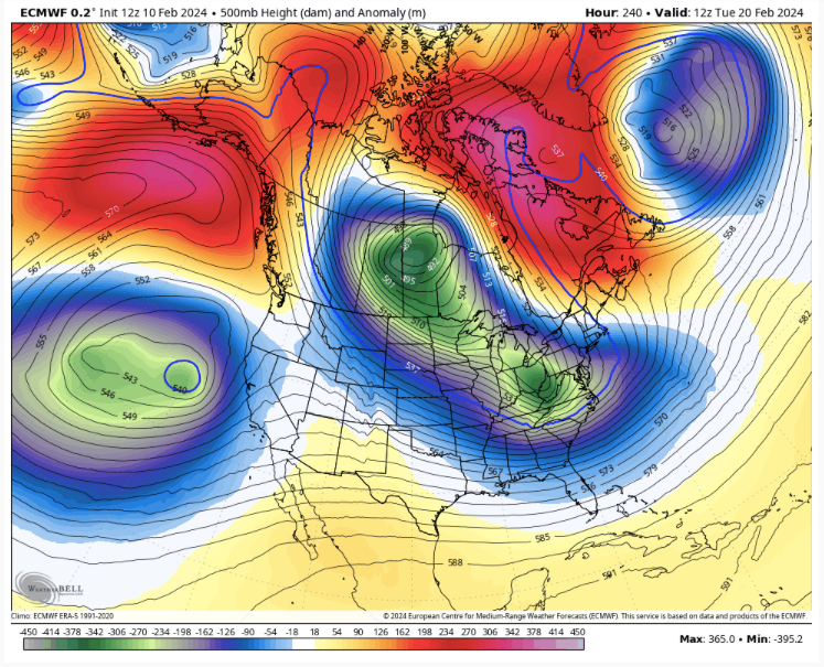
but I think we are about 7 - 10 days away from seeing a meaningful end to this cluster of a pattern we've been in. I was really hoping about this time last week we'd see some better signs by yesterday or today and yeah the Euro above is nice, but I'd like to see all ops at least showing a way out.
Doesn't have to be an epic look. Doesn't mean it has to show snow. All I'm asking is for two weeks without a trough slamming into California. Hopefully the Euro is the first hint of changes brewing.
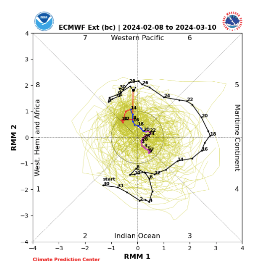
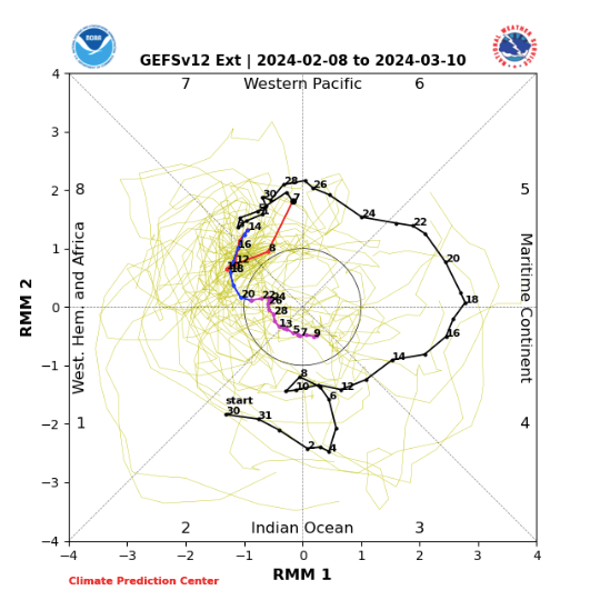
That satellite imagery Jeff posted yesterday is not too encouraging, but if we can believe the GEFS RMM today (updated late) the mean splits the difference of 30 members between several big phase 8-1-2, several CODs, and several, I guess, status quos:

I especially like the one member that goes back to phase six and stays there for a week.
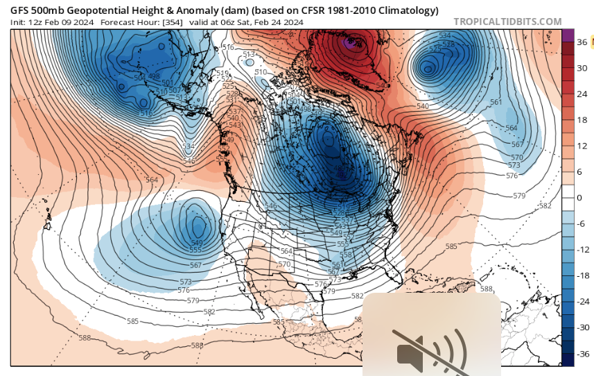
GFS OP likes the COD. I still think it lo amp/ borderline traverses COD 8-1-2-3. If it plays out like it did in January, our best chance for a January redo may be around the Raindancewx date of March 1.
I think the NAO is the gonna be the driver. We did this dance during January. Once the NAO got its act together, things started shaking. Plus, we are in the zone where the SSW (not the current one, but it could be I guess), but the one before could be showing up on mid range modeling and long range.
edit: all we need is the MJO(like you have there) to just be not so much a pain in the neck, but just let the potential NAO drive the pattern and force confluence.
-
 2
2
-
 1
1
-
-
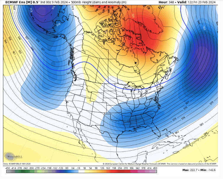
The 12z Euro control went freaking bonkers w/ the cold. I doesn't even look like the 0z run. The ensembles does provide some support for that. Man, this reminds me of the mid-Jan cold snap. The models didn't have it...until they did. Time will tell.
-
2
-
-
LOL. I knew that would happen. Send me a Christmas card.
The EURO (aka Dr No) pours cold water on early spring talk....man. It traps a piece of the TPV, and there she goes. That is a classic SSW response. That is a -EPO/-NAO couplet.
-
4
-
2
-
-
And ha, ha...right on schedule the 12z Euro brings in a massive cold front around the 20th. Not a "stop the presses" look, but a "similar to early January look."
-
1
-
-
But I will say, extreme cold IMBY is often followed by winter breaking quickly for spring. 84-85 did that.
-
1
-
-
Just now, Holston_River_Rambler said:
I think we've been fighting that since I've been typing on this site, lol.
Truth. We just need the Pac to be neutral as I think we are in a -NAO cycle. LOTS of discussion as to why the water is so warm east of Australia. That has caused absolute chaos this winter in regards to the SOI and MJO. I can't find a great explanation for it, but that area has a lot to say about our weather. What we need is a true weak la Nina or a true weak el Nino. Those weaker phases work...moderate, strong, or nada don't work.
-
1 hour ago, midwoodian said:
Reading between the lines on recent posts…fair to say it’s 50/50 we get another cold shot or prolonged cold snap in the Tennessee Valley?
.Between Feb 15-20th, yes...almost a certainty. As to whether it is prolonged? I think that is reaching the "highly unlikely" range of options. I tend to think of prolonged being 7-14 days. I don't see that at the moment, but you never know. Nothing is a certainty in the weather, except what is occurring right now. I would say 70/30 that we don't see a prolonged cold snap, but we could see mini-cold snaps. Looks like a pretty typical spring pattern setting up for March with swings to warm and cold. But again, modeling is all over the place right now....the mid-January cold shot was not seen until about 5-7 days out. It is looking likely that the LR predictions to a return to cold are likely going to bust pretty badly....but not for certain at this point.
-
At this point, I am still not totally sure modeling is sensing the -NAO. The LR right now has me super skittish. That is a common error, so I feel there is still a chance that modeling could turn colder if it can fight the Pacific. So, I do hold out a little hope that could happen. Also, if that storm deepens around the 18th...we could also see the NA pattern shift the cold eastward.
I should note that I don't think the Pacific is going to be much help during coming winters due to the IO/MJO set-up. I think we are going to have to rely on Atlantic blocking which is what did the trick during mid-January. As soon as the NAO left, the cold pattern broke down within hours.
Is the SSW at fault? We have seen that occur before, and our pattern went into the crapper within a few runs of it showing up......Asia looks cold as it should. Asia is the primary spot SSW cold goes(then western NA, and then eastern NA last as priorities).
-
3 minutes ago, Holston_River_Rambler said:
Looks like it also snows/ wintery mixes in CAD regions of NC for something like 36+ hours
That solution certainly makes more sense than a rainer on the 12z GFS. The western NC mountains should get popped w/ that set-up. E TN remains a dark horse with that set-up.
-
1
-
-
With the exception of something unexpected(LR modeling missing a cold front or a bowling ball perfectly placed), I believe winter at lower elevations is probably over after the Feb 18 system(unless CPC MJO plots are erroneously skipping cold phases which they certainly could be in error doing). Now, anything can happen during March. But as for temps, I think winter is done after say the 25th...and honestly it was over when the cold left during mid-late January. February should finish with much AN temps and rain. We are going to need every drop of this come next fall as I suspect drought takes hold late next summer along w/ temps that should be in the furnace through early October. Enjoy the cool temps and rain.
-
At this point, to be clear, the phase occurs too far to the East...but that is an impressive look. Sometimes, things have to be admired even if they don't affect us on a certain run.
-
2
-
-
That is the type of storm which can change up the entire NA wx pattern if it deepens an eastern trough. It has been there for several days, but that is a pretty big run for the NE.
-
1
-
-
Too warm on that run, but that is a FORMIDABLE solution on the 12z GFS around Feb 18th. That is likely a blizzard for portions of New England and inland mid-Atlantic. SLP rapidly deepens. If we can get that cold front to speed up, that is a big storm.....
-
1
-
-
The 12z EPS has a monster NAO which suppresses the storm track after Feb 24th. At minimum, the mountains should get hammered.
-
4
-
-
And if that get trapped under that block, it may well just not move.
-
3
-
-
That is pretty impressive, and this is how Atlantic blocking "could" help. The run to run departures right now are impressive to say the least. This is the 500 pattern from 12z. The NAO basically forces the PNA to pop by driving a piece of the TPV directly into the Lakes. That puts the boundary for winter storms over the TN and Ohio Valleys. Anyone remember what this looks like? Hint: don't look back too far. And yes, the sound is muted....!!!
-
4
-
1
-
-
The 12z GFS at 342 is a great illustration of one possibility of what happens just after the NAO tries to hook into the SER. Impressive stuff.
-
2
-
-
This is the run-to-run temperature change for the GFS...and this is just roughly 9 days out. To me, this implies very cold air is about to enter the pattern when models swing like this. That is about as wild as it gets from run-to-run.
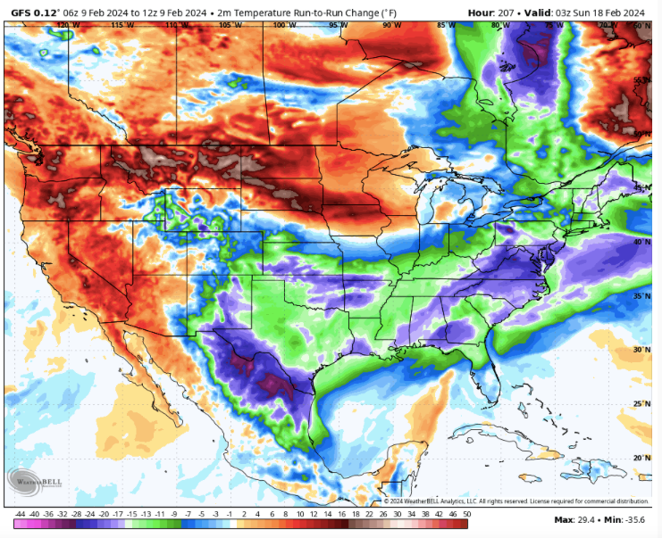
-
4
-
-
10 minutes ago, Holston_River_Rambler said:
12z GFS at hour 190ish looks beautiful. I’ll take that look even if it ends suppressed later in this run.
Been a pretty consistent look during that time frame. A strong cold front driving this far south during February is likely going to get a reaction.
Cosgrove has a great post today about all of that.
-
4
-
-
This is why we have to be careful to write-off winter - me included. If the 12z CMC is even remotely correct, the Euro MJO plots are in error. Now, I think it warms up right after this, and then gets cold again after that. It is that subsequent warm-up that modeling whiffed on. A detail like that will get washed out at range on an extended map. The 12z GFS has us in the 20s for the timeframe shown below. The CMC does have a cold bias, but it will often nail a cold shot at this range. It got the mid-January cold shot.
-
4
-
-
Actually, LR ext modeling has been exceptional this winter. 4-6 week modeling is going to miss at times. We still don't know yet if it has missed for the 14th to the 7th. Sure looks like it is set to miss for at least part of that time frame, and that happens in this hobby. What we do know is that it really doesn't get cold during phases 4-6 very often during winter, and we have just been reminded of that. Modeling has also been struggling mightily w/ the MJO. Here are this morning's updated extended plots. One is warm and one is cold. Now, those are derived from yesterday's runs. If the Euro is correct, winter is over. If the GMON is correct, winter is still breathing. Now, the GFS suite was really the first to see the trek into the warm phases. The Euro has tended to go COD this winter(over and over again), and has been in error each time.
The CFS MJO from today looks decent...beware of solutions which go into the COD as that has been an error all winter. To me, this makes more sense.
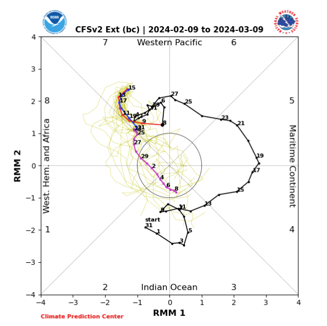
I am about 50/50 that winter is over with the exception of a well-placed, bowling ball. There are a wide range of MJO solutions right now, but they tend to lean towards either a fast trek through the cold phases or not at all.
If forced to make a choice, what do I think? I tend to think cold is still on the table. Why? The -NAO. Modeling will be very, very slow to trend towards the consequences of that block at our latitude. As evidence, modeling was very late in recognizing the details of the mid Jan cold outbreak which was NAO driven if I remember correctly. I tend to think we see the NAO try to hook into the SER, and that is what is driving modeling nuts! It is what is after that which I am interested in. After that, could be a very significant cold shot. This is almost exactly a repeat of the pattern in January - even the comments in our forum are nearly identical to that lead-up. When/if the NAO matures, it could well send the mother load, and modeling will be late in seeing that. So, it is very wise to temper expectations, but I would hesitate in completely throwing out winter completely. Winter may well be over, but a late Feb/early March NAO is formidable(and VERY difficult to predict) and I highly doubt that is worked out yet. This is probably, as Holston points out, a situation where delayed is more likely than denied. I think the map below is a strong possibility. Crap Pacific, but the Atlantic tries to works some magic just after the NAO hooks into the SER.
Beware of the big red ball over Davis Straits.............if real, it is going to have a say.
And a very decent look on the 12z GFS mid-month to boot.
-
1
-
-
I should add the NAO will likely drive the pattern for the 2-3 weeks beginning around Feb 14...complete with hooking into the SER for a short time after the 20th. But right before the NAO exits is when I expect it to be the most cold. That is prob late Feb or early March. Be thankful for the NAO, if it wasn’t there....it would be 70+ each day.
The biggest issue is that our source regions are very warm thanks to the MJO driven sauna. Remember that modeling erroneously had the cold continuing through the warm phases. It is possibly making the same mistake now by perpetuating warmth during cold phases.
-
3
-
-
I had a longer post, but here is the bottom line. The pattern flip is still there. The cold to fill the eastern trough is largely absent on the GFS easily in the pattern change.
This change is eerily similar to late December. 500 flipped but temps took some time to adjust downward. It wasn’t until mid Jan that the pattern matured. Also, modeling at the time completely missed that last cold shot embedded in the pattern, and then missed the warmup. I think that MJO makes a full transit for the colder phases of those plots. I doubt modeling has accounted for that yet. I do think a warmup is embedded now in that pattern change, and that reflects the confusion in modeling that we have seen for a few days.
Once the MJO transits 8–1-2-3, winter is over for the valleys most likely. I think the West is in for a very cold end to their winter in late March as the SSW is set to clock them.
-
4
-
-
Again, something is probably in error...either the CPC MJO plots or recent trends in modeling. My money is on colder solutions. It could be we have a ridge rolling through the northern Plains w/ cold right behind it in the d10-15....can't tell at the moment.
-
1
-
February 2024 mid/ long range
in Tennessee Valley
Posted
The PDO has been a pain. We discussed that in depth last fall as a potential thorn. It certainly(more times than not) puts the default trough in the West.
That said, the Mountain West has been STRUGGLING w/ precip deficits. Could be a very rough summer there. Fortunately, I think Jackson, WY, got some snow this week. So, it is not helping them a ton. There are snow machine businesses that haven't been able to run their machines in the dead of winter. Cooke City, MT, had bare ground two weeks ago, and their main street was pavement. I have never seen that during winter. If the PDO was fully on board, there would likely not be bare ground there. But.......it is incredibly common to have severe cold in the eastern Valley, and then that be it for winter. Same was true for me as a kid. I did wonder when it got so cold, if that might be it.
But I tell ya where it has been cold - Alaska. I follow Stan Zuray (Yukon Men) on Facebook. He is a great follow on social media. He is a fisheries expert. He has been posting about how cold the interior has been there.
I think the main culprit this winter was the December GOA low on steroids that created that monster chinook. It scoured Canada of snow, and made it tough to rebuild the cold there. To me that has been a problem. If that had not occurred, we would have been cold from the last week of December through the third week of January. We managed to get some of that snow/cold deficit back, and even get back into positive territory in terms of snow...but I think that chinook put us in the hole from a source region standpoint.
But let's see....January changed-up unexpectedly. It certainly looks like a warm signal, but the atmosphere doesn't have to do what modeling says. The storm/no-storm on the 18th could change things up much like the Plains storms did in early Jan.