

Carvers Gap
-
Posts
14,252 -
Joined
-
Last visited
Content Type
Profiles
Blogs
Forums
American Weather
Media Demo
Store
Gallery
Posts posted by Carvers Gap
-
-
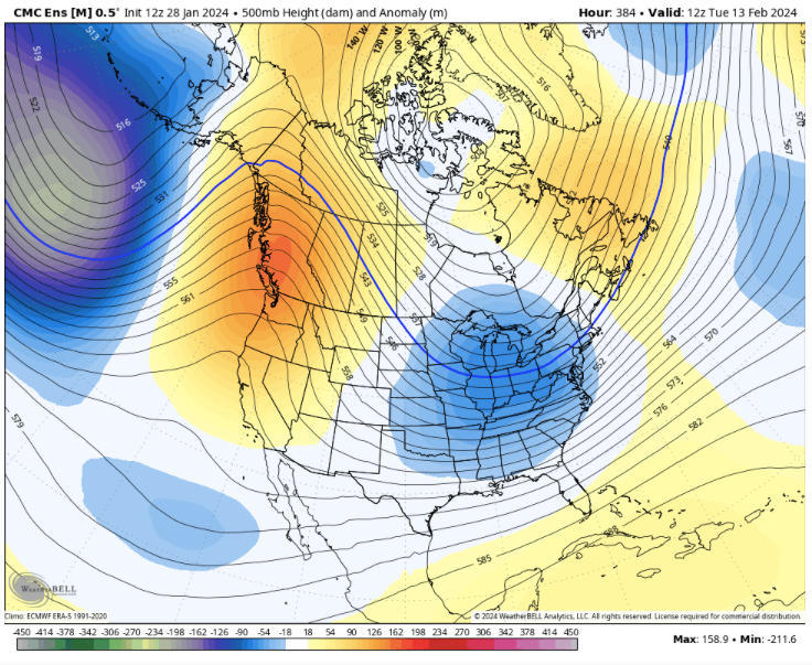
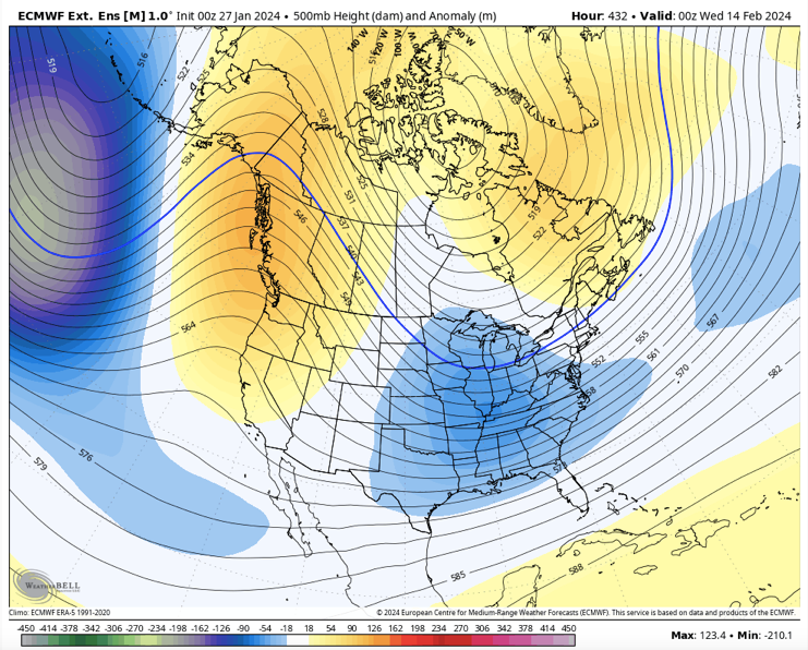
Cosgrove must be smiling.....high amplitude phase 8 is on the table. We have crossed the rubicon and are in phase 7. Most MJO plots are quicker today. I would expect some pretty cold solutions will start showing up just after Feb15. That idea is also supported by LR ext modeling.
-
 5
5
-
-
14 hours ago, Itryatgolf70 said:
Anybody have the euro weeklies from today? Didn't see it posted.
Yeah, they come out every day now - new thing.
They looked maybe a half a day faster at 500 w/ the trough sliding into the eastern half of the country on the 13th. I don't think it will immediately flip cold(very much like when the pattern set-up in early January). Temps "should" begin to slide BN(or at least seasonal) by the 15th. I still wouldn't be surprised w/ some can-kicking, and I also wouldn't be surprised if it got here earlier. The MJO is very slowly coming out of phase 6. On some plots, I think it was out of 6 yesterday....CPC, it was still there. Plots for CPC should update any time.
Honestly, if you look at the GEPS ensemble from overnight, it looks basically like that.
-
3
-
-
And I should add that long pauses in winter are customary in the valleys. We don't do wall-to-wall winters very often as that is an extreme anomaly which doesn't occur but maybe every 15-20 years at best. Having February look that decent is a massive bonus and that is a textbook Nino look.
-
3
-
-
The 12z GEPS now looks like the EPS ext from yesterday....The GEPS gets there about 24 hours quicker. Either way, this is what we mean when we begin to see Weeklies and global ensembles in sync. Pretty good agreement between two different models.
-
2
-
 1
1
-
-
I feel like the 12z GEFS does not support the operational run. I would say half probably have a decent snowstorm somewhere in the SE....there are some progressive OTS members for sure. However, the GEFS has more amped solutions than even the GEPS. Not in a place where I can post...
-
1
-
-
1 minute ago, Silas Lang said:
Yeah, now that you mention it, I seem to remember this happening a few years ago. I was thinking "there is no way that low travels due north"...and it very well did! lol
Wasn't there another one last year (maybe the year before) where the low travelled straight into the mountains?
Regardless, I don't like energy transfers. Hope it stays a simple Gulf low for all of us.
Sneaky big storm at this range right now. Boone was on this from day one.
-
1
-
1
-
-
I would say roughly 40% of ensembles from both the GEFS and GEPS have a big winter storm for the SE and/or MA. That is a pretty stout signal at this range. I think for the TN Valley, this is a tougher sell at this point. I would be fired up in the MA. E TN and NE TN(especially) are in the game...Gefs seemed to have more TN storms.
-
2
-
-
12z Gefs and Geps....
MSLP and individual surface low placement maps (where all lows are on one map), show a trend towards a deeper low with more members to the north and west of the mean placement. Plenty of time for this to get bigger. Classic Nino, low road track. The Canadian ensemble has some big dog tracks.
-
3
-
-
3 minutes ago, Silas Lang said:
And the CMC is...something. takes the Gulf low due north to Nashville then transfers to Asheville then finally goes to the coast with another low popping off the coast of GA at the end. Sort of crazy look all over the place.
Textbook Miller B, Mid Atlantic track. Energy goes through middle TN and then hands off to the Piedmont. Not good for us, but certainly that is a big storm signal for them and maybe NC.
-
3
-
-
Silas, you posted it. Awesome. That is a powerhouse. The GFS is often too progressive (exception was last winter), so that could be big.
-
4
-
-
The 12z CMC has a strong Miller B solution for the MA and another lower latitude system after that. I wasn’t sold on that timeframe earlier...but the potential is there for sure. The 12z gfs went OTS, but if I showed its solution with a powerful slp over Louisiana...might make one think twice.
-
2
-
-
3 minutes ago, jaxjagman said:
Actually the more i look at this map i'm gonna still say mid month still
I think you are right. Just eyeballing modeling today, there is a slight delay there, maybe 24-36 hours. I think models have been too quick to break down the ridge. Modeling has been off-and-on though for several days re: cold. It may well be that serious cold is about to return to NA, and it's causing models to go haywire in the LR.
-
I had the unfortunate honor of taking one-too-many computer programming classes while in college. I had a math class where we had to write calculus programming in basic - gag. I could do fundamental programming, but calculus rarely agreed with me. Fortunately, I had a buddy who was great at calculus, and we handled the programming together. Computer wx models are nothing just programming code. Take some time to think about that. I will say this, some of what we see on modeling looks like infinite loops - meaning the program gets locked onto a trend and cannot move to anything new. We see that in the form of feedback on the NAM at range. We have seen that with recent MJO plots. When it is warm, modeling tends to stay warm. The opposite is also true. Sometimes the change itself is feedback. It seems that problem has been worse this winter. I also think that three years of Nina data has really skewed modeling towards Nina responses. In reality, this is a textbook Nino winter so far. If I hadn't looked at a model and had been blindfolded from all internet data, this feels like a Nino winter - cold, damp, rainy, cloudy, some cold, big snows, grass gets green early(no lie...weird characteristic of Nino winters).
-
3
-
-
7 minutes ago, Itryatgolf70 said:
There has been snow and ice in end of Feb early March many times, but at that point, we have unfortunately wasted a whole month if no progress is made with mjo moving forward. That why I'm doubting eric webb and others opinions of a similar progress with mjo that closely resembles 2010. Unless things change in a hurry lol
I just roll with the ensembles at this range.
-
1
-
-
Just now, Itryatgolf70 said:
I wonder which model really has the best idea of the mjo progression or has had the best idea? Larry Cosgrove said yesterday for a return to winter, we want the mjo to progressively move from the warm phases to cold phases with a strong enough coherent structure. I definitely hope it will do that
I don't think any of them have been particularly good this winter. They have not handled the Nino rotations well. It is almost like they are pre-programmed to Nina tendencies, and have missed badly due to that.
-
1
-
-
8 minutes ago, Itryatgolf70 said:
I'm hoping we don't continue to kick the can down the road, which would lead to the weeklies getting pushed back more and more. I definitely want one more opportunity at a return to winter here.
The 12z GFS wasn't a can kick(from timeline which has been discussed here) that I could tell. Cosgrove had thought that the cold would return well before the 12th. Earlier operational runs supported that return to cold earlier in the timeline....the 12z operational booted that. I think he has adjusted his thinking and is saying President's Day though early March. I will say, I didn't like see the EPS stall that trough out West. The control kept it moving. This is feels like late December deja vu. The conversations are very similar. What we do know is the firing of convection over the MC was strong, and at some point it should be reflected on the CPC MJO plots. I have been super adamant that this warm spell was going to be legit. I would not be surprised at some can kicking as these eastern ridges are TOUGH to eliminate. They are super stable. I am just riding with the ensembles right now.
-
JB has a great post on the past ten days of MJO trends. It is truly astounding at how bad the plot has been. I didn't realize it had been that bad. I kind of suspected it, but yikes. I would screenshot a portion of his post, but I think those are his thoughts...and are his to share publicly or not. I don't Twitter often, so maybe he posted those three plots.
-
I will say this...if the Euro Weeklies had been derived from 12z, I don't think they would have looked nearly as good. It could be a hiccup, but 12z was the first time that global ensembles seem to break from their Weeklies. What does that mean? It means it would have been very tough to see global ensembles move to a trough in the East after d16. This disconnect also happened right after Christmas. Even the Weeklies blinked and then returned to their old, colder forecasts. It took a few days for ensembles to adjust to MJO forecasts. Day10-16...it seems global forecast models struggle w/ cold, and wash it completely out. But there may be reasons for that this time.
Again, as for the MJO...it is a mess. Choose your own adventure. What we do know is that right now it has raced across phase 6 which it was not forecast to do. That said, it "should" stall (during the next few days) given satellite and OLR looks. Where it stalls is going to be important. The MJO definitely slowed on this morning's run. Getting most of the way across 6 is a big victory. Let's see if it hits the wall. If it continues to race across 7, we will know the MJO plots were in major error. Big test coming up.
Even Cosgrove this evening seems to have been knocked of his spot a bit by the warm, warm run of the 12z GFS suite. Let's hope it was a blip.
-
1
-
-
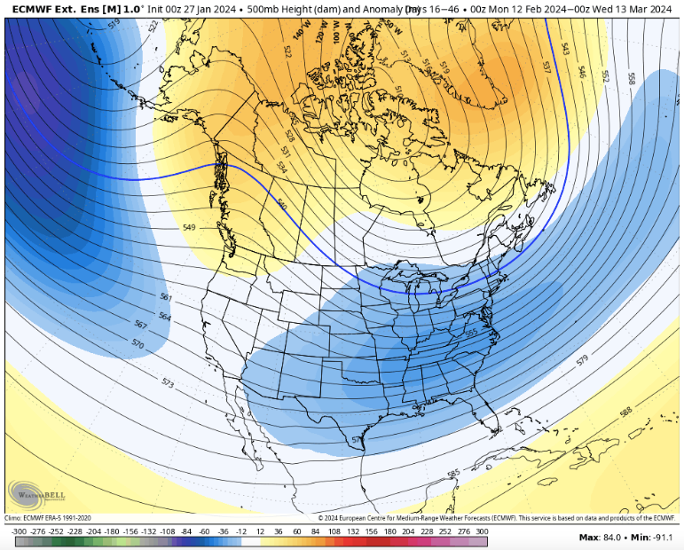
And this his how you draw up a 30 day map...the groundhog better get some sunglasses for Feb 2 if this is right.
-
6
-
-
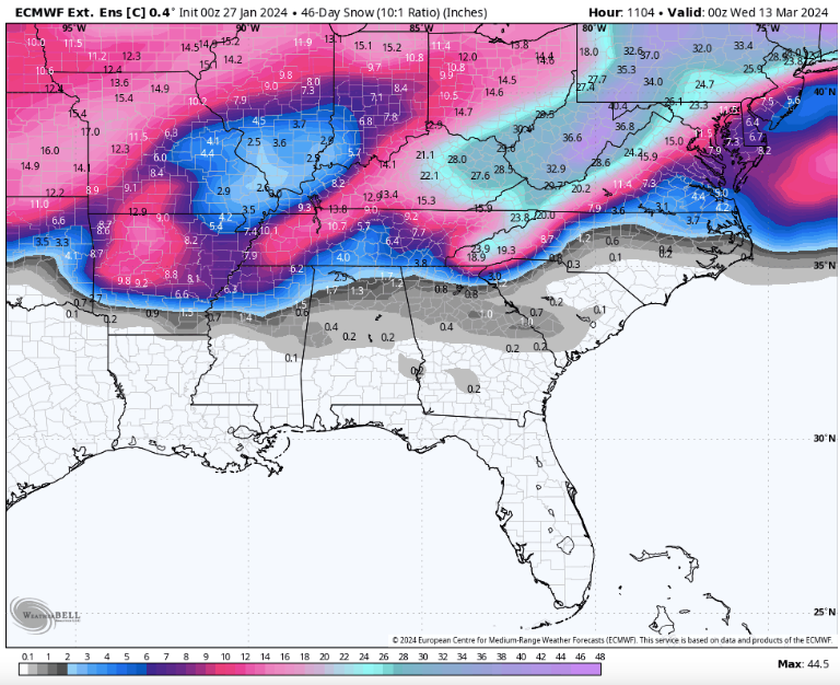
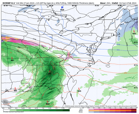
The Euro Weeklies control again today w/ big numbers. Couple of light events during the last weeks of Feb. Most of this falls during two storms in early March. The ensemble was similar to yesterday w/ snow into Tallahassee this run.
-
3
-
-
Winter Storm Warnings up for the Apps....
URGENT - WINTER WEATHER MESSAGE
National Weather Service Morristown TN
255 PM EST Sat Jan 27 2024

TNZ018-041-043-045-047-072-074-280900-
/O.NEW.KMRX.WS.W.0002.240128T1200Z-240129T1800Z/
Johnson-Cocke Smoky Mountains-Southeast Greene-Unicoi-
Southeast Carter-Blount Smoky Mountains-Sevier Smoky Mountains-
Including the cities of Doeville, Mountain City, Neva,
Shady Valley, Trade, Laurel Bloomery, Hartford, Cedar Creek,
Erwin, Unicoi, Limestone Cove, Hampton, Cades Cove, Elkmont,
and Gatlinburg
255 PM EST Sat Jan 27 2024

...WINTER STORM WARNING IN EFFECT FROM 7 AM SUNDAY TO 1 PM EST
MONDAY...

* WHAT...Heavy snow expected above 3000 feet. Total snow
  accumulations of 3 to 6 inches, with higher amounts possible on
  the mountain peaks. Winds gusting as high as 40 mph.

* WHERE...Mountains of East Tennessee above 3000 feet.

* WHEN...From 7 AM Sunday to 1 PM EST Monday.

* IMPACTS...Plan on slippery road conditions. Gusty winds and snow
  will reduce visibility to less than a quarter mile at times.

PRECAUTIONARY/PREPAREDNESS ACTIONS...

If you must travel, keep an extra flashlight, food, and water in
your vehicle in case of an emergency.

The latest road conditions for the state you are calling from can
be obtained by calling 5 1 1.
-
1
-
-
Interestingly, the GEFS and GEPS ensembles have the low trekking across the GOM...it just doesn't turn. Timeframe definitely has my attention. Great posts by everyone.
-
4
-
-
@Holston_River_Ramblerthat could evolve into something good though. Could easily be a slider if blended with the GFS. Definitely worth watching. Still a ways out there. Good find.
-
3
-
-
19 minutes ago, Holston_River_Rambler said:
I bet some folks in TRI SWVA and Eastern KY would have liked the overnight Euro too:
Looks like a hybrid Miller w some energy transfer verbatim through middle TN. Very good MA look and maybe even North Carolina.
-
1
-
 1
1
-
February 2024 mid/ long range
in Tennessee Valley
Posted
Just reading across other subforums, I see a lot of disappointment that winter has taken a hiatus for the first half of February. LR ext modeling has been barely budged in suggesting the cold comes back around the 14th - give or take 48 hours. Ensembles have been locked-in for weeks. The MJO has certainly led the way on this. The great thing is that modeling has been very accurate with this warm-up. That makes me think they are probably correct about having roughly a 3 week stretch of cold to close out winter. I hear the "we are giving away half of February" talk. For the past three years, we have pretty much lost all of Feb due to Nina climatology and the trough being stuck in the West. The next good thing is that global ensembles have the transition to cold. Sure, there could be some can kicking, but....the cold being depicted to return the 14-15th time frame is not can kicking. Extended LR modeling has barely budged with that timeframe. It is possible it may have shown the 10th at some point, but the 500 pattern has been consistent for some time. It is actually remarkable work by LR ext modeling if it pans out. I suspect the coldest pattern will be Feb20-29th....maybe we can score a leap year storm. I get that climatology starts to fight us, with the exception of one area....big late winter and/or early spring snow storms.