

Carvers Gap
-
Posts
15,670 -
Joined
-
Last visited
Content Type
Profiles
Blogs
Forums
American Weather
Media Demo
Store
Gallery
Posts posted by Carvers Gap
-
-
1 hour ago, nrgjeff said:
Y'all are starting to sound like me! Welcome to the Dark Side.
AI versions pretty much followed their ops versions. Whatever. I'm going with the Canadian. Sounds good, eh?
I want "Chattanooga snow Jeff" back!
-
 1
1
-
-
3 minutes ago, PowellVolz said:
Parts of North Central NC saw their first accumulating snow fall in 3 years on this past Friday. I understand parts of SC going snow free for a while but it’s crazy to think that it’s been 3 years since areas on the NC/Virginia border has seen snow. I just always assumed that area wasn’t prone to snow droughts.
Super similar to NE TN. We aren't in a snow drought here, but many areas are in a "big storm" drought. NE TN normally cashes into a big storm from time to time. I think it is La Nina weather patterns - drought city there and here.
-
 1
1
-
-
5 minutes ago, PowellVolz said:
Since this is the most used thread as of now I’m going to drop this Pivitol Weather update in here and let a mod place it in the appropriate thread. I’m putting here to give everyone an opportunity to see it for now.
https://x.com/pivotalweather/status/1879926384421994786?s=46&t=LVg8BRWCh1zZb6F_t95EVg
So, I have finally learned how to post Tweets on this forum. It won't work with the prefix "x". Just take the address and put it on Word or Notepad. Take the "x" out and replace it with "twitter." Then, you get this...
-
 2
2
-
-
I mean if you simply say, "Which one makes the most sense given the incoming cold?" It is an easy choice. Two model runs make no sense given climatology. Charleston snow once in a blue moon? Sure. North Florida snowstorms? Man, I won't be able to resist marching myself into the climate forum(please don't start discussing that here!!!!). E TN could sneak into this. That said, these systems next week definitely have a lot of aspects of a Carolina snowstorm. I remember seeing the thousands of posts when we were in the SE forum about their storms. This fits about all of the criteria need for snow for them.
But....every once in a while the E TN posters would reel one in w/ a northwest jog. It was pretty glorious. Those folks haven't had snow in a while, so I will go easy. But I am still hoping maybe we can reel one in across the Apps.
I think a big storm is possible. IF, we are looking at the Weds-Fri fram right now...remember modeling loses systems often between d5-8.
-
4
-
-
The 12z GFS ensemble is a more southerly CMC track. The 12z GFS has gotta be tossed. I'll toss it. The Euro just as ridiculous. The Canadian looks much more realistic.
-
 1
1
-
-
I don't think the Euro or GFS is right at 12z. Remember the Key West snow showers? It didn't even verify to anything close to that. i do think the best chances are between Tuesday and Friday. Friday is still 8 days away. This ain't even close to being worked out.
-
2
-
-
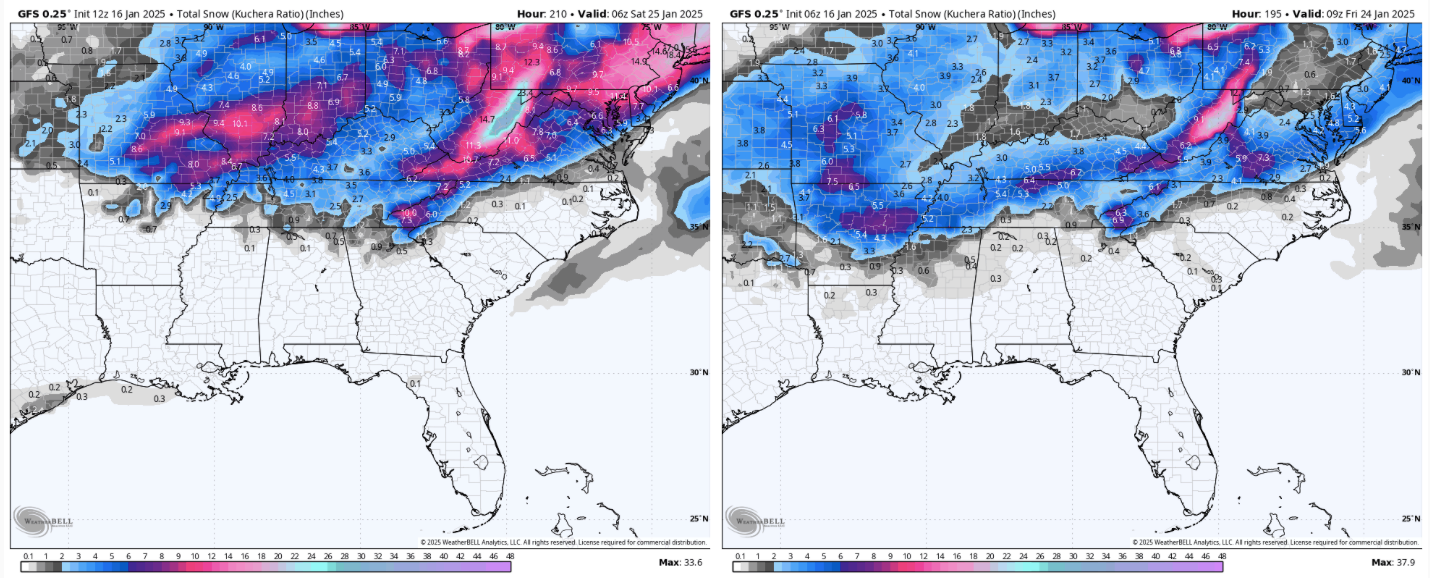
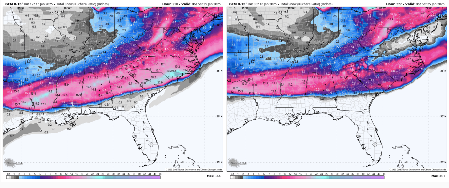
Let's just take a minute and admire how different these maps are. The first is the GFS. The second is the Canadian. Left thumbnail is 12z and the right is 0z for the CMC. 12z and 6z, respectively, for the GFS. The CMC is composed of two systems. I can't even remember what the GFS was going. Both have a first system thump, and then we diverge. Might be just a little bit of feedback on the CMC. The CMC does have a bias towards feedback over South Carolina.
Take a minute and notice the differences over the NE from run to run and between models.
-
5
-
1
-
-
1 minute ago, *Flash* said:
I’d love that. Not sure how the RGEM is performing this year. Regardless, my expectation for the midstate west of the plateau is set to post-frontal flurries late Saturday night with depleted moisture by the time the colder air arrives.
That first system is such a wonky set-up. My expectations are super low. But models are spitting out some decent numbers. It is trending into a bigger storm in the NE which I think is having massive upstream impacts for the next system. How that first system gets handled is making for some wild variations for mid-week. 12z suite is the pro wrestling at this point - anything goes. Models are throwing chairs, jumping off the top rope, and tagging out.
-
4
-
1
-
-
The GFS can score coups, but if the Euro is still suppressed....I am gonna have to toss the GFS. It was waaaaay to far north with last weekend's system, and didn't correct until late. If the CMC jogs 150 miles northwest, E TN gets thumped. I have no idea what the trend is at this point. HOWEVER, the ensembles (prior to 12z...haven't looked at those yet) are pretty much the CMC/ICON tracks.
-
3
-
-
3 minutes ago, Wurbus said:
The difference between the GFS & CMC at 120 hrs is staggering at the 500mb level.
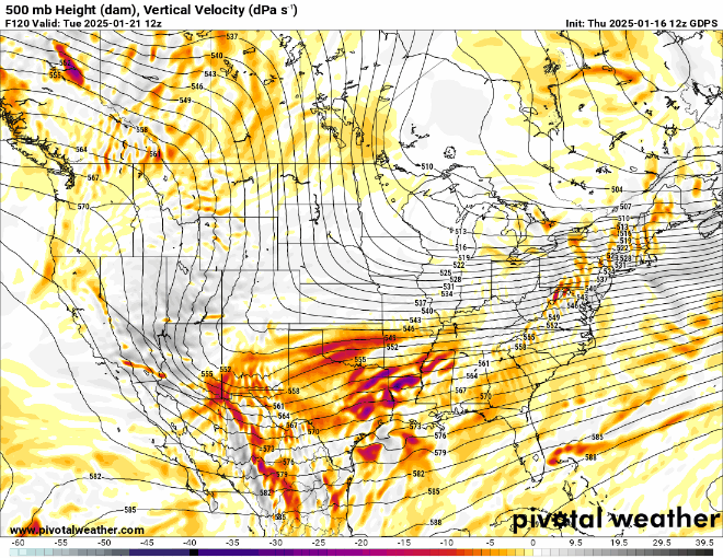
The difference at the surface is central Georgia or Chicago. I think the GFS is having some NAM problems.
-
1
-
-
The 12z RGEM implies that middle TN could get thumped on Sunday with 3-4". I know this is a bit late to be discussing it(and we are watching mid-week), but the RGEM was not benign nor is the GFS.
-
1
-
-
@tnweathernut and NE TN/SW VA peeps. I know tnweathernut has mentioned this Sunday as sneaky. The GFS has some decent totals for Sunday as that system on the 12z GFS is stronger off the NE coast after it leaves here. That implies that this "might" be a late bloomer on modeling. Are we looking at mountain amounts which are smoothed into valleys or is this a legit 3-5" opportunity at the last minute? For folks not in the mountains, often modeling will make it look like TRI is going to get thumped when in reality it is mountain totals bleeding into other grids due to smoothing. In reality(from a bird's eye view from directly above), often the rain snow line can be quite abrupt in reality.
-
1
-
2
-
-
34 minutes ago, Reb said:
ICON skirts ETN

IMHO, right where E TN folks want it at this range. Nice trend.
-
3
-
-
This is how much the GFS is on an island. The 0z Euro AIFS doesn't even have the system above Mobile, Alabama. There are really two impulses. There is one on the 21st-ish and next on the 24th-ish. Modeling is probably struggling with which one to amp. But on the AIFS, neither are there. Again, looking at ensembles, we are going to need to see those ensembles begin to move today or this one is gonna be tough to reel in.
Overall in the long range, it looks like we take a TBD big-time warm-up after next week. The GEFS ext MJO ends winter for all but the northern most latitudes of the forum and higher elevations. The Euro Weeklies race across warm phases and then stall before hitting phase 8 of the MJO. We want the Euro to be right. Otherwise, things are going to be blooming by the end of February. When we start talking about the MJO, usually that means we are about to see extended warmth. I suspect that seasonal analogs(almost all are warm for Feb) are correct in February being much AN with March cooling back off. Chance for a little late season magic if analogs are correct for March.
So far, the 2018 analog has been money. I had it as one of two analogs for my winter forecast. 2017 was the other.
The one fly(a good one) in the ointment for February could be the PDO flipping. If it flips, it will try to trump the MJO and has the ability to do so.
-
2
-
-
8 minutes ago, matt9697 said:
All of Middle TN looked good on the last two runs of the GFS
Ensembles barely graze areas north of 40. There is almost zero support for frozen precip north of 40 right now on ensembles. It is possible that operationals are leading the way. I certainly can see that is possible. But the the ensemble mean is waaaaaay down there. I would really caution using the GFS right now. It was woefully wrong with the last system, and is on a total island with this next one. I hope it is right. That means I get to see winter one last time before a possible much AN February.
-
2
-
 1
1
-
-
For NE TN peeps we are going to have to root for this to move northwest a bunch. Ensembles have this buried (I mean absolutely buried). I think the 0z GFS run was a one-off. I think the 6z GFS is still probably too amped. The GFS has a little bit of NAM in it at range. Everything is too amplified. I would be really surprised if this is a forum wide event. I think this is going to be a SE TN event, non-event, or E TN event in that order. It is that suppressed on ensembles.
-
2
-
-
Ensembles this morning still have a Deep South slider. I would be really surprised if this cut. I think we are in the window where modeling kind of loses storms and gets them back. Plus, there is a general rule in my mind that modeling doesn't handle severe cold well....that causes wild swings.
-
5
-
-
6z GFS is back to a winter storm for the forum area....snow and ice. Modeling just doesn't have this dialed in at this point.
-
5
-
-
Bastardi is saying the PDO (CFS) is showing warm water getting to the coast by Feb. I am noticing the Euro Weeklies pushing back the warm-up into February. If it pushes back three more weeks...we will have made it to spring! Now, before we say he is biased cold, it is worth noting his winter forecast is WARM. It could bust if February goes cold. Again, seeing some subtle changes in ext ensembles for February.
-
4
-
-
10 minutes ago, vortexse93 said:

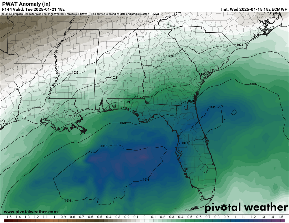
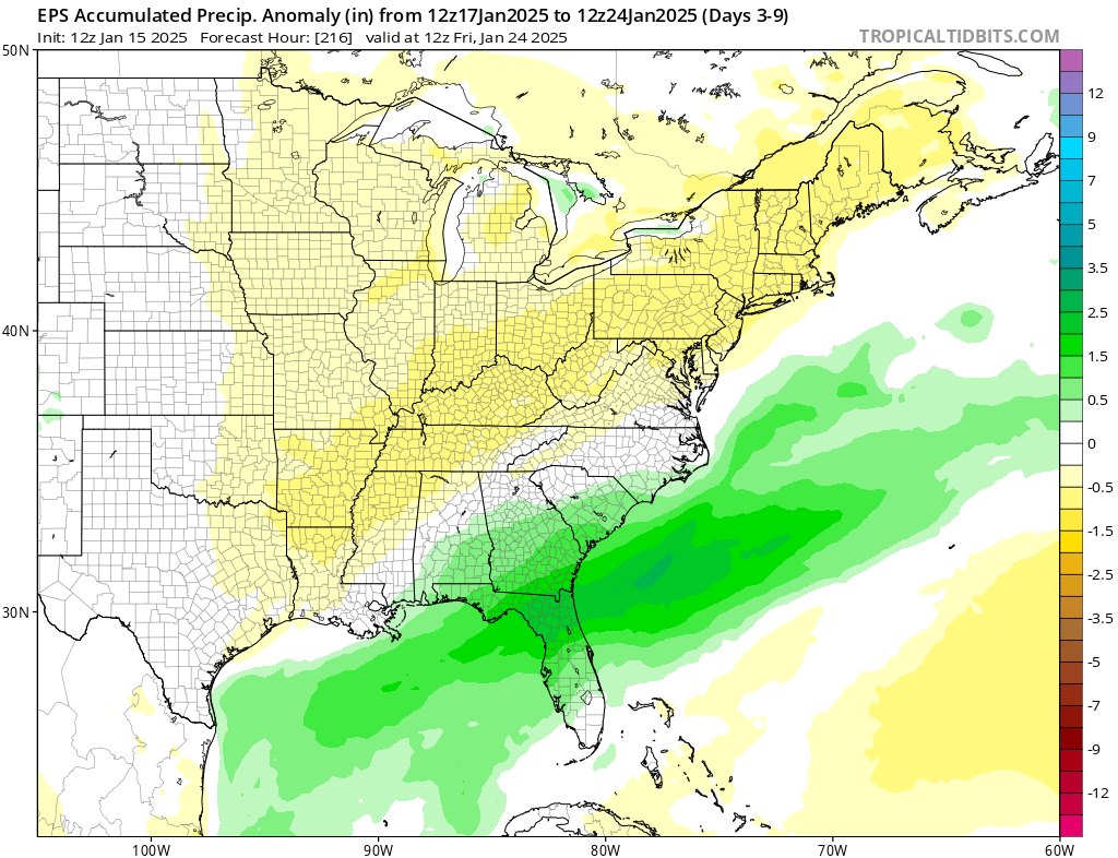
I know I have used this graphic before, but when looking at the operational runs of the models, especially the EURO and EURO-AI the trend shows Central MS into TN being on the drier side. For reference, the PWAT anomaly is also posted and they almost overlapped perfectly at this stage of the game. The main concerns that the models are focusing on will be the southern AL/GA/FL and possibility SC. Not sure what the GFS is doing at the moment as it looks to be the odd man out.
If the trends continue to go this route, could see a historic winter event across the Deep South. All of this is based on location of the sfc Low, timing of both the precip and temp. I think by this weekend we will have better idea and hopefully the models get their act together as well.I am also really conservative when it comes to winter weather it is one of the most difficult things to forecast and it takes 1 deg to make a difference between precip type. But given the data at hand, if I am along the coast, I would be watching this system very closely. I am just not sure how far north the winter precip will extend. I think that is where the uncertainty is at in all of this.
Got a great friend who is from Jackson, MS. Glad you got your red tag!
-
3
-
-
When we see ensembles at 144 which are below zero (actual temps), we are dealing with significant cold.
-
5
-
 1
1
-
-
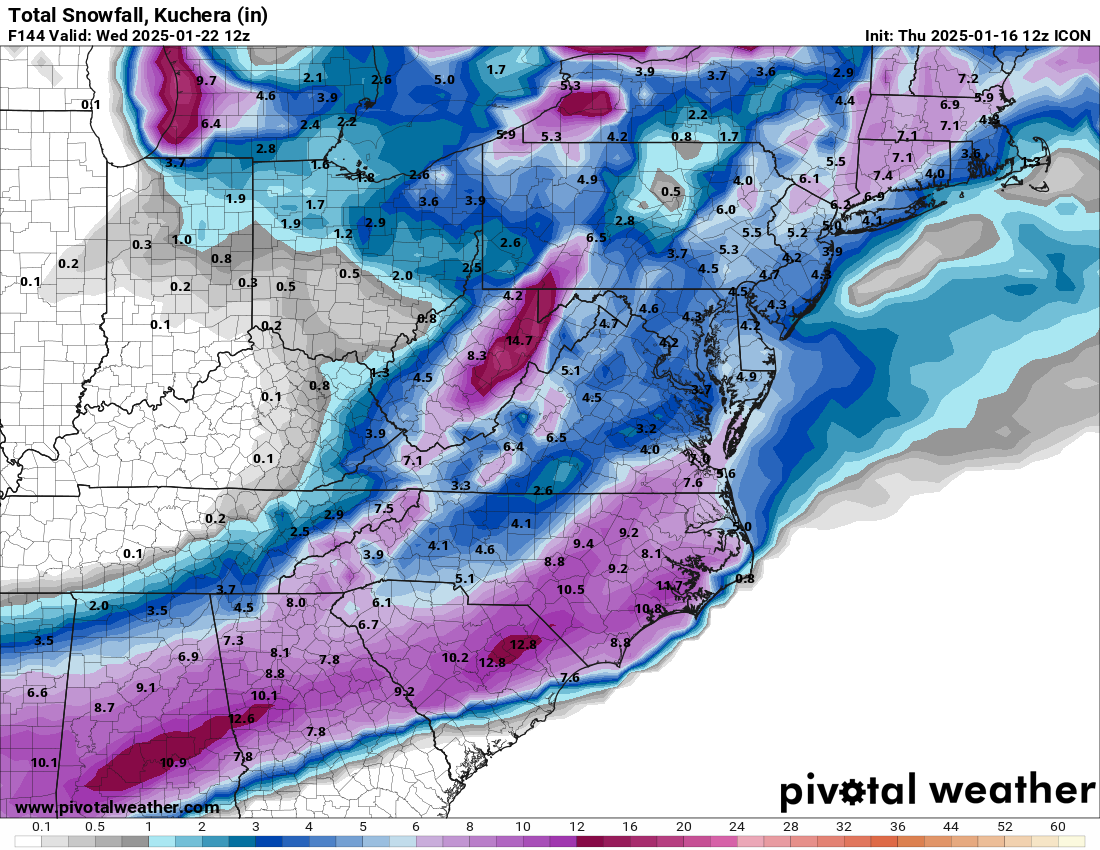
The scenario is there for this to be more than one.
-
9
-
-
The 12z kuchera for the GFS is no joke, folks. I still think this Sunday system is causing some problems or maybe is a symptom of the problem. How the jet buckles is going to be key. The CMC, as Holston noted, went with wave 1 after Sunday. The GFS held back and caught the second wave. Yeah, sounds like surfing...sorry.
-
6
-
-
10 minutes ago, matt9697 said:
We were on the outer edge here in Sumner county. I can only imagine what it must have been like to be in the thick of things. I remember it because was the only time I have ever seen snow fall in sheets from the sky and what fell was being blown around so much it was really hard to know how much had fallen.
Went driving with my friend Bill C from Powell (@PowellVolzmight have known Bill). Bill passed away recently. Bill had a yellow jeep. We drove out in the middle of that storm. It probably wasn't the wisest of moves, but I was in college and didn't know better. That said, the wind and the snow was something like you would see at higher elevations. The snow was almost like a mist.
-
2
-
1
-

Winter 2024/2025 January Thread
in Tennessee Valley
Posted
I keep thinking it is going to warm-up. Both the 12z Euro and Euro AIFS are frigid w/ some minor warm-ups. MAJOR differences in how the MJO is being handled between the Euro and American modeling. If the Euro wins this battle, it is very possible this winter isn't even close to being done. If American modeling is done, gonna be mowing by the end of February...then the cold comes back! If we only get a minor warm-up, the 95-96 analog might be the ticket.