

Carvers Gap
-
Posts
15,665 -
Joined
-
Last visited
Content Type
Profiles
Blogs
Forums
American Weather
Media Demo
Store
Gallery
Posts posted by Carvers Gap
-
-
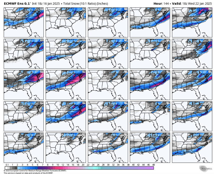
The CMC is on the west side of guidance, and its ensemble is west of that at 12z. Decent jog west on ensembles. GFS and its ensemble are still buried. The GEPS came in west of the operational at 12z. I noticed the ensemble mean was up (GEPS), and decided to look at the individuals. Most of the bigger solutions get portions of E TN.
-
 3
3
-
 1
1
-
-
The 12z Euro has below zero temps right in the middle of my February warm-up! If I was driving a car called the February torch...the warning lights would be coming on. BTW, it has yet another solution for snow next week.
-
6
-
-
1 minute ago, Daniel Boone said:
Link says "not found" brother.
^^^^^^^That's what happened to our snow -> 404 not found. Comedic drum roll please.
-
1
-
 7
7
-
-
4 minutes ago, Holston_River_Rambler said:
I think we decided to use it for subsequent obs for the arctic air too.
It's an all you can eat buffet. And what's even better? It's free.
-
1
-
 1
1
-
-
This is what we want. The Euro has a bit of a low amplitude bias at times...beware. But if we can get the MJO plot to race acorss the warm phases with low amplitude in the COD, February might be in play. I did have NOT thought that for several months. This trend started to show up recently. The EPO/PNA is showing that is really wants to stay in place. The NAO is showing some weak signals that it might fire up again soon. Remember, the NAO is one of the toughest things for modeling to model IMHO, especially when it initiates and duration. @GaWx, is phase 3 the North Carolina phase for snowstorms?
-
1
-
 1
1
-
-
2 minutes ago, matt9697 said:
This is different from the previous? Showing less of a stout shot of cold air?
Nah, February was supposed to be a torch. Models have been slowly backing themselves out of that torch solution. That look isn't warm at all. Cold source is good, and that ridge in that PNA can deliver it.
-
3
-
-
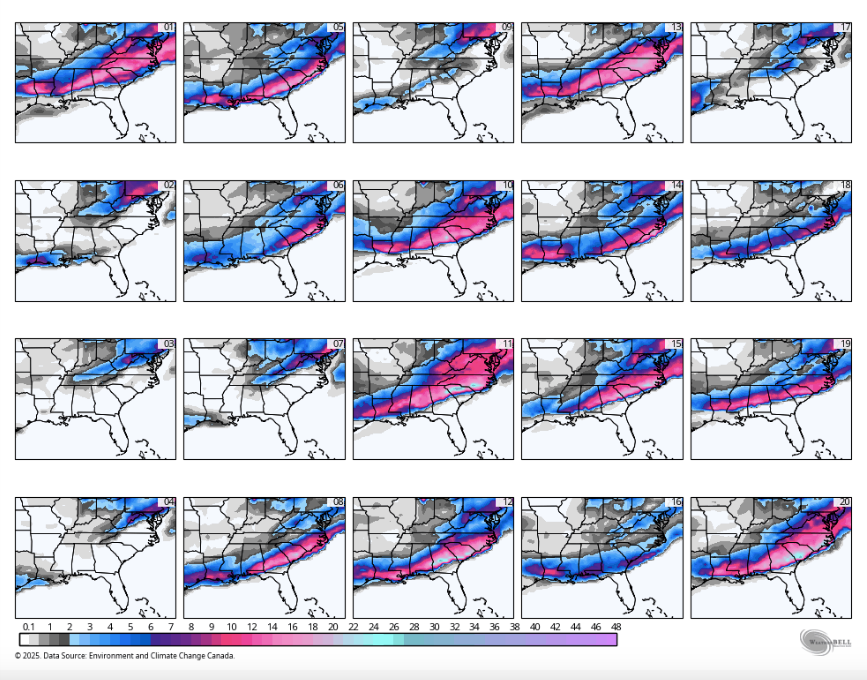
2 hours ago, Holston_River_Rambler said:
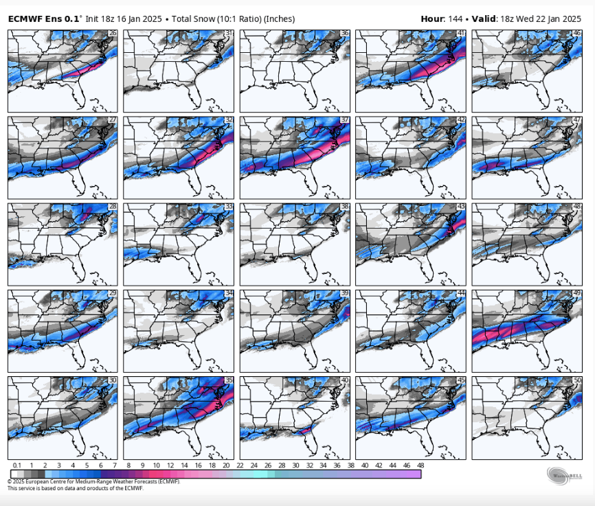
Did everyone actually look at the snow output on the CMC last night for next Tuesday- Wednesday? I know we've been mentioning it, but it is worth a look if you didn't see it. It was insane.

47.
point.
7.4.inch.
max.
It has a really bad habit of overdoing it for the Carolinas. Remember that 4' storm which never materialized there? I still have a friend mad at me for sharing that map! LOL Now, if it wants to move that northwest a bit....then of course it is legit. LOL.
-
2
-
-
Well, well, well....
-
2
-
2
-
-
The trend is our friend.
-
1
-
 1
1
-
-
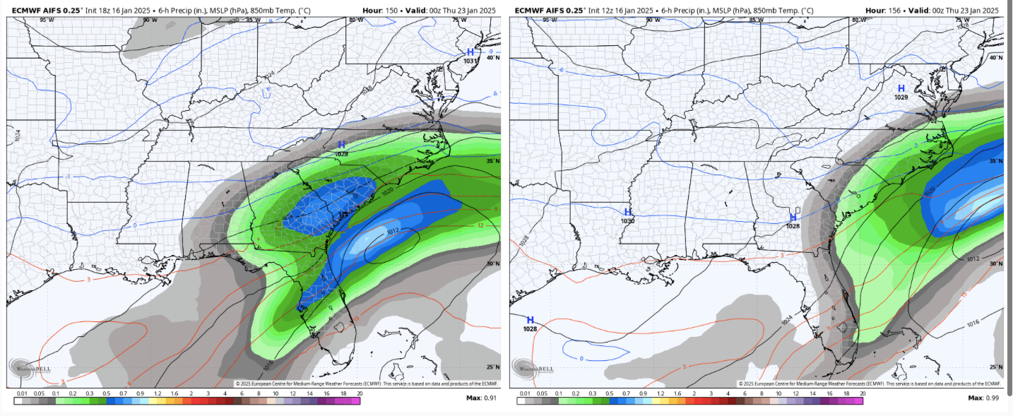
There wasn't even a straggler on 0z that I could find. 49 looks realistic to me. 35, 8, 3, 9, 16 as well.
-
4
-
-
There are hits on the 18z EPS for individual members. There were zero at 12z. Major trend north with individual members.
-
2
-
-
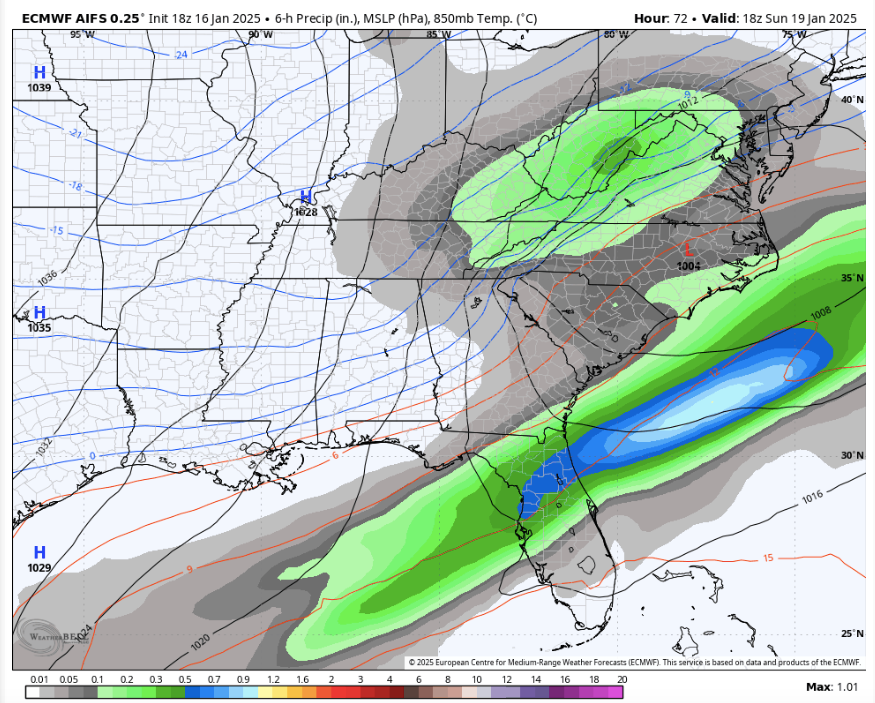
AIFS for Sunday....trend for mid week.
-
3
-
-
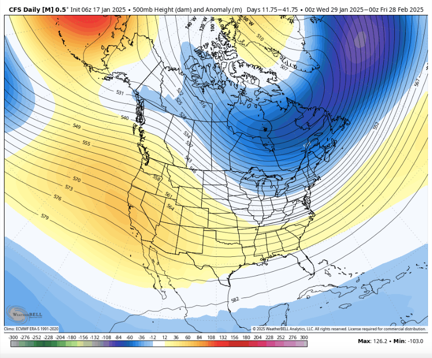
What is crazy is that if we manage to bridge three weeks in Feb(weeks 1-3) with even normal temps(instead of AN temps), we might be able to string together a pretty stretch of winter that lasts into March. I do agree, however, with those saying this might snap to spring at some point. That said, this winter has been troublesome since I first started looking at it over the summer, and said as much. It is no less troublesome now!!! I like these types of patterns BTW - tough! That smaller bank of cold analogs has had a say. I really want this winter to have some 14-15 in it...not sure that it will, but I'd like to see it. We have things working for us right now that we normally do not. Mainly, there is a lot of cold over NA and stays that way. I kind of thought next week might be it....I am not so sure now. The MA has a good post of modeling correcting the trough eastward in the LR. The EPO is possibly positioning itself to be the main driver for this winter. A good EPO pattern during February is often money. We aren't there yet, but let's see if we can steal a month.
-
1
-
1
-
-
@Daniel Boone, this might be one of those years where we need some SER to fight these wicked strong cold fronts. Complete opposite of recent winters.
-
1
-
1
-
-
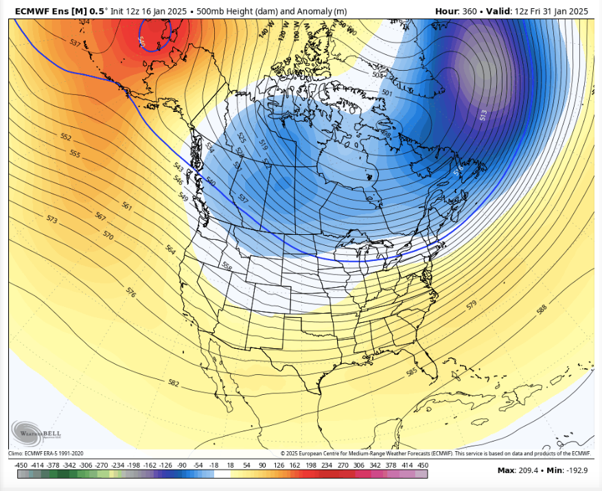
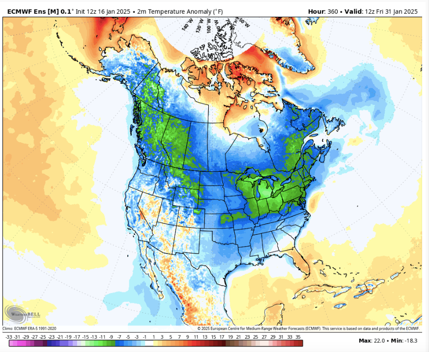
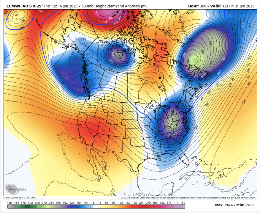
Check out the 500 pattern at 360. Then check out what is underneath. This is supposed to be the warmup. Again, I would caution that the EPS is handling things differently than the GFS/GEFS. The GEFS still has very cold temps in Canada.
-
3
-
-
The one thing I am noticing is that even when ridges roll through in the d10-15, the source region is so cold that any trough(caused by a cutter) injects bitterly cold air into the eastern US. That seeds the next storm. It is a pattern where we could potentially have slightly AN temps(really warm days and really cold days...not in between), but be a wintry pattern. There are still below zero temps in the Ohio Valley after storms cut. Maybe the key @BNAwxis that source regions are actually improving as the month closes.
-
2
-
-
Sorry for the flurry of non-storm related posts, but the striking thing that I am seeing is the eastern Pac has a ridge over it. That sure seems like the PDO may be about to help. IMHO, it trumps all cards. Maybe that transition is already occurring as evidenced by the persistent EPO ridge. I doubt modeling is taking that into account yet.
-
1
-
1
-
-
4 minutes ago, BNAwx said:
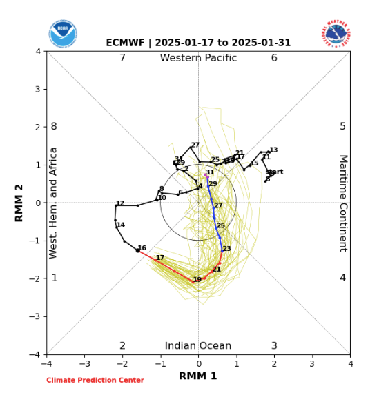
This seems to be one of those rare winters where it seems to find a way to stay chilly in our neck of the woods. Hope the Euro’s MJO forecast is right. It looks like a quick low amplitude run through the warm phases then into the COD. My gut feeling (and it isn’t worth much) says we’ll have several more chances at winter weather before we make the final break into Spring.
JB had a good article(unrelated to what I posted above) about the MJO starting to collapse by d15. That would be huge as that means it would collapse as the MJO is rotating through the warm phases.
Me talking now...I am not totally sure, but background warm phases are not necessarily antagonistic to snow here. I think we see some ridges roll through. The ensembles are warming back to normal by the last three days of the run...but a red flag to me when look at LR models is if the operatationals are totally the opposite. Normally, we see the opposite it seems. We are anticipating cold due to cold ensembles. However, the operationals never really cool down - red flag. Maybe we can steal some cold in February. If not, the analogs for this winter really point to a cold(maybe very cold March).
As for severe, and others have mentioned it. It would not surprise me at all. With such extremes in air masses along w/ changing wavelenghts, it would not surprise me. Any SER is gonna be trouble.
-
2
-
-
The short range is giving me a headache. LOL. So, here is some fun stuff.
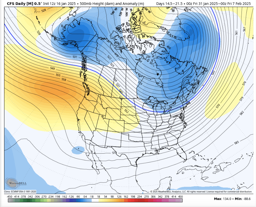
Check this out for the end of the month. The first image is a single, day image of Jan 31. Look at the CFSv2 for Feb1-8th at 12z. That is uncanny. I am coming close to using the AIFS as my main LR tool. It has been stellar this season at picking out cold in the LR. Why do I show these? Well, the Weeklies have the trough in the West! Now, there are all kinds of conflicting teleconnections in these images. Cold Alaska w/ a weak PNA or EPO. It looks like Greenland is helping out some. Maybe the strat is starting to wreck havoc on a warmup for a change! We'll see. I do think we see warmer temps than January, but there is no where to go but up! So easy call. Inject some cold into February wavelengths, and we might not be done. If these are wrong, I am getting my lettuce out early! LOL. PDO wildcard in play.
-
3
-
1
-
-
I keep thinking it is going to warm-up. Both the 12z Euro and Euro AIFS are frigid w/ some minor warm-ups. MAJOR differences in how the MJO is being handled between the Euro and American modeling. If the Euro wins this battle, it is very possible this winter isn't even close to being done. If American modeling is done, gonna be mowing by the end of February...then the cold comes back! If we only get a minor warm-up, the 95-96 analog might be the ticket.
-
2
-
1
-
-
1 hour ago, nrgjeff said:
Y'all are starting to sound like me! Welcome to the Dark Side.
AI versions pretty much followed their ops versions. Whatever. I'm going with the Canadian. Sounds good, eh?
I want "Chattanooga snow Jeff" back!
-
1
-
-
3 minutes ago, PowellVolz said:
Parts of North Central NC saw their first accumulating snow fall in 3 years on this past Friday. I understand parts of SC going snow free for a while but it’s crazy to think that it’s been 3 years since areas on the NC/Virginia border has seen snow. I just always assumed that area wasn’t prone to snow droughts.
Super similar to NE TN. We aren't in a snow drought here, but many areas are in a "big storm" drought. NE TN normally cashes into a big storm from time to time. I think it is La Nina weather patterns - drought city there and here.
-
1
-
-
5 minutes ago, PowellVolz said:
Since this is the most used thread as of now I’m going to drop this Pivitol Weather update in here and let a mod place it in the appropriate thread. I’m putting here to give everyone an opportunity to see it for now.
https://x.com/pivotalweather/status/1879926384421994786?s=46&t=LVg8BRWCh1zZb6F_t95EVg
So, I have finally learned how to post Tweets on this forum. It won't work with the prefix "x". Just take the address and put it on Word or Notepad. Take the "x" out and replace it with "twitter." Then, you get this...
-
2
-
-
I mean if you simply say, "Which one makes the most sense given the incoming cold?" It is an easy choice. Two model runs make no sense given climatology. Charleston snow once in a blue moon? Sure. North Florida snowstorms? Man, I won't be able to resist marching myself into the climate forum(please don't start discussing that here!!!!). E TN could sneak into this. That said, these systems next week definitely have a lot of aspects of a Carolina snowstorm. I remember seeing the thousands of posts when we were in the SE forum about their storms. This fits about all of the criteria need for snow for them.
But....every once in a while the E TN posters would reel one in w/ a northwest jog. It was pretty glorious. Those folks haven't had snow in a while, so I will go easy. But I am still hoping maybe we can reel one in across the Apps.
I think a big storm is possible. IF, we are looking at the Weds-Fri fram right now...remember modeling loses systems often between d5-8.
-
4
-
Winter 2024/2025 January Thread
in Tennessee Valley
Posted
The 12z GEFS has a trailer system (similar to the EURO) to the SE mauler. It is showing up on ensembles about 36 hours later. Decent hits.