

Carvers Gap
-
Posts
14,237 -
Joined
-
Last visited
Content Type
Profiles
Blogs
Forums
American Weather
Media Demo
Store
Gallery
Posts posted by Carvers Gap
-
-
Yep. Phase 5 MJO centered on FMA is cold. If the MJO above is correct, that isn't overly warm for mid-March.
-
 1
1
-
 1
1
-
-
2 hours ago, jaxjagman said:
The mean has been aiming basically skipping the cold phases for the longest time and dont seem to be backing down
.png.269cd8b8acedb4216fa414b864494fa0.png)
Isn't 5 a cold phase during March?
-
1
-
-
I don't know what the issue w/ LR ext modeling is. It may just be LR ext modeling is not great during Jan/Feb. I suspect modeling missed the IO/SOI/MC area forecast. The anomalous GOA slp during December was not great. I also think the NAO is terribly difficult to forecast at any range, and that was a big miss. The NAO could have given us a chance for cold later this winter. When modeling lost it....flipped warm. So, I think the combo of difficulty in modeling the NAO and also MC regions modeling failures caused the bust. The strat split miss probably didn't help. Guessing we also have an ascending QBO and declining El Nino. Again, not all El Nino winters are cold and stormy. We thankfully got a decent, little window. But the 90s El Nino winters were hot garbage with the exception of a couple of really notable events. And honestly, outside of last winter, three of the last four winters have had some decent winter weather to track for at least some portion of the forum area.
-
6
-
-
58 minutes ago, PowellVolz said:
I always kind of enjoy watching shortwaves during spring, especially for the mountains. Back when I lived in JC, those little shortwaves could leave 1-2" of snow on northwest facing slopes. I think we get one more window for those somewhere during the last 2-3 weeks of March or early April.
-
3
-
-
Speaking of snow, I do think folks above 2500’ could see some snow Sat morning, maybe even some snow showers at lower. MRX mentioned light snow for higher elevations.
-
4
-
-
7 hours ago, Itryatgolf70 said:
It won't matter except higher elevations if it even gets cold and snows. Always the exception I suppose. A true mjo phase 1-2 models willing definitely adjust.
One thing about this forum, not every post after winter is over is about snow. For those of us having to sit through youth outdoor sporting events....that exact comment that I made -> matters. So yeah, it kind of does matter, and that is exactly why I made it. Could it snow? Sure. But anomalous cold during March and April is worth a discussion whether it snows or not. We keep this place moving year round. It isn't all about snow.
-
6
-
-
Have a feeling March 10-31 could be pretty cold. Euro Weeklies control was crazy cold this afternoon. It has been a pretty decent indicator of cold this winter. It was the first to catch the late Feb bust.
-
3
-
 1
1
-
-
3 hours ago, nrgjeff said:
Epic model failure! How a cold forecast goes torch. I'm out until spring severe. Except Banter, always college basketball.
Think there was some bad data inputed into the model or just not explainable? The problem that I see is that the Euro Weeklies still look like they have the same cold bias (same exact setup) from mid-March to early April.....wondering if that is the same, false signal????
-
2
-
-
@Holston_River_Rambler, bowling ball around 300 on the 18z GFS. That will actually work - rain for that solution, but a stalled or slow rolling bowling ball is a good solution.
-
4
-
-
Found it. 1992. @Daniel Boonelooks like another stalled (or close to it) slp along a sharp cold front. My apologies to everyone w/ this -> This was early May!!! LOL. Just having some fun. Most of the snow fell above 2000'. Mt Pisgah had 61" of snow. That is mind boggling, AND they dealt with mixing issues at times. I do know that Beauty Spot near Newport can get absolutely hammered during March. Again, sharp cold fronts can produce at times.
Another great write-up...
https://climate.ncsu.edu/blog/2017/05/remembering-the-surprise-spring-snow-in-may-1992/
-
2
-
 1
1
-
-
1 minute ago, Daniel Boone said:
Yep. Remember it well. Did have Pics of it. It started on Thursday the 2nd and ended Sunday the 5th. I took Pics each Morning of it. It was constant steady Snow the whole period. It was simply amazing. The LP did as you said and then got cut off from the flow and became a cutoff Low over the Southern Apps. It was raining in Detroit and Buffalo while snowing here. There was no drifting in the Valleys, just straight down Snowfall. I remember it being in the 70's for a couple weeks before that. So ground was warm. I remember sticking my hand through to the ground and it would be wet underneath. I had about 2 feet on ground at deepest near Pennington gap. A Neighbor had a junk car parked on North side of his home and there was 30" on it. WCYB reported a report from High knob near Norton of 54".
I edited the Apps runner part...should read textbook Apps snowstorm.
I liked snow, even then. But I have to admit, that maybe was a bit much given that my entire spring break was stuck in the house. And yes, the snow was a paste job. Man, 54"?!?!?! That is insane. Yeah, I don't remember the run-up to that storm even being remotely cold at all. It caught everyone off guard.
There are a couple of Pisgah storms I am going to have to look up later. They were during the early 90s or late 80s. They may have been back-to-back. This spring kind of has that feel where a well-timed cold shot could cause some mischief. I wonder if we dig back through met records if we find an SSW lurking in the shadows of one or all of those storms.
-
2
-
-
32 minutes ago, Carvers Gap said:
This is one which actually rivals 93' but gets a little less press. This was my spring break in HS. We couldn't leave the house for the entire break - snowed in. Folks raised in E TN, E KY, and SW VA know to keep looking back over one shoulder. Now, I am in not forecasting this, but LR ext modeling is showing cold worthy of this type of storm. It can and does snow at lower elevations in many areas during March and sometimes April, though this is an extreme example.
This is a great article about the storm.....It includes synoptical set-ups and photos.
This got shuffled to the previous page along w/ some other great content by forum posters(go back and read all of it). This is just kind of interesting from a hobby perspective. This is an early April winter storm that began w/ a slp in the Lakes (yep...a low in the Lakes), trailing cold front that hit the GOM, and a slp that climbed as an inland runner. Really, it is a textbook Apps snow storm that began as a wave along a strong cold front. That is one of the reasons that I watch strong cold fronts during spring.
-
2
-
-
This is one which actually rivals 93' but gets a little less press. This was my spring break in HS. We couldn't leave the house for the entire break - snowed in. Folks raised in E TN, E KY, and SW VA know to keep looking back over one shoulder. Now, I am in not forecasting this, but LR ext modeling is showing cold worthy of this type of storm. It can and does snow at lower elevations in many areas during March and sometimes April, though this is an extreme example.
This is a great article about the storm.....It includes synoptical set-ups and photos.
-
2
-
1
-
-
I suspect we have at least one more storm thread, maybe two. I could be wrong, but let's see. I don't think we are out of the woods until the first week of April is over. Plenty of warm embedded, but very strong cold shots are also prevalent. Wavelengths are shortening, and bowling balls are showing up. The 12z Euro control shows the potential w/ two separate winter storms during March. The SSW is going to have to be reckoned with. Late March is nasty on LR ext modeling. It easily could be a mirage, but oof...
-
1
-
-
If forced to make an early call for next winter, I would go:
Sept/Oct: Very hot and dry...w/ a flip to cold in either late Oct or early Nov
Nov/Dec: Cold w/ chances for multiple winter storms
Jan: Flip to warm...better chances further west in the forum one goes.
Feb: Warm
January is what I can't wrap my head around yet. It could be very cold and linger into early Feb. Some weak Nina analogs do that. At this point, I don't think we are fighting the QBO, but we will see (not a certainty yet). Or it could flip warm and never look back. We need to really be able to see the duration of this Nina. If we start moderate and move back to weak as the winer progresses, that is going to make this really, really complex. A weak ENSO state is almost always to our advantage. We might not have those answers until early summer at the earliest.
-
1
-
1
-
-
Just now, Itryatgolf70 said:
I'm still somewhat intrigued in how the SSW plays out to see if we have one last big cold blast here. Not your typical niño this winter like many have alluded to
I think that has merit. My guess would be western North America and then maybe it slides eastward. There are still some big cold fronts showing up on the GFS. Usually when winter is over, you don't see those cold fronts on LR modeling. OTH, it may just be cold and rainy. The Euro weeklies have hinted at a second-week cold shot. There is definitely some warm weather in between those cold shots though.
-
1
-
-
1 hour ago, Daniel Boone said:
Yeah, next Winter is a bit murky as like you said, if the Nina is weak it can be a whole different ballgame.
January cold this winter (second half) was very predictable and fit seasonal norms to a T. Next winter, there is a A LOT going on. The strength of the Nina is going to be key. If it is moderate to strong...no dice for eastern areas. Some of our best winters are weak La Nina winters w/ a falling QBO. The QBO should at least be descending by next winter even if positive. The toughest thing about Nina winters is trying to sync cold w/ a weaker STJ. But who knows, sometimes winters can buck climatology. I think next winter has far more uncertainty. We are definitely in a base Nina state right now. I do expect the continent to be quite cold which means it will likely get very cold in eastern NA at some point.
-
1
-
-
And one last note, the TN Valley has always been home to extreme weather, especially flooding and drought. TVA has steadied that quite a bit, but it was rough prior to TVA. There have generally been wild swings in TN for at least the last 150 years. Our latitude is almost always problematic. We live in the subtropics and that is always important to remember.
-
2
-
-
1 hour ago, Matthew70 said:
I feel like nature is hard to predict these days. Seems everything is reverse of what it should be. This winter was to be a backloaded winter & instead we had 1 week in mid January. From MJO to teleconnections we keep adding or finding something that affects the weather patterns. I remember in the last 2 years it was supposed to be a hot dry summer when it was the opposite. Nature sure is bipolar! Lol.
7-10 days of winter is actually very normal for this area (not higher elevations). The record snow in Knoxville this year and record number of snow (4"+) w/ snow on the ground is telling. As for backloaded, it was close. If the storm had arrive about a week later, that would have been backloaded. Technically, it hit right in the middle of met winter. The main part of winter came during mid-January which is prime climatology. Many places at lower elevations are at or above snow norms. When we get a really severe cold outbreak like that, winter will often end - even if December. That has happened more times than I can count. The only surprise to me this winter was the anomalous slp in the GOA which brought the monster chinook to Canada during December. That probably delayed the cold about 1-2 weeks after Christmas. February has been warm, but the Nino really has collapsed, or is collapsing. Plus, we could still see more snow. We have about 4 more weeks where it can snow in the valleys(increasingly problematic w/ each passing week). I don't really see anything on the horizon right now, but there are some decent windows.
As for predictability....it is always tough, but lean on ENSO and you will often be right. I learned that from our mets here.. I managed to get 3/3 for DJF temps last winter. This winter I have 2 out of 3 for DJM - Feb will obviously bust. That is far above what I am normally capable of in terms of temps. Normally, I am much, much worse than that. It really is a crapshoot. I share that to say that predictability has been not bad. Next winter is an entirely different animal in terms of predictability - going to see some seasonal busts next winter IMHO. One other surprise is that the mountains/foothills didn't get more snow, but....that may also get rectified at least for the mountains. There were some BIG late season snows in the mountains during the 90s.
One thing to note, there were some El Nino winter analogs which were not good. Some were really good. This winter was kind of a mix of the two. So, really having a historic snowstorm for many areas equates to a good winter for me. I do think next winter will see continued bouts of severe cold, especially middle and west. The fact middle and west scored during a Nino is a HUGE bonus.
-
2
-
-
2 hours ago, Daniel Boone said:
I'm with Carvers. Everything I see is pointing toward a hot, dry Summer. Imo, the only caveat may be if we're fortunate enough for TC activity to bring us beneficial Rains. TC development will probably begin early as Holston pointed out Factors arguing for a very active Season and the already very warm SST'S of which would favor that early start.
Tropical activity can definitely mute temps. I think we might see some early tropical activity, a lulll, and then a tropical activity to end the heat during.....mid-late October. I would guess Nov-Dec would be seasonal to BN for temps before the Jan-Feb torch next winter. Though, I will say that if Nina is weak....it could be colder. I am still a bit torn on next winter. The QBO may be set to drop during later winter.
-
2
-
-
The 12z GFS continues to get colder.
-
2
-
-
The second half of summer (or maybe all of it) and all of fall could have significantly above normal temps. In NE TN, drought can be excessive during La Niña. Sometimes middle and western areas will dodge that drought and get the opposite. Hot and dry as the summer progresses and into fall.
As for spring, I think we see a Nino hangover with rainy and cloudy conditions for the first half of it w some sharp cold snaps - almost winter like at times. Depending on when the atmosphere responds to the likely Niña, will depend on when it flips to the furnace - could be May or could be late June or even early July. You will know it when u see it.
-
2
-
-
1 hour ago, Itryatgolf70 said:
March can provide ULL that produce snow, which have been the biggest snowstorms every here in my area during March. If we don't have a cold connection, it don't matter at that point.
So you are saying that you don't like the cold rain ULL version? j/k LOL
-
1
-
 3
3
-
-
Decent little leap year anafront on the 18z GFS. It has been flirting with that for several runs. The gfs has had some strong cold fronts during the past 4-6 runs of that model. Reminds me very much of models finding the Jan cold shot.
-
4
-

February 2024 mid/ long range
in Tennessee Valley
Posted
Good post.
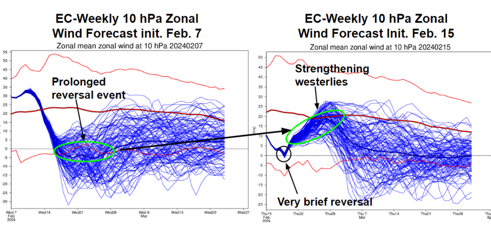
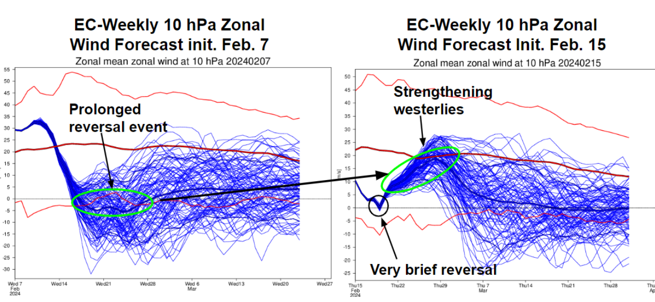
I think there is an error either in programming or data input right now which is resulting in a LR ext bias (across modeling) for cold during weeks 3-4. I can't put my finger on it. What shows up is a double block (NAO along w/ PNA or EPO), and it is not verifying or even coming close to verifying. LR modeling has been pretty decent since last Feb...until this past late-Jan. So, I wonder w/ the changing wavelengths if modeling just can keep up during spring shoulder season?
I do wonder if data input is a problem - meaning modeling cannot keep up w the collapsing El Nino. In other words, SSTs are changing so quickly that modeling is in constant "catch-up" mode.
But yes, HUGE grains of salt for anything during weeks 3-4(cold or warm) right now. I did notice the Euro ext control and ensemble on the Euro LR ext did get out of sync prior to the temp bust...controls flipped back warm and caught the Feb temp bust very early in the process.
As for the MJO, I don't think the signal is super clear...at least not clear to modeling. It is very low amplitude on the CPC plots this morning. And while phase 8 is cold during winter, by late March...it looks exactly like what we have in regards to temps across the lower 48. Also, doesn't the MJO have less influence during March as well?
Anyway, this is the look(below) that has been in the LR for much of Jan and Feb, and hasn't verifying. The GEFS ext is a bit more realistic w/ a transient NAO(which has been the pattern this winter) vs one which locks in. IF(huge if) that verifies, that is a ver wintry pattern for higher elevations...but like you, just not sure I buy it.