

Carvers Gap
-
Posts
14,237 -
Joined
-
Last visited
Content Type
Profiles
Blogs
Forums
American Weather
Media Demo
Store
Gallery
Posts posted by Carvers Gap
-
-
What a beautiful day.
-
 3
3
-
-
The 12z GFS has been cooking something up around 240...GEM has that to some extent. Cold shot w/ various waves. Holston is on top of it as usual! Worth watching at least for the mountains of E TN.
-
4
-
-
1 hour ago, Daniel Boone said:
Yeah, mentioned that in a post above. Actually killed the Leaves on the Trees. May 2007.
That is the year. I must have not been reading closely!!! Once we get over 50, all posts look new anyway! LOL j/k - sorta not. I don't know that we actually got full leaf coverage that year in NE TN. The trough looks over the eastern half of the country on the 12z GFS. The main axis looks over the NE, and fairly cool/progressive here. If that thing were to buckle, look out....
-
3
-
-
17 hours ago, PowellVolz said:
My memory is terrible but spring 2016, do you remember the overall pattern? We had a very warm March. So warm that I remember golf courses were almost green by the end of March and then we had about a week long freeze right around Easter that wiped out a lot of Azaleas, crept myrtles and fruiting trees. Hoping we don’t repeat that spring. (If my memory has the right year but I’m almost positive it was the same year as the GSM park fires).
.For now......it looks like the worst of the cold is over the Northeast. If a storm were to deepen along the Coast(even if it doesn't snow here), that would be a concern. The last two weeks of March have to be watched for cold. Overall, the Weeklies last night were much warmer for April. Those late season cold snaps are tough to predict....just takes one really strong cold front on the heels of a cutter or coastal along w/ some clear nights, and we could get a prolonged freeze even during a warm spell. Several years ago, I. remember the leaves on the trees up here getting bitten and falling off during maybe May?
-
2
-
-
Below is what the Euro Weeklies have been advertising for 3-4 weeks. This is now on the Canadian ensemble. That is West coast blocking connecting to Greenland blocking. This has been an error for most of the winter with the exception being mid-January. Let's see if this verifies.
-
4
-
-
28 minutes ago, Matthew70 said:
Of course. That’s TN springs anymore. Cold rains.
And yes, I think we tend to see SSWs head to eastern North America during spring.
-
1
-
-
24 minutes ago, Matthew70 said:
Of course. That’s TN springs anymore. Cold rains.
We really want to hang on to cooler weather for as long as possible w/ La Nina lurking. It has been my experience that if things warm-up during spring(during La Nina years), the summers are long and brutal. I don't see a long period of misery....more like cool shots, rain at times, and a strong cold shot or two. There is certainly a scenario there where it gets quite cold as ensembles being cold at this range can sometimes translate to much colder. Right now the cycle is....warm followed by step down to seasonal followed by step down to bitterly cold. Do we repeat that cycle one more time? IDK. But, I do think we are seeing a legitimate pattern change coming up w/ more troughing at least making its way eastward. The Mountain West is piling up snow, and they are going to need every bit of that water content.
-
1
-
 1
1
-
-
Pretty substantial cool down coming up in the d10+ and moving forward w/ time.
-
3
-
-
If you look at the 18z, you can see the slp crash into the Ohio Valley and a secondary form east of the Apps. Go look at those maps in the Feb thread, and that is what it looks like w/ one notable exception...the lee side stalls and doesn't progress northeastward very quickly at all. But the 18z GFS has that wonky setup....just too far out there to take seriously at this point. The 18z would put 1'+ above 5,000' in the Apps.
-
2
-
-
1 hour ago, Itryatgolf70 said:
What's interesting is the 12z gfs don't show it but the off runs do lol. Fun to look at it I suppose.
For the E TN mountains, I had a post in the Feb thread w/ the Pisgah and Spring Break storms. Those setups usually involve some sort of cutter into the Ohio Valley and a stalled, secondary lee side slp(sort of an odd Miller B). I am not saying that is what happens, but that is one of two set-ups that I look for. The other setup is a Miller A. The first scenario normally doesn't happen during winter, but stalled lows during spring are fairly common in the SE. They can occur as bowling balls or a lee side low that loses its steering current. The GFS has flirted w/ the first setup on a few runs. Kind of fun to track just for kicks and giggles.
-
1
-
-
1 hour ago, Itryatgolf70 said:
What's interesting is the 12z gfs don't show it but the off runs do lol. Fun to look at it I suppose.
I just think modeling is sensing potential...could be something, could be absolutely nothing. One of the interesting things about spring storms(if they arrive at night), is they will often over perform in NE TN. The Euro control LR extend(maybe yesterday or day before) had had something similar in that time frame as well. My guess is there is a piece of energy up stream that is potentially going to interact w/ a cold front. Timing is everything at that point. The best storms are often spotted at very long range...but I wouldn't say modeling has "spotted" anything quite yet.
-
2
-
-
18z GFS is not benign......some late season bonus runs by the American model today.
-
2
-
-
The 6z GFS (fantasy land) produces fairly significant winter storm 1'+ (12-17" of snow in some locals)for portions of the forum area. I won't add much more than that as it is pretty far out there, but that is right around the pattern change time frame, and worth at least a sideways glance from time to time.
-
3
-
-
1 hour ago, *Flash* said:
Here’s rootin’ for some wintry mischief in Monterey later this month. Just need one more snow in the air moment and I’ll be good ‘til next winter.
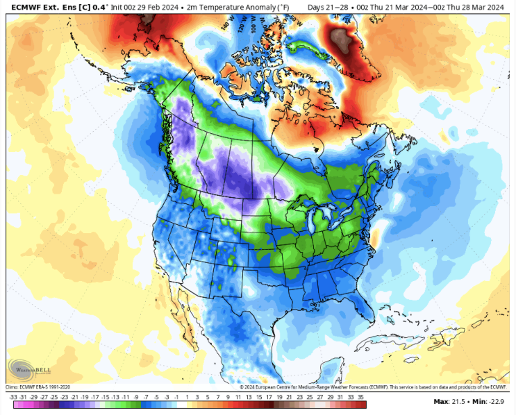
Best I can tell is that the pattern at 500 is set to flip around St Patrick's Day. We are gonna wish we had that pattern a month ago I think. We are kind of in that time frame where it missed last month, so proceed with caution. Looks cold. The 18z GFS tonight had a dusting to 2" of snow over the eastern half at lower elevations and up to 4-5" lollipops on the Plateau at LR.
-
3
-
-
Still a ways out there, but a pretty significant pattern change is now on d14-16 of global ensembles (not just LR ext models). To be fair, this is where it got last time, and it flipped warm. So, just that caveat. Overall though, that is a pretty cold look. I doubt that means measurable snow for many of us, but wouldn't surprise me to see some late season frozen precip in the air and maybe a dusting. Higher elevations have a legit chance at late season mischief if that is correct - anything above 2500'.
-
3
-
-
5 hours ago, Itryatgolf70 said:
Carver, do you have the early archived cansips from 20-21 through 22-23 niña winter to see how it did before winter started each those years?
I probably have them stored somewhere. It'll bounce around at this range. Seems like it did pretty well, though, during those years. It has a warm bias, but its 500 maps are generally about as reliable as one can get at that range. Still a very long way to go.
-
The one bug across most modeling of late is that weeks 3-4 have been too cold. I am not sure if that is due to an outdated analog package or if the IO/MC is wrecking havoc by firing unexpectedly. That is a recent bug which showed up in LR ext modeling during mid Jan(forecast for Feb). Honestly, this is also spring and we are in an ENSO transition....spitballing that is prob part of recent model inconsistency. Any transition caused model issues - seasonal, ENSO, NAO, etc.
I still think BN temps/seasonal for next Dec. Then, I think above for the rest of next winter JFM. If the Cansips is ever cold during winter, reality will often verify colder. Hot and dry for mid-late summer and early fall...then flip.
-
2
-
-
Cansips did really well for Feb. One error was a minor trough over the SE but it didn’t go whole hog. It’s MJO portrayal was pretty stellar - warm phases just looking at its Lower 48 temp profile.
Again, at this range...one won’t see details in the pattern. The overall DJF looks right. The DJF for this recent winter will be warm, but unless someone looks, folks won’t see Jan where record lasting snowfall was on the ground in Knoxville. The Cansips does have a warm bias, but one simply has to learn model biases.
And LR ext modeling missed only for Feb. It did well for December and January. 67% accuracy for at range is pretty decent...better than decent. Again, following modeling of chaotic energy systems is not for the faint of heart. The only way to get better is to use them. A lot of what we use (even though this is a public forum) is pretty state of the art. I am not going to use a Commodore 64 just because the new Lenovo is a bit buggy. The storm that we track during January...go look how far out we tracked that storm. We might have been tracking it from 10+ days. Fairly amazing at how far we have come in twenty years. Just wait until AI gets better.There are going to be modeling busts. I have been doing this a long time, and it is going to happen. That is just an understood variable with this hobby.
-
3
-
-
32 minutes ago, weathertree4u2 said:
With such a huge miss by long range modeling this winter, what is it about the model that would illicit any confidence? At this point, I dont trust anything outside 24 hours but I dont have as much experience at some reviewing long-range guidance
That is certainly your right to have that opinion. All modeling misses. That is like missing a free throw and saying, “Well, all of the next ones are not going in.” I will go back and look, but I believe Cansips was pretty close for Feb last month.
-
2
-
-
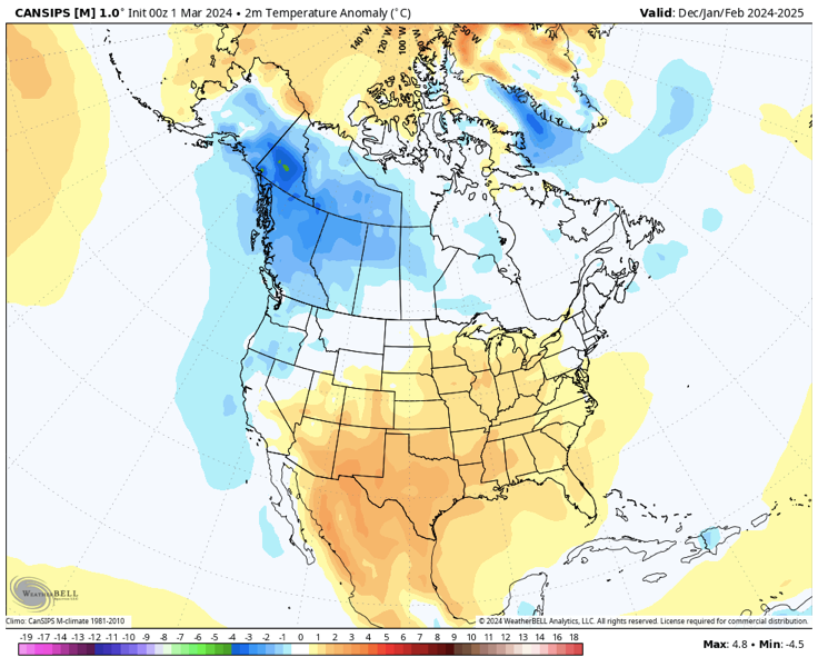
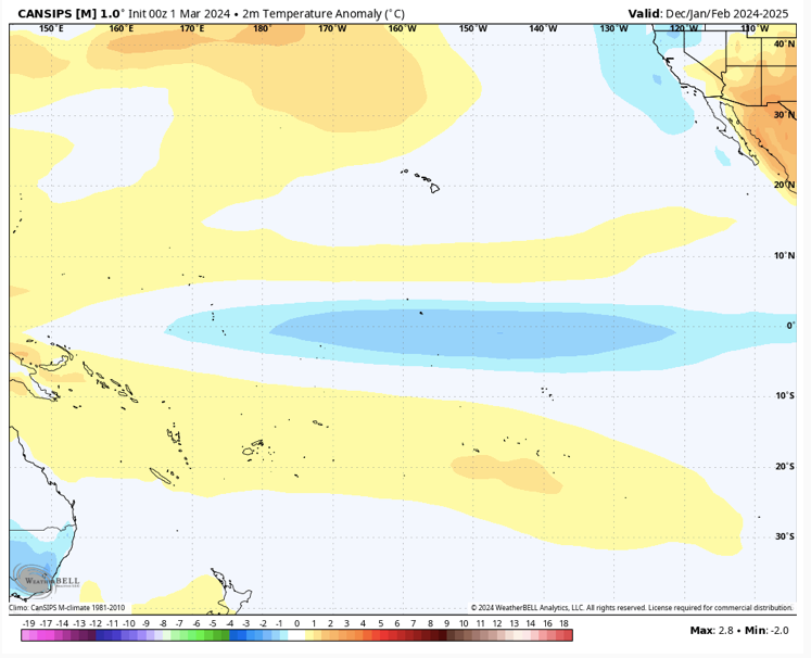
New CANSIPS is out. Here is the look for next winter. @Itryatgolf70, I have also attached the predicted seasonal DJF surface temp map for the Pac basin. Starts east based in Sept and migrates to central basin by December. Huge grains of salt as LR modeling almost always has a very warm bias. So, TIFWIW. Monster SER and Aleutians high are the staple features. The model really doesn't show a typical Nina progression for next fall/winter, but....I would guess some analogs are non-winters. The danger w/ stronger ENSO events is that winter never shows up, and we have been long overdue for a non west of the Apps. May need a whole heard of elk next winter. The Mountain West is set for a great winter next winter. -PDO features prominently. I would guess the compiled, overall DJF look is correct, but the progression of how it arrived there...not right. That progression is critical for how our winter looks here.
Summer starts cool and ends hot...but that really isn't earth shattering stuff, right? I need to go back and look at precip.
-
3
-
1
-
-
On 2/29/2024 at 9:29 PM, Daniel Boone said:
Truckee California : https://www.tahoeweathercam.com/mthardware.html
They are getting hammered on that cam right now.
-
3
-
-
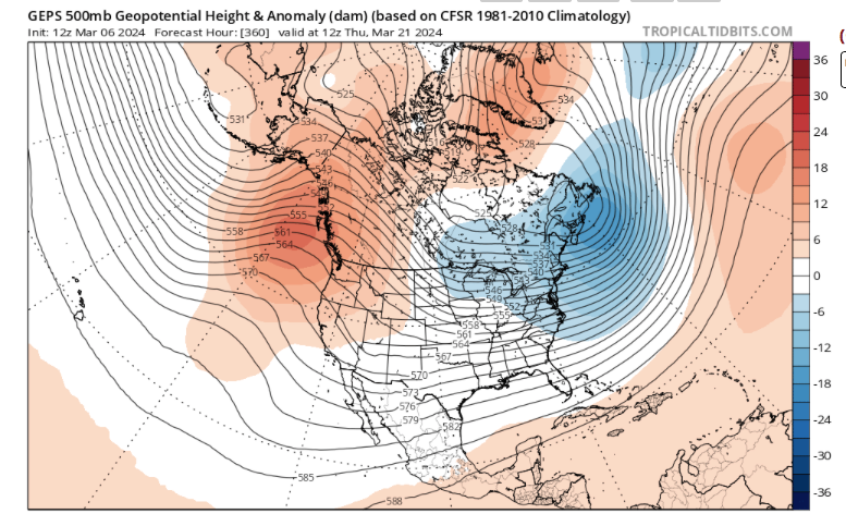
This is what I am looking at...Listed below are 4 maps. Two are week 4 control runs (GEFS ext, and Euro LR ext), one is a week 3 ensemble (GEFS ext), and the last is week 3 (Euro LR ext control). I have been watching this time frame for several days(prob weeks). Due to "mission fatigue" on the forum, I have held this timeframe a bit closer to the best than normal. However, with the operationals run beginning to hint at this, it is worth noting. Note that Canada is very cold. Certainly, we could get the rugged pulled out from under us. It has occurred at this range just a few weeks ago, but this signal has been very steady and fits with the pattern cycle.
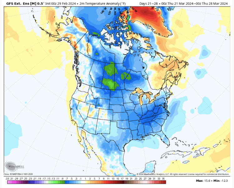
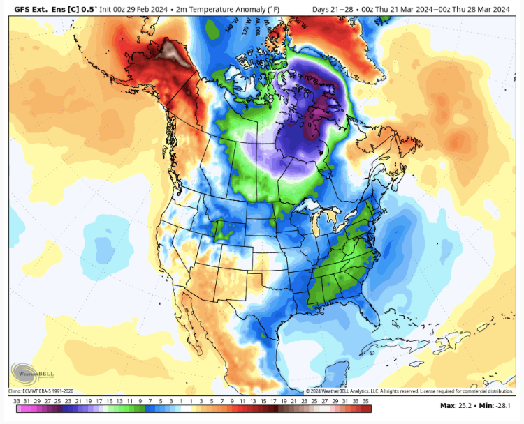
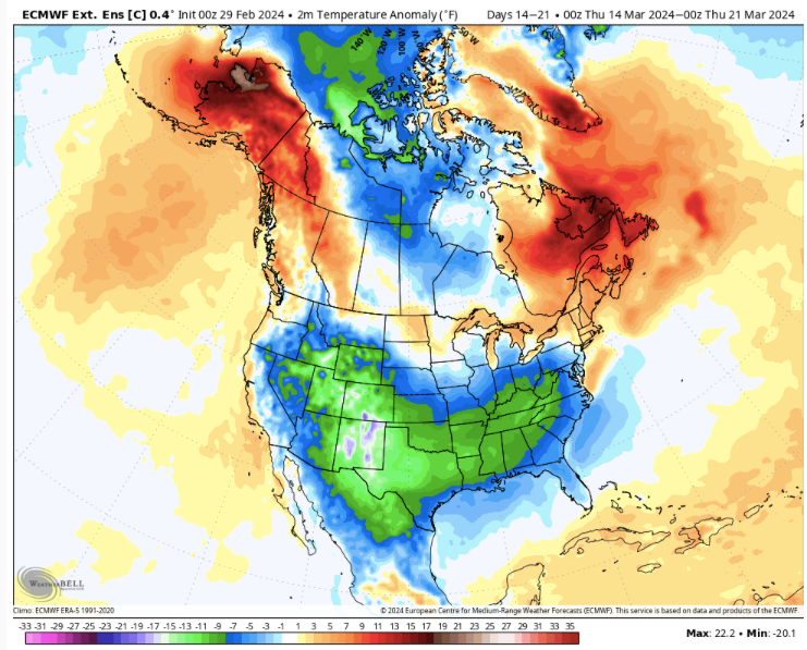
-
3
-
-
And as a reminder, the 4-6 week pattern cycle window (been warm) closes within the next 10 days. You can see the pattern shake-up on both the GFS and CMC at 12z. Now, I don't claim to know what the next pattern cycle holds. I do suspect that March 10-31 should be more interesting than the last six weeks. I won't rule out cold and wintry weather. The 12z CMC provides an example of where this could lead. The Euro LR ext (control) has been fairly adamant of an anomalous cold shot during the last two weeks of March. That control has been pretty decent this winter and now early spring.
-
3
-
-
14 hours ago, Itryatgolf70 said:
The Feb outlook should be available soon. I feel that based is more important than strength imo. As crazy as this sounds, we want a +qbo and higher sunspots. Typically, they can correlate with cold patterns. They do better with niña usually if they set up.
When in doubt, ENSO state and strength generally rule the roost in my experience. Solar max does certainly play a part in the weather. In fact, I believe that volcanism and solar are the two biggest drivers of our weather. I just don't think we understand those cycles very well because as humans we haven't observed them very long at all. Generally, it is pretty tough to find a decent winter where the QBO is not descending or in the negative range. As always, there are exceptions to many weather analog rules. One more interesting piece will be if the PDO does in fact reverse. Generally, I think we are at the beginning of a -NAO cycle during winter, and that will also play a part. The Nino location does play a roll in where the SER will set up shop. But generally a weak Nina means that the east based Nina would still be weak regardless of centering. Lately, it seems the IO is probably as big a driver as the Pacific...maybe bigger.
Generally, in order, these are what drive my bigger picture thinking:
Decadal indices or teleconnections:
1. AMO (easily the biggest driver IMHO)
2. PDO (very important when the AMO is not in a favorable state as it hasn't been since the late 80s)
Seasonal
1. ENSO state and strength
2. MJO...which really is an extension of the IO lately
3. NAO
4. EPO/PNA
(3 and 4 flip flop depending on which end of the forum one lives)
5. QBO which is probably related to 3 and 4.
6. When summer ends...extended summer generally causes problems for winter patterns as source regions in NA often don't get cold enough for long enough.
7. Recent seasonal trends(and maybe this should be higher up the list). The TN Valley will go through snow droughts, and when we are in one, nothing works...see many winters during the 90s.
For next winter ENSO, PDO, MJO, and NAO/EPO potential will drive my ideas. In general for MBY, I think winter starts early and ends early. That could be quite different for your BY this winter due to your location being further west. I am pretty bullish at this point for middle and western regions. E TN is a wild card, and that will depend on the strength of the almost certain SER.
-
3
-
1
-
March/ Spring mid-long range
in Tennessee Valley
Posted
The PV is spinning in the opposite direction of normal.
https://www.space.com/earth-polar-vortex-spinning-backwards-above-arctic-reversal-event?utm_source=facebook.com&utm_campaign=socialflow&utm_medium=social&utm_content=space.com&fbclid=IwAR0suogUmLsbHb98dCeLpcitxDzb5WMWimd91WXvLsnPbzOnCIpiooI8CB8