

Carvers Gap
-
Posts
14,237 -
Joined
-
Last visited
Content Type
Profiles
Blogs
Forums
American Weather
Media Demo
Store
Gallery
Posts posted by Carvers Gap
-
-
I am holding one card tight. Got to know when to hold'em and know when to fold'em.


-
 2
2
-
-
7 hours ago, PowellVolz said:
TYS…

.It was humming here too.
-
1
-
-
The rain today just looked like a sustained, high speed fog over the road tops today....reminded me of a gale I saw in coastal Oregon a few years ago. Pacific storms are just a different beast - so powerful.
-
1
-
-
Just now, Itryatgolf70 said:
Decent week of cold weather and a little snow was good, but hated to see winter end after that but we didn't know it yet lol
Better than decent. Half a foot in a winter storm...I take it over 4x2" snows any day of the week. Great run. Hate it had to end, but good run.
-
2
-
 1
1
-
-
This winter was substantially better IMBY when compared to last year....not even close. We had school systems closed for a solid week and deservedly so.
-
3
-
-
-
The wind is absolutely howling...non stop. Strong line of storms just to the west of TRI. Been a while since the wind has ripped like this IMBY.
-
1
-
-
And one more which is pretty cool...just move the slide:
-
2
-
-
31 minutes ago, Itryatgolf70 said:
Does anyone have or don't mind sharing the sst distribution maps for the 20-21, 21-22, and 22-23 niñas? Thanks in advance
-
1
-
-
10 hours ago, Holston_River_Rambler said:
I finally figured out what those sick ____________s did to my elk:
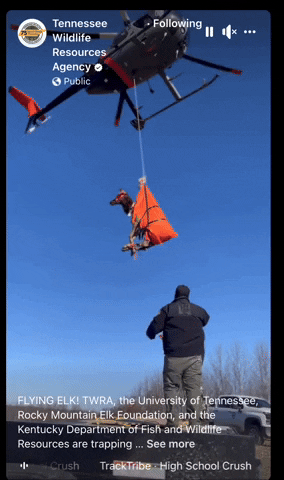
When the black helicopters show up, winter is over........
-
1
-
 2
2
-
-
5 hours ago, Holston_River_Rambler said:
For those interested in the astronomologer guy, I found his thoughts on the PDO. It was a reply to a Bastardi post:
Elk, metal snowman, wooly worm, and now.......
Jupiter.
Fun read. Interesting stuff.
-
2
-
-
1 hour ago, Itryatgolf70 said:
Winter is probably over except higher elevations like jaxjagman alluded to. My thoughts are already on next winter lol. Imo, if the niña is central based, or cooler in central pacific, game over for most except the west. If the niña, regardless of strength, is east based or cooler off peru, then we should see episodes of cold. Most niñas are front loaded. It was very surprising to see the -pdo as strong as it was this niño
We'll see, man. You may be right, but nobody knows the future. I have seen warm springs flip cold far too many times.
Agree on next winter.....but again, sometimes winters buck seasonal analogs. We are overdue a snowless winter - forum wide. Those do happen. But I think we possibly see a decent winter again next winter. I think we are in a -NAO cycle, and that will help.
With the PDO being a decadal oscillation, it doesn't surprise me that it didn't flip. I do think we are due to see it come up for air at some point. Hopefully that times w/ next winter, though there is no evidence of that at this point.
The Nina is showing hints of being centered over the dateline. Not a great signal at this point, but a LONG way to go. My money is on an early winter as well w/ maybe some NAO help and an SSW which we would need for the second half of winter.
All of that is assuming the ENSO state. A few years ago, they got the ENSO wrong(for winter) w/ the lead time being June of the same year....a single, volcanic eruption could change everything or even something we haven't thought of yet.
-
3
-
-
I will say this, one can make a pretty decent seasonal forecast for this area by using these tools -> ENSO state(nada is not good, but weak Nino or Nina will work), PDO, recent winter trends regarding NAO, QBO vectors(my term), and solar state. The really, really good winter sequences often have a lot of that in the correct phases, but not all. Those are pretty much what I use. I was on a hot streak w/ 5 straight months of DJF forecasts going back to last winter. I learned all of that from mets and great hobby folks on this forum.
This February bit the dust for my seasonal ideas, and when one looks at the ENSO state(see my comment above)...it was tough to time the collapse. But that collapse appears to have driven the switch to warmer temps. Cosgrove missed on February as well, BUT he called for a quick flip to warm during March as he said analogs showed the Nino would collapse. He had the right idea, but timing eluded him as well. Good call though on his part.
Honestly, that was such an intense cold shot as evidenced by the record amount of time deep snow was on the ground in the eastern valley....it is not surprising that we broke towards spring. That happens a lot. It happened last winter. It also happened during 84-85 at TRI. The eastern trough this winter lasted about 25 days. Dec 15 - Jan 19. That is roughly four weeks and fits the 4-6 week pattern cycles that we have seen for many years. As soon as the last week of Jan warmed on modeling, I should have known the game was up...that was not a ridge rolling through on modeling for late January, but a true pattern change.
I do still hold out hope for a well-timed bowling ball.
-
4
-
-
West of the Apps, La Nina's aren't terrible...they just have to remain weak. Moderate or strong La Nina and we torch. Some great winters have been weak La Nina's, but the there is usually help from the PDO, and we kind of want the PDO out of ENSO sync for that to happen.
-
3
-
-
3 hours ago, PowellVolz said:
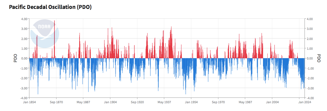
Seems like a PDO flip would be good for us?
.Yes. On GaWx's map above(assuming those are examples of both...the positive phase is on the left), the positive phase on the left would favor less trough over the West. It is technically a Pacific Decadal Oscillation. Though it is often connectedt to ENSO state - not always. Because it is a decadal oscillation it can take 10+ years to flip, and it is long over due. Though, I make not claim to being an expert on this topic.
Her is NASA JPL's PDO page....
Here is NCEI's page....(I like this one better...you will notice some differences between the two pages)
https://www.ncei.noaa.gov/access/monitoring/pdo/
I can see why one person on X(reference Holston's earlier post) might say 2027 as that assumes the current cycle began during 2017 which also coincides w/ recent negative La Nina's. If one looks at the second NCEI site, one will notice lots of good winters correspond to +PDO cycles. We are actually due for it to come up for some air. It will sometimes turn briefly positive even during a negative cycle just according to NCEI's data. It doesn't have to be positive for long....even just briefly will do it. Maybe that is what JB is banking on? If so, there is some merit to that. We are in a pretty long stretch, and it should have gone positive this winter, but didn't. Pretty rare for it to stay negative for much longer than it has recently. This is anomalous negative activity.
-
6
-
-
Just reading D'Aleo over at WxBell who I respect a lot....he has a graph of one area of the Pac where the El Nino just collapsed during mid January (100-180?). I have not looked to see where that is, but I do wonder if the collapse of the El Nino has had a significant effect on the second half of winter. We kind of got the worst of both worlds - first half Nino(typically warm) and second half Nada(typically warm!). We managed about ten days of weak El Nino...and many scored.
Also, JB thinks the PDO is set to flip positive next winter. I see no evidence of that but haven't looked at recent metrics for it. Anyone have a forecast for it?
-
4
-
-
Possible changes afoot. By using the general 4-6 week pattern rule, the current pattern should end during week 1 or 2 of March, and a new pattern should begin. The last couple of weeks of March do not look warm...could be a mirage, but let's see. I am completely ditching the MJO at this point. During spring it often doesn't have as much influence, and it is a very garbled signal.
-
3
-
-
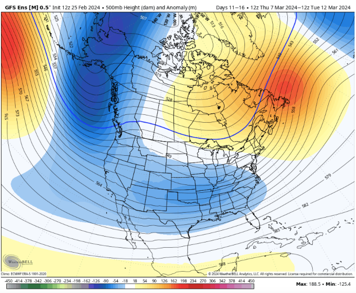
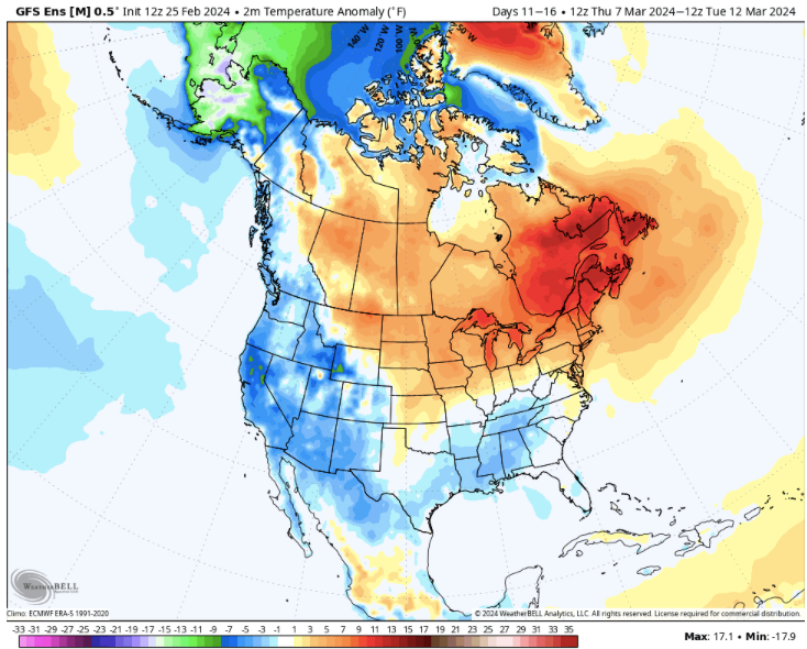
D10-15 GEFS looks interesting...
-
3
-
-
Both the 18z GFS and 12z Euro control have a winter storm in the d8-10 range. Just something to watch.
-
3
-
-
Definitely got a heavy dose of graupel. To quote one of mine, "It looks like it is raining ice cream salt." High winds and salt coming down....
I could make a case that it is hail, but it is certainly frozen.
-
3
-
-
Congratulations to all scoring some frozen precip. We have had some sloppy rain in Kingsport, but I am pretending it is frozen.
-
1
-
-
This is the second straight weekend of snow showers and flurries for portions of TRI. And that is remarkable given how warm the weekdays have been!
-
5
-
-
Winter Wx Advisories are now posted for the Apps. Sam's Gap appears to be a mess. Newfound Gap is closed.
URGENT - WINTER WEATHER MESSAGE
National Weather Service Morristown TN
353 AM EST Sat Feb 24 2024

TNZ018-043-045-047-242100-
/O.EXB.KMRX.WW.Y.0006.240224T1500Z-240225T0600Z/
Johnson-Southeast Greene-Unicoi-Southeast Carter-
Including the cities of Doeville, Mountain City, Neva,
Shady Valley, Trade, Laurel Bloomery, Cedar Creek, Erwin, Unicoi,
Limestone Cove, and Hampton
353 AM EST Sat Feb 24 2024

...WINTER WEATHER ADVISORY IN EFFECT FROM 10 AM THIS MORNING TO
1 AM EST SUNDAY...

* WHAT...Snow expected. Total snow accumulations of 1 to 2 inches
  above 2500 feet, and 2 to 3 inches above 4000 feet. Winds
  gusting as high as 35 mph.

* WHERE...Johnson, Southeast Greene, Unicoi and Southeast Carter
  Counties.

* WHEN...From 10 AM this morning to 1 AM EST Sunday.

* IMPACTS...Plan on slippery road conditions.

PRECAUTIONARY/PREPAREDNESS ACTIONS...

Slow down and use caution while traveling.
-
4
-
-
On 2/22/2024 at 9:55 PM, *Flash* said:
If the Euro Weeklies are going warm, I'm going to expect a cold snap. I believe in Murphy's capacity to thwart and troll spring breaks in our region.
Word.
Yeah, for sure! Weeklies are still cold, but have trended warmer....so, we will watch the trend. We are in a "base warm" pattern currently, and I don't see any evidence in the next three weeks for that to change. But yeah, when Spring Break arrives I expect frost all the way to Tampa!
Powell is right. Warm February's often result in an extended cold shot during spring. And there are pretty good reasons for that. It usually means that the TPV has been pretty stable at higher latitudes. Usually(not always), it is going to get disrupted by changing wavelengths during spring and head towards middle latitudes. Sometimes we are fortunate and it just sits tight and doesn't move.
-
5
-
February 2024 mid/ long range
in Tennessee Valley
Posted
Monster Post
A little bit of this, and a little bit of that type of post...Be sure to check the links as they have great information. The Rutgers Snow Lab is pretty phenomenal.
Part I (The past):
Again, I think the GOA low pressure (on steroids) just prior to Christmas cooked our goose. It created a massive Chinook. When the pattern switched to a favorable eastern trough just days after Christmas, there was zero cold air to dump into it. If that GOA doesn't develop, we make out like gangbusters. It wasn't until the back half of the pattern when the NAO matured that we got enough cross polar flow to reach into the SE and connect w/ the active STJ. You can see the storm track clearly.
Here is the animated storm map for the season (goes storm-by-storm):
https://www.nohrsc.noaa.gov/nsa/js_animate.html?nsteps=151&year=2024&month=2&day=29&type=ruc_snow_precip®ion=National&ts=24&large=1
With the accompanying link, you can see the cold press southwestward during late December and early January. At that point it is just the luck of the draw. With the lack of strong source regions, the cold never really made it into the eastern coastal Plain. I think part of that was an active STJ, and part of it was the cold parked itself in Eurasia. That happens during some winters.
Part II (Current):
Additionally, I think we have ENSO natural conditions currently (maybe even a bit earlier than predicted):
https://www.cpc.ncep.noaa.gov/products/analysis_monitoring/enso_advisory/ensodisc.pdf
I think we kind of are in a quick transition to nada and then Nina. But beware, the potential for a cool, spring(especially mid-later March) due to a Nino rebound/hangover....lurks. I borrowed a graphic from The Weather Channel for ENSO neutral aka La Nada:
Part III (Big Picture):
Here is a plot for North American/Greenland combined snow cover trends. This forum would have STRUGGLED during the 90s winters after 95-96. Many of those years were El Nino, some supers. They were brutal in terms of snow - and I mean brutal. During one winter, we didn't even quit mowing. You can see that in regards to this graph. Take a look at January 2024 and decadal trend - up. Interestingly, December has really increased while Feb/March (over the years) have decreased. That fits what I am seeing IMBY - more snow in early December than I remember, but less snow at the end of winter. Also, I don't remember much December snow at all as a kid(70s and bell bottoms)...and the linked NCEP confirms less snow during 70s Decembers for NA. Winters seem to be starting a bit earlier in terms of now in the eastern valley, but close up shop during spring earlier. Fun site...link is below the graphic.
https://www.ncei.noaa.gov/access/monitoring/snow-and-ice-extent/snow-cover/namgnld/1
Again, if you think it is bad now...go look at the 90s.....
https://climate.rutgers.edu/snowcover/chart_anom.php?ui_set=0&ui_region=nhland&ui_month=1
Part IV (Future):
The strength of the La Nina(the Nina watch has been issued) will be key to next winter. If the La Nina is weak, I am going to feel pretty good for most areas of the state. If it is moderate - just middle and west. If it is strong - torch. I look a little less at where it is centered and look more at its strength.
Right now to my eyes, it looks weak. Weak La Nina patterns have been very good to western and middle portions(even to Knoxville) recently...some years weak La Nina patterns can push well east of that. And those years have been great. Summer impacts would likely mean an increasing dry and hot pattern for July and August(likely lasting into early-mid fall) w/ a sharp switch to a colder pattern for November.