

87storms
-
Posts
8,023 -
Joined
-
Last visited
Content Type
Profiles
Blogs
Forums
American Weather
Media Demo
Store
Gallery
Posts posted by 87storms
-
-
The 270 split precip magnet is at it again.
-
 1
1
-
-
These cells have been doing the ol' Catoctin skip. Not much rain imby the last couple days...I might be a bit too close to the mini rain shadow. Next few days are looking summer'y.
-
11 minutes ago, Mrs.J said:
Have a nice cell that started just to my immediate SW. Had some lightning with it at first now just heavy rains right over me.
ETA getting some nice fireworks again.
Hearing the thunder from that, but so far it's sliding to my SE.
-
Today has better storm vibes, at least hit/miss. Sun, calm wind (I'll confirm during lunch), and humid. We have a decent track record with those variables.
Jk, unless I wasn’t.-
 1
1
-
-
Today has better storm vibes, at least hit/miss. Sun, calm wind (I'll confirm during lunch), and humid. We have a decent track record with those variables.
-
1
-
-
I want what's outside for 8 months out of the year with 1 month of fall, 2 months of winter, and 1 month of spring.
-
 1
1
-
-
Unexpected thunder.
-
Another batch moving through the swamps of Frederick. Might reach 0.5" for the day in my neck of the woods.
-
Was hoping the warm front would push a little further north, but seems like it's hit a wall. Not expecting much up here with the current temps and cloud cover except periods of showers.
-
The current drought monitor illustrates one of the greatest comebacks in mid-Atlantic history.
-
1
-
1
-
-
1 hour ago, MillvilleWx said:
84/67 for the temps today at mi casa. Already down to 75 there thanks to a slight breeze off the water. Currently 83 at work
It definitely has that classic, mid-Atlantic swampy feel outside, I'm assuming in part due to how saturated the ground is. Nothing like the last few years.
-
1
-
-
17 minutes ago, George BM said:
Lol. I'm out of the summer touch at the moment. 84/62 is kicking my butt for some reason... probably due to the extended cool period. I'm screwed aren't I.

It takes a little adjustment, but this weather is so much more versatile.
-
1
-
-
Now this is the weather I need.
-
1
-
 1
1
-
-
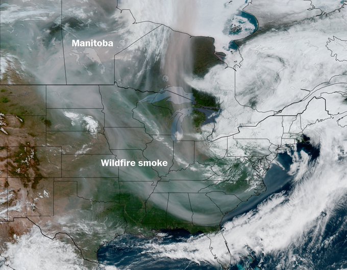
48 minutes ago, frd said:
This is from yesterday, but today it is still similiar. Goes from Manitoba to almost Northern FLA.
I don't know if it's my allergies acting up or phantosmia playing tricks on me, but a couple times today I could smell a faint "smoky" scent, similar (but to a lesser extent) to what we experienced 2 years ago.
-
I’m a summer baby, bring on the heat!
Samesies lol. And I get “crabbier” about colder weather as I get older. But I will say…the temps are a bit nicer than I expected today…was expecting chilly (thank you, June). -
35 minutes ago, mappy said:
Can’t wait
This
-
1
-
-
38 minutes ago, frd said:
This loop sure looks like smoke in the upper levels over a wide area of the East.
https://www.star.nesdis.noaa.gov/GOES/conus_band.php?sat=G19&band=GEOCOLOR&length=24
Yea, the reflectivity looked smoke'ish. This has been an off and on thing the last few years and a reason why I don't like those upper level lows spinning over the northeast this time of year.
-
Was just about to say that. Looks like smoke aloft this morning.
It looked like it on satellite, so I checked out LWX and they mentioned it as a possibility. Not sure if the current sat loop is showing smoke or high clouds or a mix of both, but HRRR vertically integrate smoke loop shows a swath of it to the west. -
Yea, this weather ain’t it. And it appears we’re going to be contending with Canadian wildfire smoke…at least at the upper levels.
-
It went from nice (nearly epic alert level) to cloudy/rainy quickly here in Baker Park and windy. Is it summer yet?
-
Looks like this will ultimately be a bit of a bust up here. Had one round just move through and one last batch moving through now before the lull (not really expecting much from the wraparound stuff). Looking forward to the summer-like weather next week.
-
Just drove thru an absolute torrential downpour.
-
5 hours ago, high risk said:
The more northern track of the surface low likely reduces the flash flood threat for most of us, but it definitely increases the severe threat. Surface winds may end up too light, but if they’re not, some of the morning guidance does show enough turning in the low levels to generate favorable hodographs. The 12z HREF reflects this with a notable increase in the probabilities for good UH values into the DC/Baltimore region, relative to earlier guidance, and I would not be surprised if the 1630 outlook brings the 5% TOR further north.
Our region is an upper level low repellant, especially in the winter. I'm just glad we'll get at least scraped by this system.
-
That guy in VA was wrong...the last 2 days have been outstanding basketball weather.
June Discobs 2025
in Mid Atlantic
Posted
Meanwhile, looks like the "haze" today is from more wildfire smoke. It's just getting ridiculous at this point.