8611Blizz
-
Posts
1,592 -
Joined
-
Last visited
Content Type
Profiles
Blogs
Forums
American Weather
Media Demo
Store
Gallery
Everything posted by 8611Blizz
-
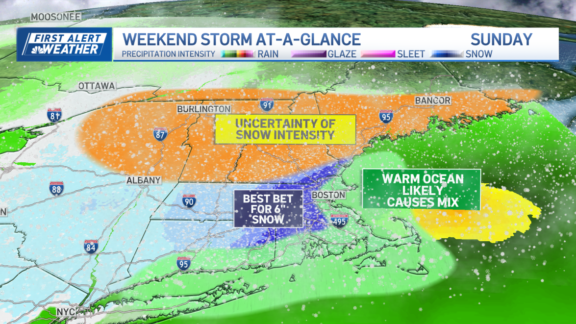
 Looks pretty sleety here for most of Sunday
 -
I live in west Somerville but work mostly out in East Somerville and East Cambridge. I have plowed my driveway with 2 or 3" and driven 3 miles east to be met with a dusting or sometimes rain. I don't think it will be that bad but I do expect a gradient.
-
That wind is a bitch to forecast. Having just watched the TV Mets they are also putting up caveats about it. Bz just posted a map about the area of greatest uncertainty and it was boston down 24 to 495.
-
Yeah wcvb is too high imo. NBC is 2-4 1-3. I think that's more realistic.
-
Local TV Mets have made some adjustments near the coast but they may need to do that up until tomorrow night.
-
Expecting extreme gradient. Here in west Somerville about 4 and probably 6 in north Arlington but east Somerville maybe 2. At least it's something.
-
FWIW Bouchard has a graph showing in Boston metro being above freezing until late Sunday morning and not accumulating much until after Noon. Of course he also has Boston at 3" for a total.
-
As a coastal dweller about 5 miles from Logan that redevelopment is key here. Difference between 2 and 6 probably.
-
Kind of all over the pace with the heaviest stuff. There is even more variation on other stations but still to early to get excited or disappointed.

-
Yeah nws is not that enthused for the coast in particular. They don't seem to have much faith in the heavy solutions.
-
Seems reasonable for the time frame.
-
Tell me about it. Maybe it will school the Americans like not so long ago.
-
Me too but the expectations its setting are about as perfect as I can remember. The ball is in the GFS court now. Good old fashion model war...
-
Comes in like a wall and drops a footer in Boston. Thing is though, that track is PERFECT. Like true perfection. What could go wrong?
-
Local Mets are all over the place. Some say a fast mover, others a long duration, still others say rain/sleet is an issue. Fisher mentioned shearing and strung out as an issue. Still early at least.
-
Yeah he used that phrase too
-
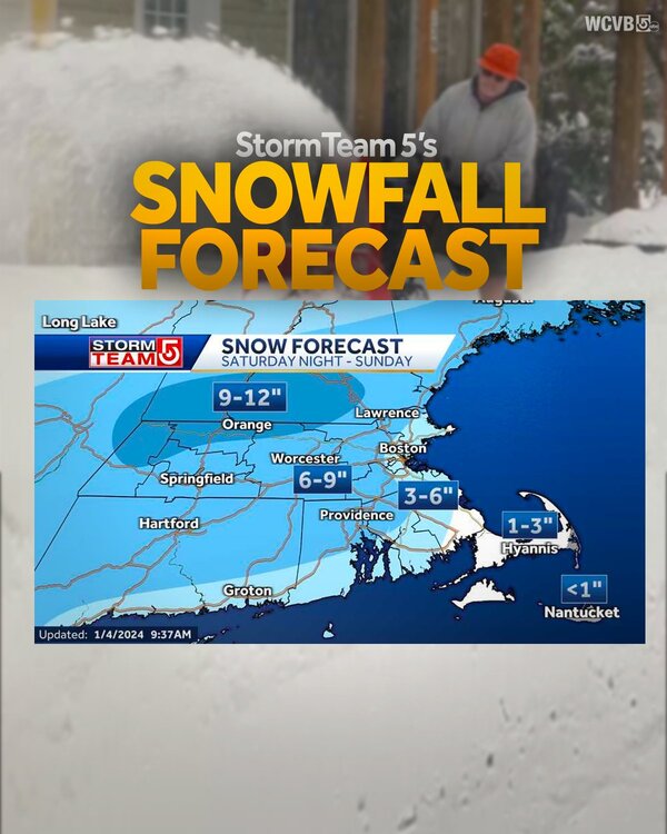
Yeah noyes already mentioned rates would be key for Boston and South coast. Also mentioned to not think about 6+ at this point around here anyway..
-
If it holds it looks like the 7th will mostly happen during the day. It's been awhile for decent accumulating snow here on the coast to happen in daylight hours.
-
Sox trade sale for Grissom.
-
This thread is going to the same place threads went to last season... https://tenor.com/z1Jl.gif
-
Complete BS https://youtube.com/clip/UgkxW6RRoachQbosxov8jvI1ievfWOpcsQPg?si=-FE5kzxPl0tW7ivi
-
Repression.
-
Don't sell clippers short. They have been the backbone of winters around here. At least they used to..
-
https://tenor.com/bfSut.gif I was hoping to not need this before February.
-
hopefully we don't too many of these this year