mahantango#1
-
Posts
5,043 -
Joined
-
Last visited
Content Type
Profiles
Blogs
Forums
American Weather
Media Demo
Store
Gallery
Everything posted by mahantango#1
-
Yes it does, we (I) have seen it so many times over the years happen. But still we (I )still refuse to believe it will happen again. We all seen it happen earlier this winter and recently too.
-
Loving a good thunderstorm soon. It's that time of the year.
-
15 this morning.
-
Respect is earned, Thats why it's so hard to unseat the reigning champion.
-
In the meantime while were waiting for the return to winter. I might as well get my mower ready for the competition.
-
19 was the low.
-
Going to be another cold night. Already down to 28.
-
Inquiring minds wanna know what did happen at The Hotel Hershey Friday night...but than again maybe we don't.
-
Oh, oh, someones gonna be without a blade.
-
Sounds like this event is in need of a few sponsors.
-
From the sounds of this there might be some fierce competition this season for that cup! Never to early to get prepared for the season. This seasons race to the cup might be won in the pits.
-
So the Most Mows Championship Series could have an early start this year? Who is the preseason favorite to win that coveted cup?
-
Winters are not what they used to be when I was growing up. Well there's always next winter to look forward to. I guess the march on to spring will commence shortly.
-
Even though we have 10 days or so left in meteorological winter. Meteorological spring will be here in 10 days. I haven't seen any outlooks for spring so far.
-
Sounds like basically the fork has been inserted into winter. 13 here this morning.
-
-
Yes I think I'm gonna go lower too. I'm gonna go for 9.
-
I'm going for 15 here. Hope im wrong want it warmer.
-
10 this morning here Too, too cold. Now get ready for wind today. Hazardous Weather Outlook National Weather Service State College PA 356 AM EST Sun Feb 18 2024 PAZ004>006-010>012-017>019-024>028-033>037-041-042-045-046-049>053- 056>059-063>066-190900- Warren-McKean-Potter-Elk-Cameron-Northern Clinton-Clearfield- Northern Centre-Southern Centre-Cambria-Blair-Huntingdon-Mifflin- Juniata-Somerset-Bedford-Fulton-Franklin-Tioga-Northern Lycoming- Sullivan-Southern Clinton-Southern Lycoming-Union-Snyder-Montour- Northumberland-Columbia-Perry-Dauphin-Schuylkill-Lebanon-Cumberland- Adams-York-Lancaster- 356 AM EST Sun Feb 18 2024 This Hazardous Weather Outlook is for central Pennsylvania. .DAY ONE...Today and tonight. West-southwest winds will gust into the 35 to 40 mph range late this morning through this afternoon. .DAYS TWO THROUGH SEVEN...Monday through Saturday. The probability for widespread hazardous weather is low.
-
-
Close to 5 inches here and still snowing with wind starting. temp 29
-
Snow has commenced here.
-
He might have to change that last call again with the new Winter Storm Warning that was just issued.
-
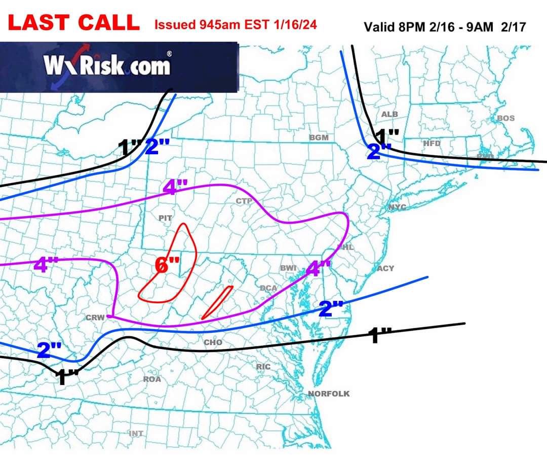
From our great friend DT: last call
-
Yes we got snow up here last night. from Facebook this morning: Tina Wilbert sSrepndtoo17t95il83i625utg5ut1mfm4h037t63516t4gg2a8al15g5839 · Use caution in Berrysburg and Gratz. Lots of snow drifting and black ice All reactions: 2323 1 comment 20 shares Like Comment Share Mike Swanger And just outside eville to Berrysburg on 225 drifting snow! 2 2h Like Reply Share