Met1985
-
Posts
16,018 -
Joined
-
Last visited
Content Type
Profiles
Blogs
Forums
American Weather
Media Demo
Store
Gallery
Everything posted by Met1985
-
Things are getting narly know in a hurry. Big gusts coming through now. There are all kinds of downed power lines through Haywood.
-
There's a roar with this wind driven rain now... Very eerie.
-
It's just dumping out there currently. This is not a good situation we are in. A lot of rivers are out of there banks already.
-
Damn alarm again! I was ready this time.
-
The weather here is really deteriorating out there. Torrential rains and high winds.
-
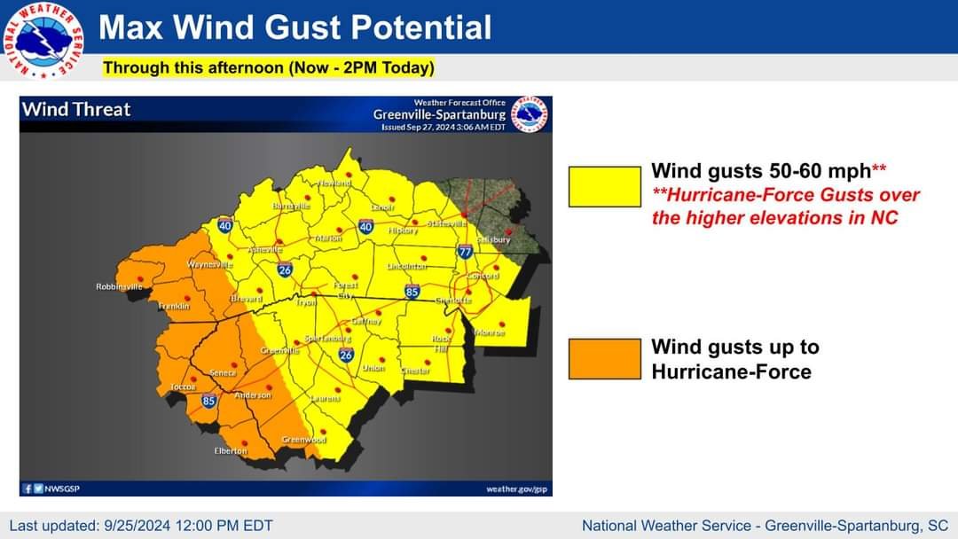
Wind gusts starting to ramp up across the southern portion of the area. With Helene currently situated over south-central Georgia, the wind field associated with Helene will allow for strong wind gusts to overspread all of the western Carolinas and northeast Georgia over the next few hours as the system lifts north, closer to the area. The combination of strong wind gusts and very saturated soils from previous and ongoing heavy rainfall, widespread downed trees and numerous power outages are expected through this morning. Sent from my SM-G998U using Tapatalk
-
Yeah winds have been roaring hear. Had a big tree fall behind the house then a flash flooding emergency message came across blaring.
-
Yeah especially when the wind is cranking up already. Lol glad I'm not the only one that did it too! I was like WTF!
-
Just heard a huge tree fall back behind my place. Luckily it's just a mountain but very eerie to hear.
-
Another 1.25 inches in the bucket. 7.57 total now.
-
The siren in Clyde has been sounded. The river is out on Thickety Road at Thompson Cove & on Hyder Mtn. Currently Hyder Mtn Road is closed between Chambers Mtn & Richland Creek Rd. In the need of immediate evacuation please call 911. If you need sheltering please report to 410 Charles St in Clyde. This is per the fire department.
-
Yeah NOT looking forward to this coming through the mountains.
-
This current wave that just came through is straight tropical in nature. Gusty winds and torrential downpours with the power flickering.
-
Freaking crazy.
-
No shit. We've got people who already have over 15 inches and counting. They say the French Broad river in Buncombe county is supposed to crest at 30 feet tomorrow. That's 10 feet above the current record... And let's not talk about the winds coming through...
-
Another 1.25 this evening.
-
Kind of. I think it'll fill back in though pretty quick.
-
Yeah nonstop too. Just relentless.
-
Well you do basically live in a Rainforrest lol.
-
No kidding!
-
Yeah this is some crazy stuff! It's absolutely pounding the rain currently now.
-
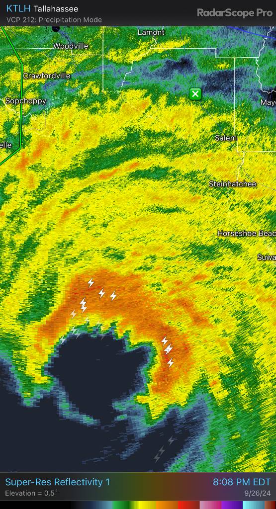
The NNE side of the eyewall is a beast! Sent from my SM-G998U using Tapatalk

-
Yeah this is definitely a historical event. Kind of wild by about 4 am this thing is going to be on our doorstep.
-
This. Ride this mofo out up there.