

NC_hailstorm
-
Posts
2,525 -
Joined
-
Last visited
Content Type
Profiles
Blogs
Forums
American Weather
Media Demo
Store
Gallery
Posts posted by NC_hailstorm
-
-
41.2 DP 26
Sunday-Snow. High near 32. North northeast wind 16 to 18 mph, with gusts as high as 28 mph. Chance of precipitation is 100%. New snow accumulation of 7 to 11 inches possible
-
The FV3 has been running pretty well lately by the verification scores so we'll see.
-
 1
1
-
-
Heights are a little lower on the Ukie with the 570dm deeper into the upstate and south of CLT this run compared to 42.
It's only 20-25 miles maybe but every mile counts now.
-
1
-
-
I might save this one.Day 8 Euro.
-
2
-
 1
1
-
 1
1
-
-
Wedge still holding here 48.4 but the forecast high s 70.1.52'' in the bucket.
Don't think I ever seen this wording in a 6 day forecast though.
Rain and snow likely. The snow could be heavy at times. Cloudy, with a high near 39. Chance of precipitation is 60%.
-
1
-
-
Ukie has a 1037 high over the Great Lakes at 144 with a low in far South Texas.
Heights might be a tad lower in NC compared to 12z.
-
3
-
-
Lower heights on the 0z Euro,at 132 it has the 562dm line coming through S. central NC.
Ukie looks a tick better at 132 with that more through the upstate,GFS flared off and went warmer but i don't watch that beyond day 5 anyways.
-
2
-
-
May or may not mean nothing but the Ukiie at day 6 is very close to what the GFS has in regards to heights.
At 144 the Euro is pushing the 564dm line into N.North Carolina while the other two aren't nothing close to that look.
-
I probably shouldn't say this but that looks like December 18,2009.
Strong shortwave into southern California/N.Mexico heading east with a fairly deep trough in the southeast.There was also a sharp cutoff along I-85 in that.
-
1
-
-
33.4 some very light IP came through a while ago.
Winter has officially begun.
-
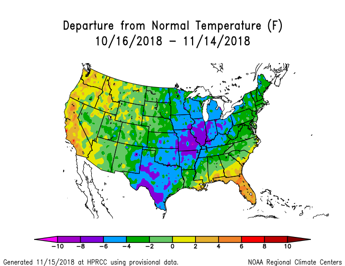
Overcast,breezy and 37.2
Bout 20 degrees off from normal
-
Winter Weather Advisory up for the NC Mountains,Foothills,and NW Piedmont of NC tonight.
-
Pattern can produce if the Solar/QBO signal is favorable which it is.It can produce in early December just like it did in late March.
-
1
-
-
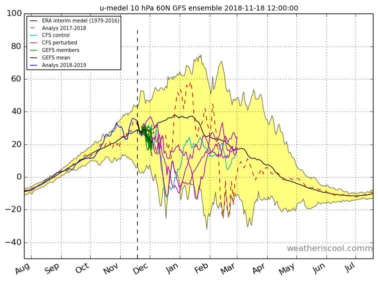
CFS has been sorta bad lately but it is showing a crash in zonal winds around Mid/late December at 10Hpa(technical SSW).This will be a bottom-up event if it happens,warming from 100mb to 50mb going up to 10mb reversing it for a while.Usually leads to more blocking.
GEFS gets it down to 20 m/s at the end of it's run also at the beginning of December.
-
2
-
-
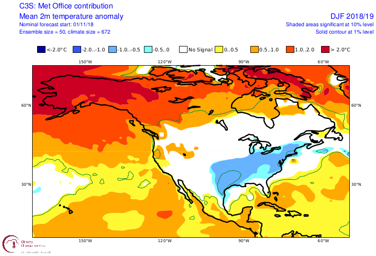
2M temps on the Ukie,look pretty cold today.I haven't found forecasts for separate months they forecast 3 months together as far as I can tell.
-
1
-
-
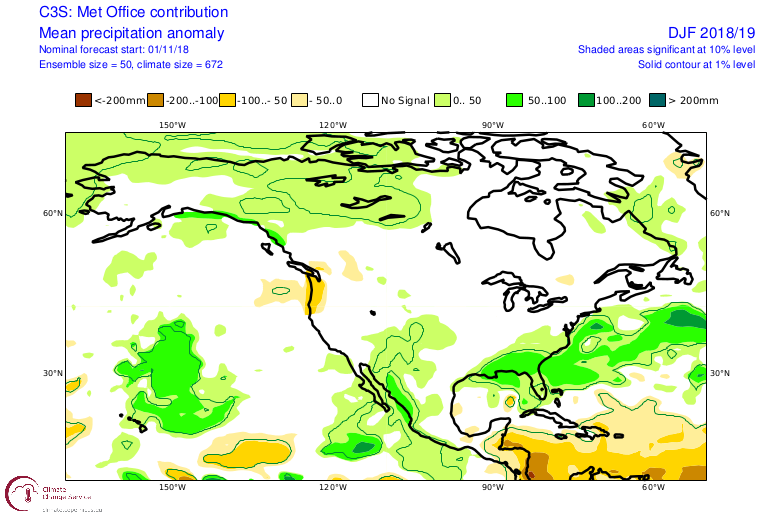
Precip
-
2
-
-
Couple more from the Ukie.Euro is pretty close to these but I'm not sure If I can put their maps on here.
Here's Heights.
-
2
-
-
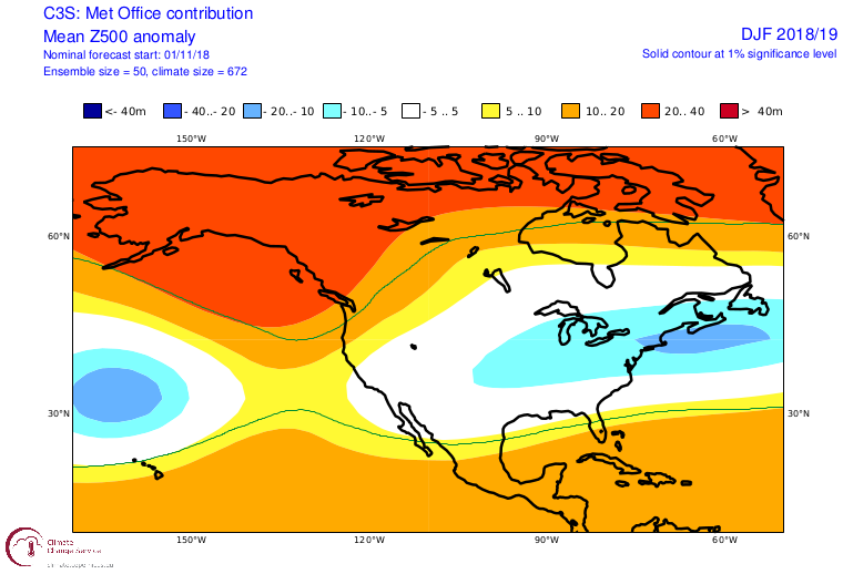
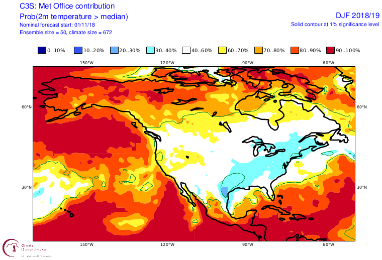
Ukie going cold for DJF 2018-19 Winter
-
Lower heights/trough pushing SE over the last 30 days.
-
The Solar/QBO signal is pretty good right now,solar wind running 390.6 over the last 30 days and the QBO coming in at -2.79.Solar wind is lower than last year at this time,2009-10 levels ran around 350 but I believe anything lower than 400 or close to that is solar minimum in my opinion.QBO will switch westerly at 30mb but if that lingers around 50mb to 100mb that could promote blocking.
Sun has been flaring up the last 4 or 5 days and this will need to be watched,but the forecast is for quieter conditions starting this week till the first of December.EEP levels also responding lately dropping close to 09-10 levels but this last flare up made them jump.Sun really flared up in late August,all of September and half of October with solar wind levels hitting 750 at peak.
Solar minimum drives the jet stream further south,especially across N America,I wouldn't be surprised if it's the main driver in the weather soon,1986-87 is also a decent match that was solar minimum with negative QBO and El Nino conditions.
Carry on.
-
1
-
 1
1
-
-
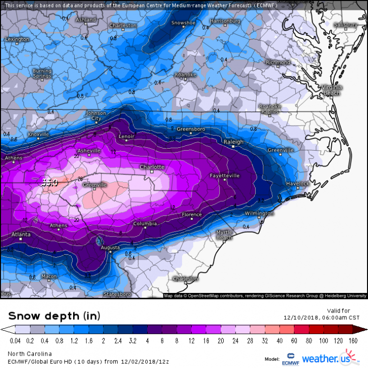
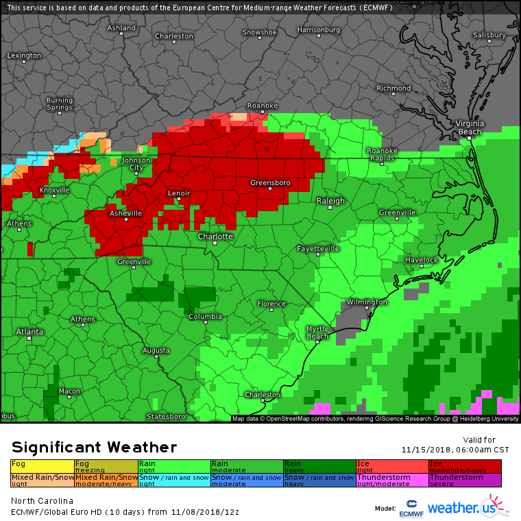
Well that escalated quickly,day 7 Euro.First ice/snow map of the winter.

-
3
-
-
43.5 with 2.14'' in the bucket so far,little more coming.
-
Look at that FV3 close the gap and run neck and neck with the big dogs.Ukie actually slipped past the Euro and is king for a day.

-
Solar wind today ranged from 271-290,that's the lowest levels I've seen in 9 years and matches close to 2009-10.
That is definitely solar minimum conditions if they persist,carry on.
-
3
-


December 8-10, 2018 Winter Storm
in Southeastern States
Posted
Right now I'd say the Euro and the FV3 look pretty close with the cutoff line somewhere along highway 73 in the southern piedmont of NC.
Sleet will probably mix in everywhere time to time with warm pockets coming through but more south of there.
Carry on.