

NC_hailstorm
-
Posts
2,593 -
Joined
-
Last visited
Content Type
Profiles
Blogs
Forums
American Weather
Media Demo
Store
Gallery
Posts posted by NC_hailstorm
-
-
Winding down here,I'll go with 1'5'' total.
-
Moderate snow here,sticking to roads.
25.7
-
 1
1
-
-
Another moderate/heavy burst coming through,lot more than what I was expecting lol.
29.3
-
Nice burst of snow here now,coming down moderately.
31.6
-
Flurries/light snow here .
32.5
-
Euro phases at 84-90 and a big storm,still cookin.
UKMET with a partial/late phase.
-
18z Euro is Cookin lol.
-
1
-
 1
1
-
-
Euro Ensembles are Cookin lol.
-
4
-
 1
1
-
-
Hmm that -5 AO might be starting to flex.
-
4
-
-
12z Euro is Cookin lol
-
1
-
-
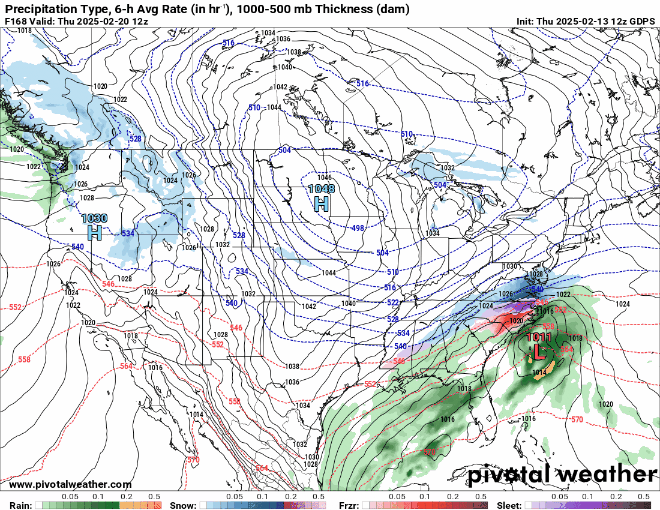
Actually the AI is close to a bomb the 12z ICON showed yesterday.
525 strong heights in Michigan,southern shortwave close to the Mississippi,northern stream dropping in from the midwest.Couple ticks.
Just my opinion.
-
1
-
-
Need a little better press/push from the north,the 504 dm PV needs to move more over the Great Lakes and not lag back.
Ice/sleet setup at the moment but could change with a few adjustments.Just my opinion.
-
2
-
-
UK with a phase around 150-156,another bomb up the coast. Cookin lol.
-
1
-
-
CMC phases at 150-156,big storm up the coast.
-
 1
1
-
-
2 hours ago, WXNewton said:
The ICON and Canadian are really not that far off from each other, the ICON just seems to phase earlier for a bigger storm. Also, looks like the ICON keys more on the trailing energy than the Canadian. Seeing the Canadian further south and east at this stage in the game is probably a good thing, we know how that will go as it gets closer.
The ICON gets the phase at 162 close to the Mississippi River which is perfect for here.Anything too far west or east of there probably won't work.
The 500 mb map on the ICON at 162 is what I'm looking for,cooking lol.
-
4
-
-
Looks like a phase at 168 on the Canadian,northern stream catches that southern shortwave.
Cooking lol.
-
14 minutes ago, olafminesaw said:
Whale whale whale

Now we're cooking lol.
-
5
-
 1
1
-
-
UK is about to unload at day 7,trailing shortwave behind that and that probably blows up.
-
1
-
-
Is that 30"" just south of Raleigh? lol gotta love it.
-
Looks like some light snow gets in here 171-180 but the GFS goes for that 2nd shortwave around 192-201 and blows it up.
-
Tanking AO,positive PNA, and a MJO coming into phase 8.
Even at day 7 right now all the models (EURO,GFS,UK,CAN) look very close to each other.I am mildly/moderately interested.
-
9
-
-
3 hours ago, BornAgain13 said:
The 12z AI was an absolute bomb... now obviously this is way out but just taking this 1 model verbatim, that's 18"+ in the pink lol
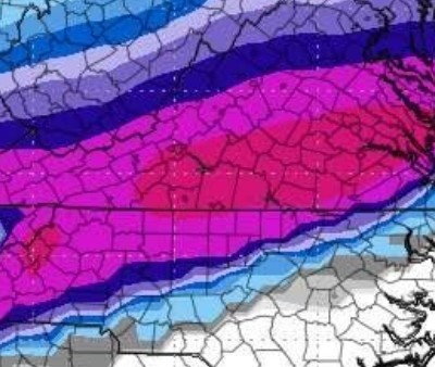
I think Big AL just unloaded again tonight at 18z,further south this time.
-
Light snow 21.9,my road literally got covered in 10 minutes just a fine powdery snow.
-
4
-
-
Flurries/light snow just started 23.2
-
1
-

February 19-20 Obs Thread
in Southeastern States
Posted
Oops 1.5''