UpStateCAD
-
Posts
308 -
Joined
-
Last visited
Content Type
Profiles
Blogs
Forums
American Weather
Media Demo
Store
Gallery
Everything posted by UpStateCAD
-

The “I bring the mojo” Jan 30-Feb 1 potential winter storm
UpStateCAD replied to lilj4425's topic in Southeastern States
Becoming clear greenville, Pickens, and oconee counties in SC upstate are in a storm minima area; and Charlotte is in the bullseye once again. -
The “I bring the mojo” Jan 30-Feb 1 potential winter storm
UpStateCAD replied to lilj4425's topic in Southeastern States
lol.......hope I am wrong. I certainly do not have the technical skill set to weigh in on this particular set up. But in all of my years here I have never cashed in on a ULL system in downtown Greenville, but i certainly have seen Spartanburg do very well. -
The “I bring the mojo” Jan 30-Feb 1 potential winter storm
UpStateCAD replied to lilj4425's topic in Southeastern States
Been through these ULL storms several times in the upstate; GSP west typically ends up in the losers bracket. The precip cut off (gradient) from west to east is typically severe. I have seen a 6 inch delta from GSP (eastern boarder of Greenville Co) to the Greenville/Pickens county line many times. Expecting the same sort of gradient this storm. Add in the leeside downslope dry spot that has been showing up on many of the model, I see a big bust for parts of the upstate. -
The “I bring the mojo” Jan 30-Feb 1 potential winter storm
UpStateCAD replied to lilj4425's topic in Southeastern States
quick question for those in the know. We are seeing some variations in predicted snowfall across the Carolinas, but I am seeing some decent differences in ratios as well. For example for my area (KGMU) the 12Z nam is showing ratios between 19:1 and 23:1 while the GFS is showing values between 12:1 and 18:1. Which model tends to do a better job address snow ratios? -
The “I bring the mojo” Jan 30-Feb 1 potential winter storm
UpStateCAD replied to lilj4425's topic in Southeastern States
Check please -
The “I bring the mojo” Jan 30-Feb 1 potential winter storm
UpStateCAD replied to lilj4425's topic in Southeastern States
apologies looks like this has already been addressed. -
The “I bring the mojo” Jan 30-Feb 1 potential winter storm
UpStateCAD replied to lilj4425's topic in Southeastern States
so given the nature of the air mass (cold) would the snow ratio being above 10:1 need to be increased for the values shown for the western carolinas or is that already baked into these AI runs? -
The “I bring the mojo” Jan 30-Feb 1 potential winter storm
UpStateCAD replied to lilj4425's topic in Southeastern States
where can one find the Weathernext runs? -
The “I bring the mojo” Jan 30-Feb 1 potential winter storm
UpStateCAD replied to lilj4425's topic in Southeastern States
i'd take it -
Southern Crippler - Get well soon Jimbo Storm Obs
UpStateCAD replied to BooneWX's topic in Southeastern States
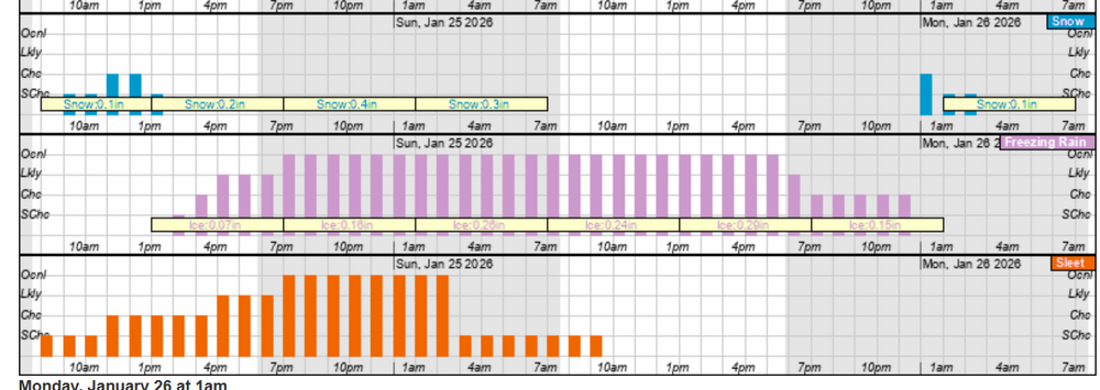
The was the craziest winter storm I have witnessed in my 35 years in the upstate. If you would have told me that we would have a winter storm roll through and drop 1 inch of precipitation with the temperatures between 25F and 30F for the duration, I could imagine multiple scenarios from 12 inches of snow to over a 1/2 inch of crippling ice to over 3 inches of sleet. What we did end up with was maybe an inch of sleet with a very minimal glaze of ice to end it. This set up is exactly what I have been waiting on for years. Definitely underperformed but I am thankful we did not see the ice they were calling for a la Nashville or Mississippi. -
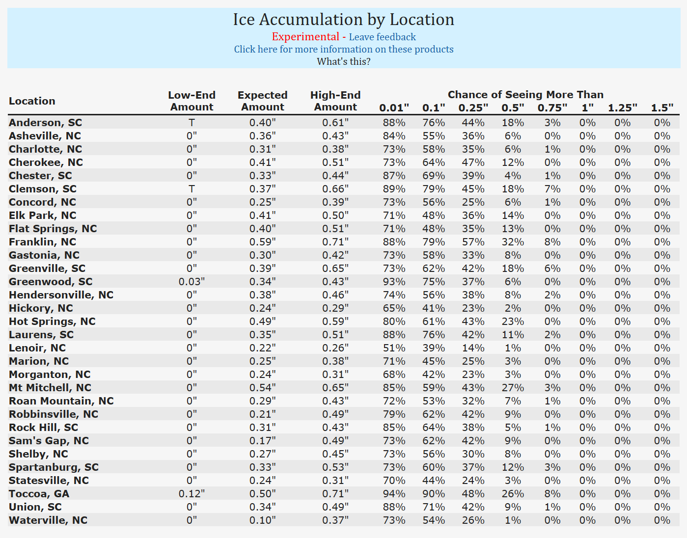
Then there is this for Greenville.....obviously the 2 do not align...
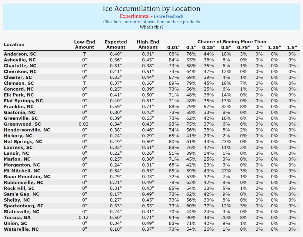
-
GSP experimental product. Not nearly as bullish as some of the models are depicting. Probabilistic Winter Precip Forecasts
-
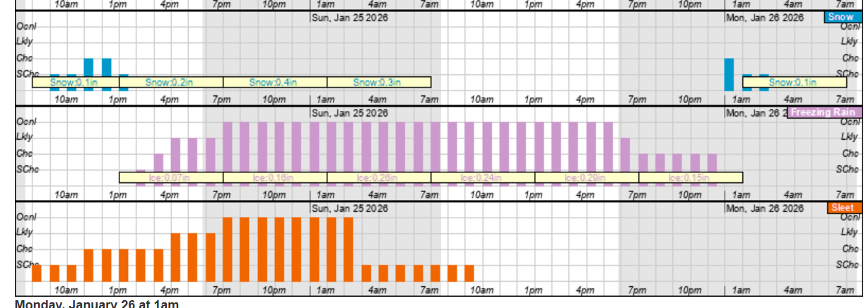
From what I have seen this morning both the Euro and the GFS do smash the upstate. An inch or 2 of snow, 2 or 3 inches of sleet (the combo of these 2 equates to approx just over an inch of liquid equivalent) with the balance being freezing rain (anywhere from 3/4 of an inch up to well over an inch).
-
good point
-
Not crazy about the trends BUT this is the NAM, and it is out of it's range to boot. Let's at least wait until it is in its range. Interested in seeing what the Euro and GFS show later today.
-
If I remember correctly from a decade ago when these sleet / ice storms occurred regularly, neither the gfs nor the euro handled the intricacies of the thermal layers well in these set ups. Is there a medium range model that does better with predicting snow vs sleet vs ice? Ignoring precip amounts? Was it the Canadian or the uk?
-
February 19-20 Major Winter Storm Threat
UpStateCAD replied to NorthHillsWx's topic in Southeastern States
Larry What area are you referring to? Raleigh? Any temperature maps or p-types to go with the JMA? -
Hey Hickory. You thinking the ice threat could get back to the upstate or ne ga or too early to tell?
-
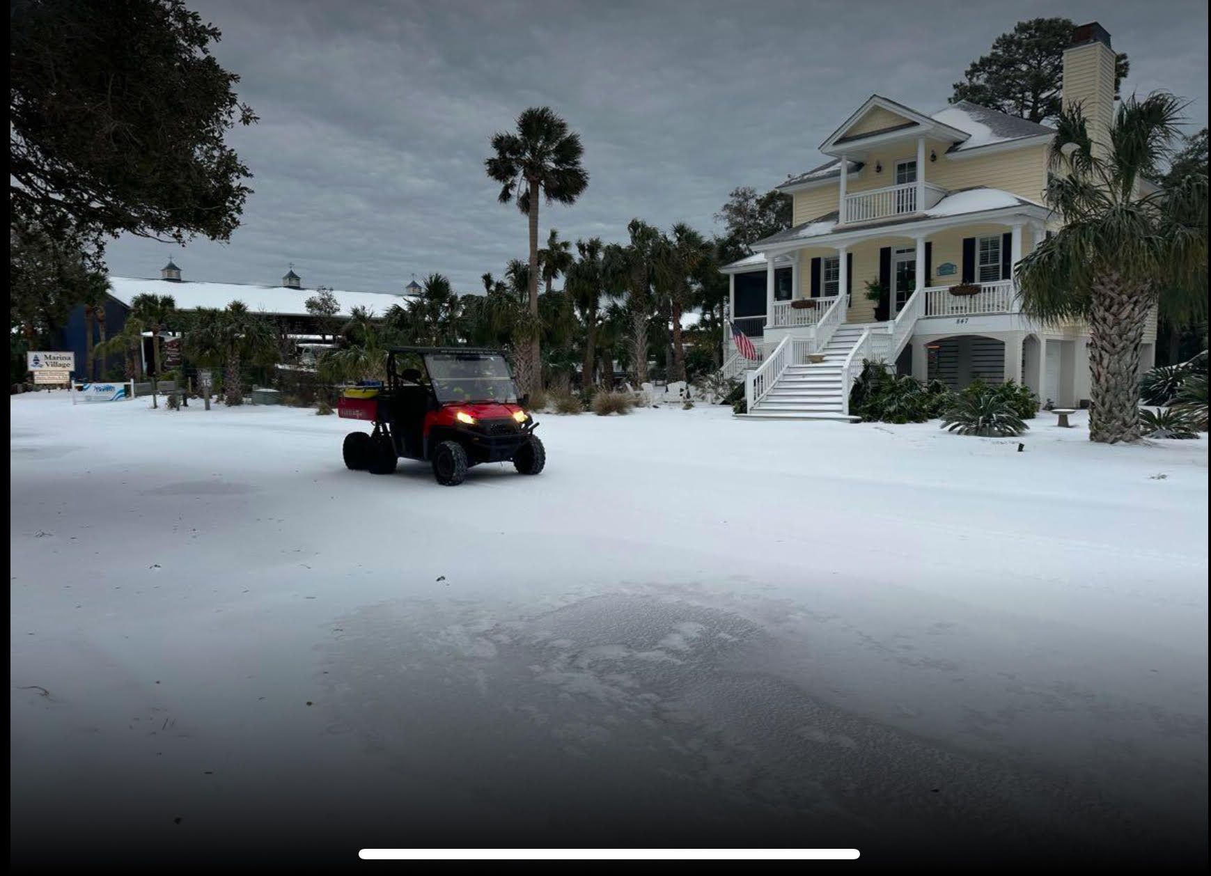
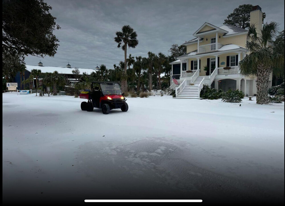
Fripp Island, SC
-
I would think this would be a very nice thump for the upstate into NC.
-
I think ice accumulations are going to end up higher than anticipated in the upstate. Have had light freezing rain for the last 2 to 3 hours. At about 0.1 in per hour. Temps are hovering around 29 F so perfect conditions for accumulation.
-
1/10-11 super awesome winter SE OBS thread
UpStateCAD replied to strongwxnc's topic in Southeastern States
Total bust at GSP. Official snow total so far at the GSP airport is 0.1 inch. Total storm equivalent precip so far is 0.11 inch. Most models were showing between 0.6 and 0.85 inches of precipitation. -
Nope. In Greenville we have barely had enough accumulation to cover hard surfaces. All snow has stopped and have light sleet and freezing rain. Huge bust here but I understand there are several areas nearby that over performed (i.e. Atlanta, Clemson, Abbeville, etc).
-
Take a look at GSP’s Forecast discussion. Sounds like they are not quite sure what to expect either.
-
what's the latest RGEM showing? Chris Justice likes that model for GSP area. HRRR sure has been on to some nice runs as well.