

Chicago WX
-
Posts
18,395 -
Joined
Content Type
Profiles
Blogs
Forums
American Weather
Media Demo
Store
Gallery
Posts posted by Chicago WX
-
-
Got home about 15 minutes ago. Took several measurements (lots of drifting) and came up with 4.2". Pretty much been an inch per hour since it started.
-
Just wow here right now
-
 4
4
-
-
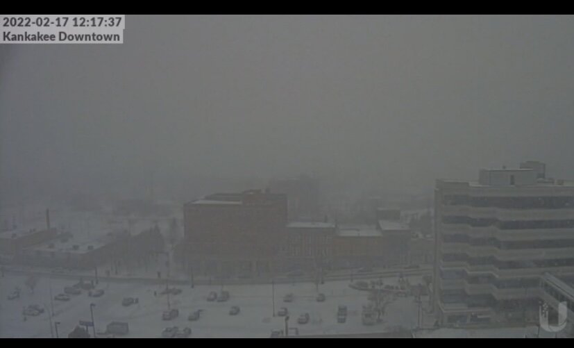
Getting close to a block visibility right now. Just pounding since it began. Too bad this storm is a quick mover…
-
2
-
-
29 minutes ago, WeatherMonger said:
Rain, sleet and snow today. Think they pulled mail carriers from their routes, going to have to change their motto...
.
Different breed down there.

We haven’t missed a day up here, including GHD III.

-
 1
1
-
-
Drifting is gonna be bad. Not a wet snow like LOT was thinking…
-
7 minutes ago, vortex said:
Jeb would be jealous. Haha
Downtown cam definitely verifies your observations.
That’s my route today.

-
Just pound town here. My visibility is 2 blocks at best right now. Walking south is ok, but walking north is hell with the driving snow.

-
8
-
-
17 minutes ago, vortex said:
Pretty much all snow here now at my house
Yeah, didn’t take long. Getting close to calling it rip city right now. Roads are a disaster already…
-
3
-
-
It has started here. But as sleet mixed with some flakes.


-
14 minutes ago, vortex said:
They were at 67 degrees yesterday afternoon.
Still reporting 1/4 mile visibility.They’re getting pounded. Read their AFD and they had the highest amounts in the south metro KC, but looks like the entire metro is getting slammed.
-
2
-
-
12z RGEM went wild, sort of.
Especially just to my southwest. Agree with Alek that’s there’s going a relatively narrow jack zone with the fgen banding. Where, who knows…
-
HRRR on the move back north, with each run, FWIW...
-
1
-
-
Rip city in Kansas City
METAR KMCI 171145Z AUTO 01013KT 1/4SM +SN VV005 M06/M07 A3007 RMK P0010 METAR KMCI 171140Z AUTO 01018KT 1/4SM +SN VV005 M06/M07 A3005 RMK P0009 METAR KMCI 171135Z AUTO 01018G25KT 1/4SM +SN VV005 M06/M07 A3004 RMK P0007 METAR KMCI 171130Z AUTO 01017G22KT 1/4SM +SN VV005 M06/M07 A3005 RMK P0006 METAR KMCI 171125Z AUTO 01016KT 1/4SM +SN VV005 M06/M07 A3004 RMK P0006 METAR KMCI 171120Z AUTO 01023KT 1/4SM +SN VV005 M06/M08 A3003 RMK P0005 METAR KMCI 171115Z AUTO 01019KT 1/4SM +SN VV005 M06/M08 A3003 RMK P0004 METAR KMCI 171110Z AUTO 02019G24KT 1/4SM +SN VV005 M06/M08 A3003 RMK P0002 METAR KMCI 171105Z AUTO 02020G26KT 1/4SM +SN VV007 M06/M08 A3003 RMK P0002 -
2
-
-
Think a WWA would suffice for here. Icing looks nil, and with the south bleeding continuing, 2-4” looks like a real solid call. Possible that’s too generous.
-
22 minutes ago, Hoosier said:
Higher
I actually feel fairly confident in pulling 6" here, especially with a little contribution from the lake. And I don't really care much about what the 12z Euro comes in with haha. How much over 6", I don't know.
Lol, good luck. But not basing it solely off the Euro. Taking all them into consideration, sans the GFS and NAM, leads me to my 4-6”. In some cases, that may be too high.
-
Global guidance led the way in this one. Selling the American models and going 4-6” final for MBY. Fits right inside LOT’s forecast for IKK.
-
6z Euro bumped a bit northwest. As did the RGEM. Goal posts narrowing…
-
1
-
-
1 minute ago, Hoosier said:
Got the link?

-
I remember when Hoosier found the developmental RUC (old name of the RAP for you young kids) that ran out to 36 hours or something. Him and thundersnow12 posted that sh*t constantly in every storm.
-
2
-
1
-
-
Have to sell the GFS and NAM kuchie numbers. They’re dumping 6 hour totals of 12-18” in spots. 2-3” per hour rates just aren’t going to happen IMO. Really think 8-12” amounts are a good range for LOT’s CWA, wherever that may be. Probably somewhere in the I-88/I-80 corridor.
6z Euro held serve. Battle continues…-
1
-
-
21 minutes ago, cyclone77 said:
Tim, Hoosier, and Josh have collectively stolen Geos' snow magnet.

Not feeling this one for here. Don't know why. But, if we got another dd storm, it would make for 4* such storms in a little over a year's time IMBY...Jan 30-31, 2021, Feb 14-16, 2021, and Feb 1-3, 2022. Quite a run.
*Feb 14-16, 2021 was just shy with 9.5", but we'll round up to make the above sound better.
-
2
-
-
1 minute ago, RCNYILWX said:
Definitely wasn't expecting solid dendrites that far north. Don't recall seeing any forecast soundings for your area and north that didn't have the omega above the DGZ.
Sent from my SM-G998U using Tapatalk
Yeah, I was kinda surprised. Earlier this morning it was just arctic dust. But then this little enhancement moving through later has been producing really nice dendrites. Pure fluff.
Back to the topic at hand, 12z UK and Canadian are not in agreement with the GFS. Still early of course.
-
1
-
-
Seems to be a sensitive set up versus the last storm, but the 12z GFS is acceptable.
On another note, been pounding parachutes at times here for the past hour. Where did this come from? Just gorgeous.

-
3
-
-
Steady light snow all morning. Prefect mood setter. Roads are still trash around here.
-
2
-
Feb 16-17th Winter Storm
in Lakes/Ohio Valley
Posted
My two snow lovers in the backyard.