

Chicago WX
-
Posts
18,285 -
Joined
Content Type
Profiles
Blogs
Forums
American Weather
Media Demo
Store
Gallery
Posts posted by Chicago WX
-
-
After a lull, dry slot #1 if you will, current band started as all sleet, and has now transitioned back to all snow. Coming down pretty good with decent flake size right now. In the end, all of this won't amount to much here...but it'll be all frozen, and fun to work (walk) on tomorrow.

-
7 minutes ago, vortex said:
Spitting snow here. NWS knocked us down to 1-2 with .10- .20 of crappy ice.
Good luck up north.Lol, sell the ice amount. We won’t get that much total precip. And 1-2” of snow looks about right. And then freezing drizzle. All in all, a totally forgettable “storm” for us. The beat goes on...
-
 1
1
-
-
16 minutes ago, Hoosier said:
Horrendous gap between 1981 and 1999, unfortunately coinciding with my childhood/early teen years. But that's what made the January 1999 storm so special.
Indeed. Only one that I can recall that we had in that "drought", in IKK, was the March 1991 storm (infamous central IL/IN ice storm) that dropped dd's here.
Note, MDW had six 10"+ storms in those 18 years, but obviously ORD was the official site during that time.
-
Chicago official 10"+ snowstorms (via LOT)
Jan 18-20, 1886: 14.0"
Feb 12-14, 1894: 11.0"
Dec 27, 1894: 10.1"
Feb 6-7, 1895: 13.4"
Nov 25-26, 1895: 12.0"
Feb 3-4, 1896: 12.5"
Feb 12-13, 1896: 12.0"
Mar 23-24, 1897: 10.0"
Feb 28, 1900: 11.3"
Feb 2-4, 1901: 12.7"
Dec 12, 1903: 11.3"
Feb 18-19, 1908: 12.8"
Jan 12-14, 1910: 10.2"
Jan 6-7, 1918: 14.9"
Mar 30-31, 1926: 12.6"
Dec 17-19, 1929: 14.8"
Mar 25-26, 1930: 19.2"
Mar 7-8, 1931: 16.2"
Feb 6-7, 1933: 12.7"
Dec 9-10, 1934: 11.3"
Jan 30, 1939: 14.9"
Dec 10-11, 1944: 10.9"
Dec 5-8, 1950: 13.3"
Dec 14, 1951: 10.0"
Mar 2-3, 1954: 11.8"
Dec 19-20, 1960: 12.5"
Dec 22-23, 1961: 11.7"
Feb 23-25, 1965: 11.5"
Jan 26-27, 1967: 23.0"
Dec 22-23, 1969: 11.3"
Mar 25-26, 1970: 14.3"
Apr 1-2, 1970: 10.7"
Jan 9-10, 1977: 10.9"
Jan 25-27, 1978: 12.4"
Feb 6-7, 1978: 10.3"
Jan 12-14, 1979: 20.3"
Feb 10-11, 1981: 11.2
Jan 1-3, 1999: 21.6"
Feb 18, 2000: 11.1"
Jan 30-31, 2002: 12.0"
Jan 21-23, 2005: 11.2"
Feb 13-14, 2007: 10.2"
Jan 9-10, 2009: 12.0"
Feb 9-10, 2010: 12.9"
Jan 31-Feb 2, 2011: 21.2"
Dec 31-Jan 2, 2014: 10.9"
Jan 4-5, 2014: 11.7"
Jan 31-Feb 2, 2015: 19.3"
Nov 20-21, 2015: 11.2"
-
 2
2
-
-
2 hours ago, michsnowfreak said:
Thanks! I went back and double checked and most of those I had not originally counted based on obs snow depth (obs time may have been different) and a few I missed. The only 1s I didnt find were I didnt see any in 1957-58 or 1968-69, and only 1 in 1989-90. Unless you were referring to 3 day totals that amounted to 6". Updated the list!
3 day total storms for those. Back when I could easily find hourly obs, those three qualified in my book. I also have the 10"+ list if you need it. That one came straight from LOT's website.
-
Panic in Iowa. And they’ll all still pull 6”+ easily.
LOT has 1-2” total here. Thought that might have been a bit of a lowball, but I can see it. Shouldn’t have to go much farther north to see a good increase though. At least the ground will be white again for a couple of days. That’s a win this winter.
-
Just now, Chicago Storm said:
the derecho was just the start.
Lol, you’re right. Iowa is the king of all fun weather.
-
Iowa people are spoiled when 7-8” is garden variety. Many LOT peeps jonesing for that much snow in one storm.
-
5
-
-
1 minute ago, ILSNOW said:
would love to know how much precip the 6z run of the Euro put out
6z on the right. 12z on the left (thru 20z Tuesday)
6 minutes ago, mimillman said:Most noticeable difference is as cross DVN and south central Iowa. The lake is becoming increasingly important
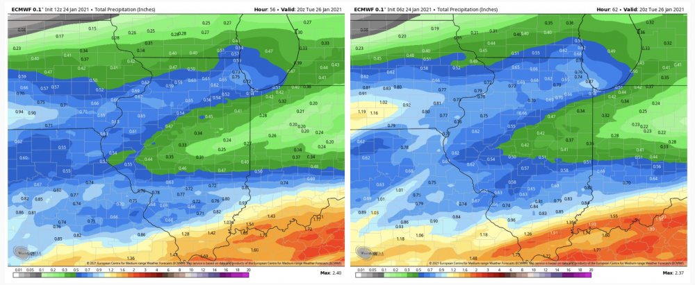
-
3km following suit.
Fringes always precarious, but funny to toggle between the 6z and 12z runs...and watch places on the northern edge going from warning snows to a trace.
-
Seems like we play these games of 0z run is south...6z north...12z back south...18z big bump north. Rinse, wash, and repeat.
-
FWIW, the 12z HRRR is solid for the city. Has the look of some LE action.
-
The more I think about it, pretty sure that's the formerly banned poster Ytterbium.
And way too much BamWx. Well, any is too much. And that pretty much goes for any of these twitter "mets".
-
4
-
-
2 minutes ago, Hoosier said:
Icy run again, even if you take 1/3 of what it is showing.
LAF gets its good. CMI even better.
-
2 minutes ago, Hoosier said:
It's a good run for that area verbatim, but I don't like the mid level low track. Would introduce dry slot concerns farther north than shown, imo.
It's all front end for here...other than scraps after the dry slot moves through. If it's all snow, then we (IKK) have a shot at 3-5" IMO. And I can see that happening...
-
Josh, cool idea. I've had the 6"+ list compiled for Chicago for quite awhile...you should have asked.
 Regardless, I've got a few corrections/added missing data to your list. Below are the ones that I have that are different from yours for Chicago...
1886-87: 2
1891-92: 3
1896-97: 2
1897-98: 2
1898-99: 0
1899-00: 2
1917-18: 3
1927-28: 3
1932-33: 2
1934-35: 3
1949-50: 1
1950-51: 2
1957-58: 1
1958-59: 2
1966-67: 3
1968-69: 1
1974-75: 3
1989-90: 2
2000-01: 3
2006-07: 2
2007-08: 1
-
2 minutes ago, vortex said:
I was sucked in for a second.
We can always hope for the dry slot to cut down rain totals. hahaLol, me too. Though I knew it was foolish. Nothing worse than 33 and rain while those just to the north are pounding snow. Alas, maybe it’ll keep Hoosier from posting those dumb drought maps.
-
1
-
 5
5
-
-
5 hours ago, Hoosier said:
I think the Canadian has been picking up on sleet too.
That sound you hear is my board brother throwing something at his screen upon looking at the 00z Euro sleet output.

Eh, I've been resigned to this not being a "clean" storm for here, for awhile. Would take a minor miracle for it to be all snow at this point. Overnight LOT AFD seems to indicate any freezing/non-snow frozen precip will be NBD here, with rain taking over. GFS hug, seemingly. Not sure I'd go that far yet, but further adjustments north might be the play...as they typically are with these types of systems. Oh well, onto to the next one for me I guess. Good luck to those up north...
-
1
-
-
I’ll I have to add is...Boiler Up!

")
-
1
-
2
-
-
Lock it up
-
1
-
-
And don't forget to stock them wagons.
Looks like another solid 33˚ rainer here. Congrats to the usual folk this winter.
-
10 hours ago, Hoosier said:
Yep. And it started with that storm on 2/6/07. What a nightmare that thing was on the roads because of how cold it was. The hilly roads were really challenging.
Yeah, super cold event. It was ripping +SN here in the single digits/low teens...all the while it was spring in Missouri.
-
3
-
-
9 minutes ago, Hoosier said:
At least we had a few really nice storms in LAF, highlighted of course by 2/13/07.
We had a really good run from Feb 2007 thru March 2015...save a few winters. Might be the best run LAF has ever seen.
Good times. When I get time, I may have to rank my favorites in this here thread.
-
2 minutes ago, Hoosier said:
We got shafted man.

Yep
QuoteTIPPECANOE- INCLUDING THE CITIES OF...LAFAYETTE 416 AM EST TUE FEB 1 2011 ...WINTER STORM WARNING IN EFFECT UNTIL 7 PM EST WEDNESDAY... .TODAY...BREEZY. PERIODS OF LIGHT FREEZING DRIZZLE AND CHANCE OF SNOW EARLY IN THE MORNING...THEN SNOW AND LIGHT SLEET LIKELY MIDDAY. SNOW AND CHANCE OF SLEET IN THE AFTERNOON. SNOW AND SLEET ACCUMULATION AROUND 3 INCHES. ICE ACCUMULATION OF LESS THAN ONE QUARTER OF AN INCH. NEAR STEADY TEMPERATURE AROUND 20. NORTHEAST WINDS 10 TO 15 MPH INCREASING TO 15 TO 25 MPH WITH GUSTS TO AROUND 40 MPH IN THE AFTERNOON. CHANCE OF PRECIPITATION NEAR 100 PERCENT. .TONIGHT...WINDY. SNOW AND CHANCE OF SLEET. AREAS OF BLOWING SNOW. SNOW MAY BE HEAVY AT TIMES. SNOW AND SLEET ACCUMULATION OF 8 TO 9 INCHES. ICE ACCUMULATION OF LESS THAN ONE QUARTER OF AN INCH. NEAR STEADY TEMPERATURE IN THE LOWER 20S. NORTHEAST WINDS 25 TO 30 MPH SHIFTING TO THE NORTH 15 TO 25 MPH AFTER MIDNIGHT. GUSTS UP TO 45 MPH. CHANCE OF PRECIPITATION NEAR 100 PERCENT. .WEDNESDAY...CLOUDY WITH SNOW LIKELY. AREAS OF BLOWING SNOW. SNOW ACCUMULATION AROUND 1 INCH. TOTAL SNOW ACCUMULATION 12 TO 15 INCHES. HIGHS IN THE LOWER 20S. NORTHWEST WINDS 15 TO 20 MPH WITH GUSTS TO AROUND 40 MPH. CHANCE OF SNOW 60 PERCENT.

Jan 25-26th Potential Something Part 3
in Lakes/Ohio Valley
Posted
10.3" (0.47" liquid) at DSM as of midnight. And been snowing since. What a winter for them.
Mood snows here this morning. Little bit of freezing drizzle overnight. Glaciated.