

Chicago WX
-
Posts
18,285 -
Joined
Content Type
Profiles
Blogs
Forums
American Weather
Media Demo
Store
Gallery
Posts posted by Chicago WX
-
-
2 hours ago, Hoosier said:
Re: GHD, anyone remember the wording out of IND about the ice potential? That office isn't really one to engage in hyperbole, but the statements were really strong. It ended up not being as bad as it could've been though because of sleet mixing in. I recall them live blogging during the storm... it was fun reading the frequent updates.
QuoteURGENT - WINTER WEATHER MESSAGE NATIONAL WEATHER SERVICE INDIANAPOLIS IN 138 PM EST MON JAN 31 2011 ...POTENTIALLY CATASTROPHIC WINTER STORM TO IMPACT CENTRAL INDIANA... .A STRONG LOW PRESSURE SYSTEM OVER THE WESTERN UNITED STATES WILL PUSH ACROSS CENTRAL INDIANA STARTING TONIGHT THROUGH WEDNESDAY. A VARIETY OF WINTER WEATHER IS EXPECTED WITH THIS SYSTEM. AS THE SYSTEM APPROACHES...COLD AIR WILL BE IN PLACE AT THE SURFACE...HOWEVER VERY WARM AND MOIST AIR WILL BE PULLED INTO THE SYSTEM ON SOUTHERLY WINDS...RESULTING IN WARM AIR ALOFT. THIS WILL RESULT IN FREEZING RAIN OR SLEET ACROSS MUCH OF CENTRAL INDIANA THIS EVENING INTO TUESDAY NIGHT. AS THE LOW PASSES TO OUR EAST EARLY WEDNESDAY MORNING...ALL OF THE PRECIPITATION WILL CHANGE OVER TO SNOW. AT THIS TIME...NORTH AND NORTHWEST CENTRAL INDIANA...INCLUDING THE CITIES OF KOKOMO AND LAFAYETTE LOOK TO REMAIN COLD ENOUGH THAT A SIGNIFICANT PORTION OF THE PRECIPITATION MAY FALL IN THE FORM OF SNOW. HOWEVER SNOWFALL MAY BE HEAVY AND SNOWFALL AMOUNTS IN EXCESS OF 12 INCHES ARE POSSIBLE BY WEDNESDAY EVENING. FARTHER SOUTH...INCLUDING THE CITIES OF TERRE HAUTE... INDIANAPOLIS...BLOOMINGTON...NEW CASTLE AND MUNCIE...WARM AIR IS EXPECTED TO BE PRESENT AND PRECIPITATION MAY FALL AS SLEET OR FREEZING RAIN. SIGNIFICANT ICE ACCUMULATION IS POSSIBLE...WITH ICE ACCUMULATION OF ONE INCH OR MORE. FURTHERMORE...STRONG WINDS GUSTING UP TO 35 MPH ARE EXPECTED FROM LATE TUESDAY AFTERNOON THROUGH WEDNESDAY AFTERNOON. THIS COMBINATION WILL RESULT IN WIDESPREAD DOWNED TREES AND POWER LINES. A LARGE AREA OF CENTRAL INDIANA MAY RECEIVE LARGE ICE ACCUMULATIONS AND STRONG WINDS BY WEDNESDAY AFTERNOON. THIS WILL RESULT IN WIDESPREAD TREES DOWN AND WIDESPREAD POWER OUTAGES. LONG DURATION POWER OUTAGES WILL BE POSSIBLE FOR MANY PEOPLE IN CENTRAL INDIANA. UNCERTAINTY STILL EXISTS WITH THE PRECISE TRACK OF THIS SYSTEM. ADJUSTMENTS IN THE TRACK IN LATER FORECASTS MAY HAVE SIGNIFICANT IMPACTS ON AREAS THAT MAY RECEIVE FREEZING RAIN OR SNOW. STAY ALERT TO THE LATEST FORECASTS FOR THE LATEST INFORMATION ON THIS POTENTIALLY CATASTROPHIC WINTER STORM
-
 1
1
-
-
Trailing band over us now, cotton balls falling. Best will be just to the north of here, but whoever gets under these bands for a time will do relatively well.

-
3
-
-
14 hours ago, michsnowfreak said:
With as boring as this Winter has been so far, I fully expected beavis to easily surpass his average meltdown quota, and that's fine but, but I just lol every time I hear 2013-14 was "decent". I know it was more severe in Detroit and Chicago but still, Chicago had like 225% of avg snowfall and temps like 8 degrees below avg. If you consider that Winter just decent, you will never ever be satisfied until you move to that Aomori, Japan (but warning, its probably not cold enough).
Dec-Mar 2013-14 is the coldest on record for Chicago. In the global warming era to boot. The 82.0" measured is the 3rd highest in history. Really it was the 2nd highest, due to measuring snafus at ORD. Calling the 13-14 winter "decent" is the definition of insanity. Won't see another winter like that around here, for a very long time.
-
4
-
-
Nice band on radar, just missing here to the north by mere miles. Looks like whoever gets under that, wins the derby in the LOT CWA. Think Hoosier has a good chance.
We did better than expected here yesterday morning, so guess we can't win them all.

-
1
-
-
Some real nice bursts of snow here this morning. Snow globe at times. Everything covered up. Regardless of real cold air, wintry appeal the next couple of days. Better than nothing....
-
2
-
-
Parachutes. Really coming down at the moment. Kind of a fun little event.
-
2
-
-
Snowing here. So we’ve completed the winter trifecta today.
-
1
-
 2
2
-
-
1 minute ago, Hoosier said:
Our old "friend" the LAF ASOS is reporting freezing rain at 35/34. That's a pretty good trick.
Lol, I saw that. I’m sure Chad’s all over it...
-
2 minutes ago, vortex said:
Read that too. Definitely not even close to melting.
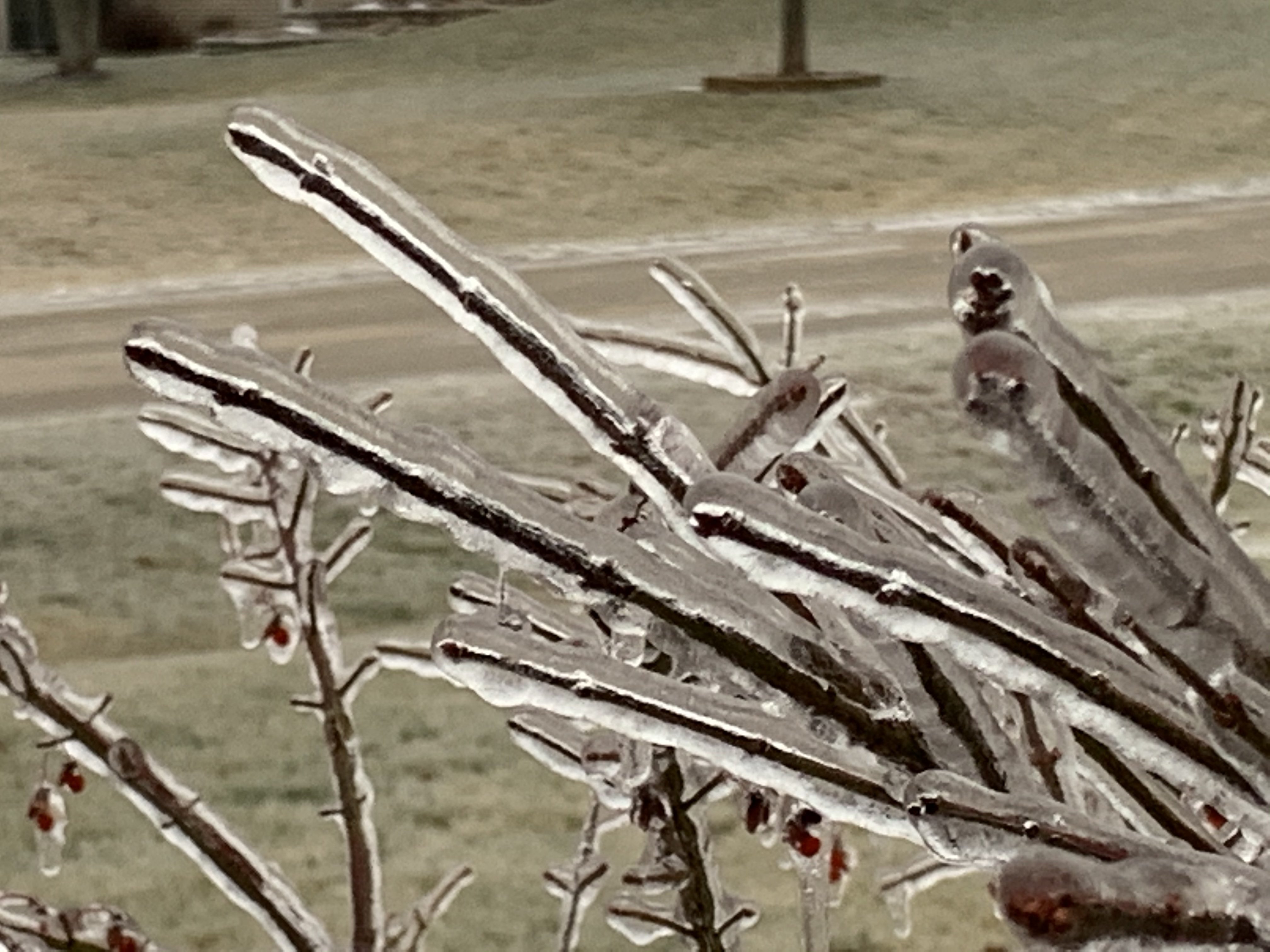
Just took this pic.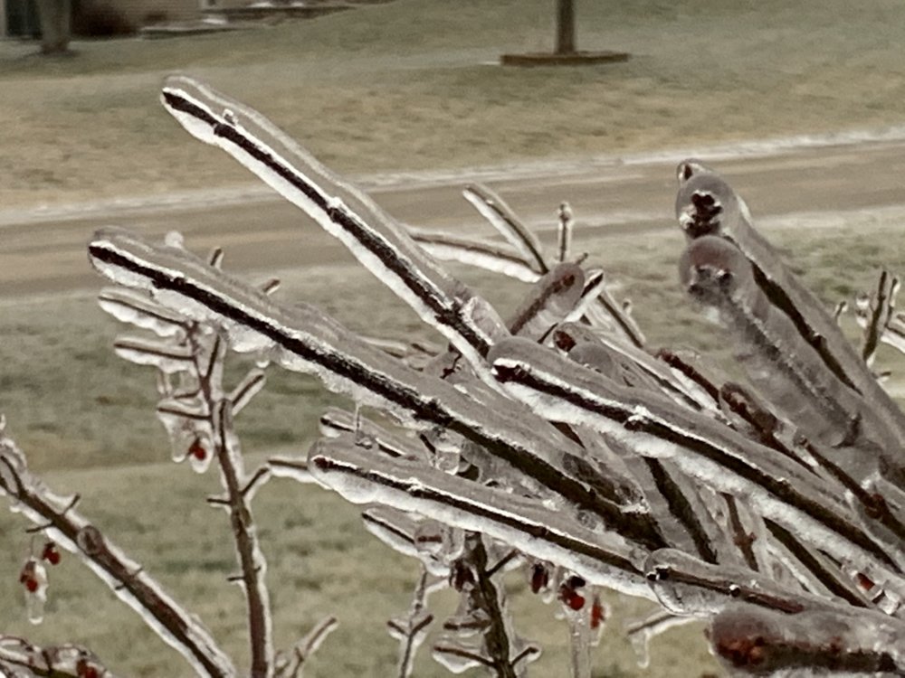
Nice pic. Was just out in the back listening to the trees crack in the wind. Not comforting.

-
Finally made it to 32˚ here at my house, a couple of hours ago...and been that way since. No melting. Of course, just read LOT's AFD and they said all the ice melted south of I-80.

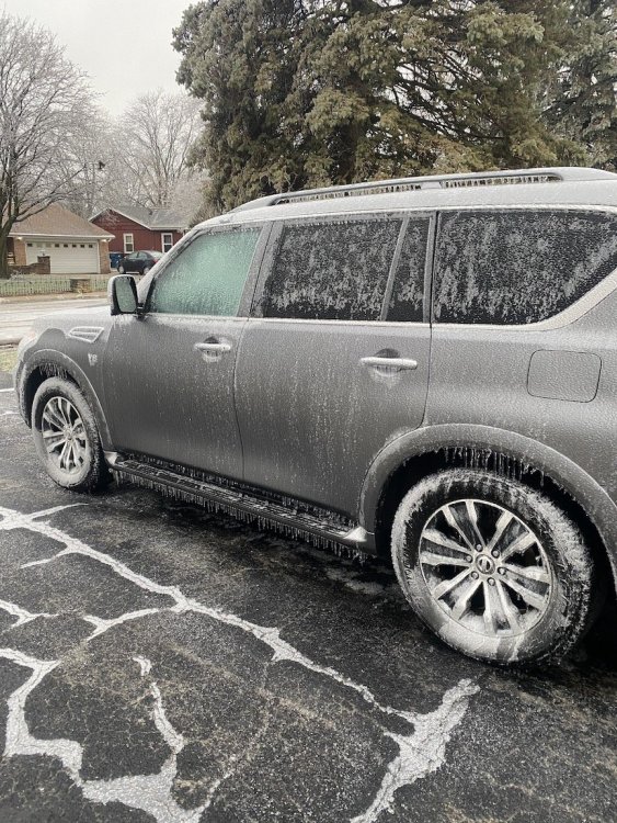
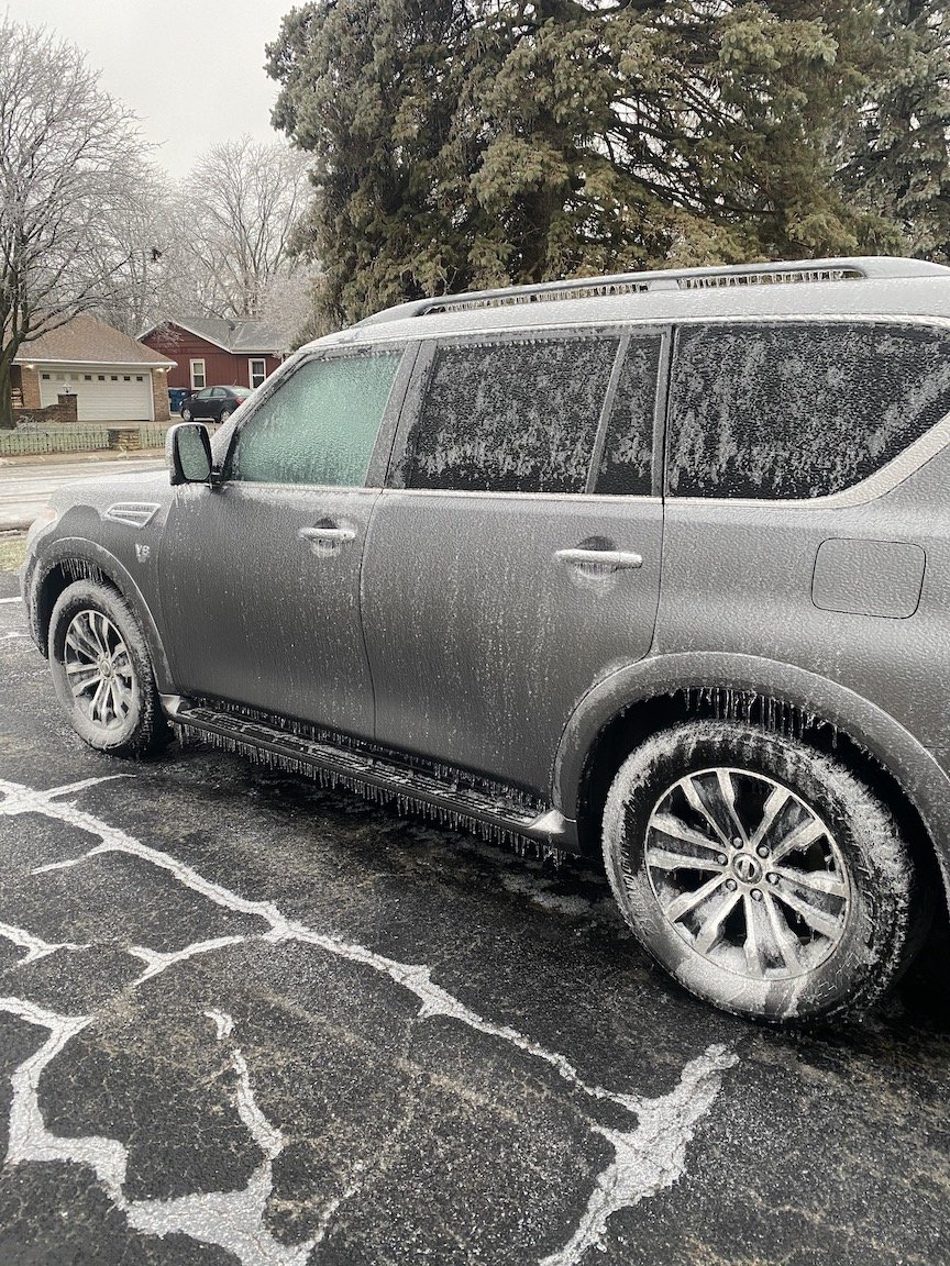
Just took this shot of the gf's car. Totally encased.
-
6
-
-
1 minute ago, michsnowfreak said:
Howdy stranger. Welcome back and please stay!
What's up Josh.
")
Don't have as much time anymore, but when things get interesting, I'll stop in.
-
1
-
-
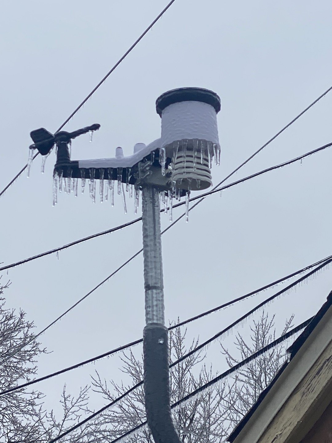
Photo of my weather station.

-
9
-
-
1 minute ago, Hoosier said:
Thankfully it's a federal holiday, right?

Today, yes!
-
5 minutes ago, Hoosier said:
Come on Kankakee crew, we want some obs.
Everything encased in ice here. Started as some pretty heavy sleet this morning, then went to freezing rain about 8:30. Trees are creaking with every movement of the wind. Temp is 31˚ at mi casa currently. Actually got a real weather station now, lol.
Even with probably getting to or a bit above freezing this afternoon...tomorrow is going to suck. Alas, hoping for a little snow here as this thing exits stage right.
-
2
-
-
Very large limb down off one of my trees. Just missed the house, thankfully. Had a brief uptick in big winds, along with a close lightning strike. Not sure which one got the tree. Pool has a ton of leaves too. Rest of the neighborhood is littered with your usual high wind small limb damage.
-
1
-
-
9 hours ago, bowtie` said:
Someone is not going to be happy about basement flooding.
lol, I'll own that. All good here though. Was put under a FF Warning at 4:30 yesterday...and ended up with 0.25" total. To my south and southeast, not so good though. Saw a report of 7.76" from Kentland IN. That's a lot of water, in a short amount of time.
-
2
-
-
Wouldn’t be summer without Hoosier calling for drought and endless heat. He’s the summer version of winter JB.
This dry stretch has been fantastic though. Keep it coming.
-
 1
1
-
-
Trees down on my route. And not just small trees, soMe big ‘ems going down. Couple of streets closed because of them. This is kinda dangerous.
-
4
-
-
2 minutes ago, King James said:
Hang in there man, looks like a big one comingTired of it. My neighbors have servo pro over cleaning their basement. Dumpster in the driveway because they had to throw everything away. And we’re doing it all again. Enough is enough. IKK can’t take anymore. It’s disgusting.
-
 1
1
-
-
15 minutes ago, janetjanet998 said:
do they live directly in town?
Yes
-
Welp, time to get over to my parent's house and starting pumping water...again. IKK going to get absolutely crushed...again. Over and over. Year after year. This weather freaking blows.

-
Total and complete devastation here. Going to pull an all-nighter to try to save my parents basement. Thought installing the sub pump in 2015 would help, but this has overwhelmed it. This is sickening. So f*cking tired of this, year after year...
-
4
-
-
45 minutes ago, Hoosier said:
The good old days

We pray
-
2
-
-
3 hours ago, King James said:
We had a bunch of roads closed out this way yesterday. River went up over the road back near Sun River Terrace. Interested to see if this area can handle more rain, getting around yesterday was annoyingNope, can’t handle anymore. Another 2-4” will pretty much finish things. Juggling working 12 hour days and helping my parents suck water out of their basement is tiring. And they have a sump pump. This is going on 6 years of unprecedented rainfall in IKK. Need a drought badly...
-
1
-
1
-

Snowstorm Reminiscence Thread
in Lakes/Ohio Valley
Posted
We got 9" from the Dec 11, 2000 storm here...was forecasted for lower amounts due to mixing that never materialized. And then 2 days later we got 6" with another storm. Thereafter, like Hoosier said, it seemed like it snowed every day that month. It was quite a wintry scene through the end of that month. And then winter ended. Didn't get warm, but we went bone dry.