

Amped
-
Posts
14,197 -
Joined
-
Last visited
Content Type
Profiles
Blogs
Forums
American Weather
Media Demo
Store
Gallery
Posts posted by Amped
-
-
Already northeast of the forecast.

-
 1
1
-
-
Also, the Euro is 20mb deeper than the gfs at 24hrs.
-
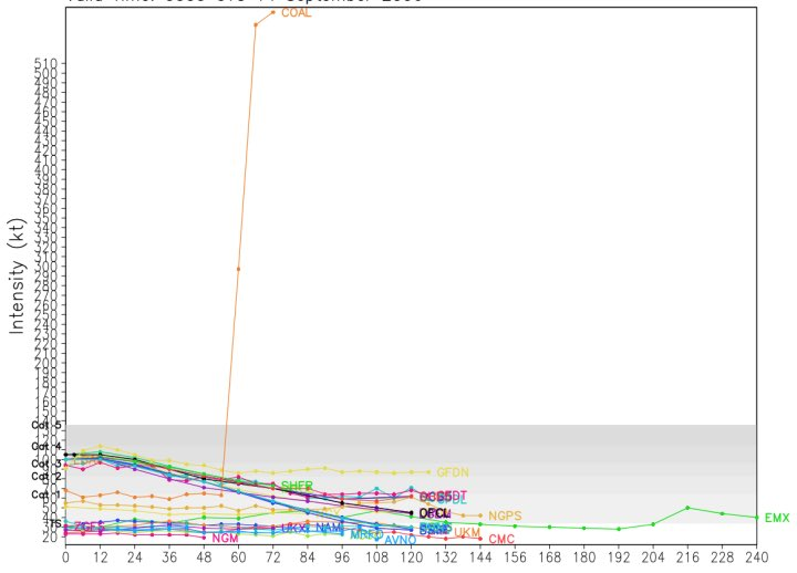
Hurricane models are showing it takes at least 48hrs before any signifigant deepening resumes. How strong it gets may depend on how long it avoids landfall. Most likely it gets back to a cat1 or cat2.
-
Beryl has produced 27.7 ACE so far. Amazing for a July storm. Will probably top 30 when all is said and done.
https://tropical.atmos.colostate.edu/Realtime/index.php?loc=northatlantic
-
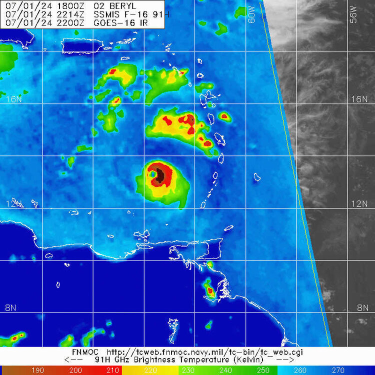
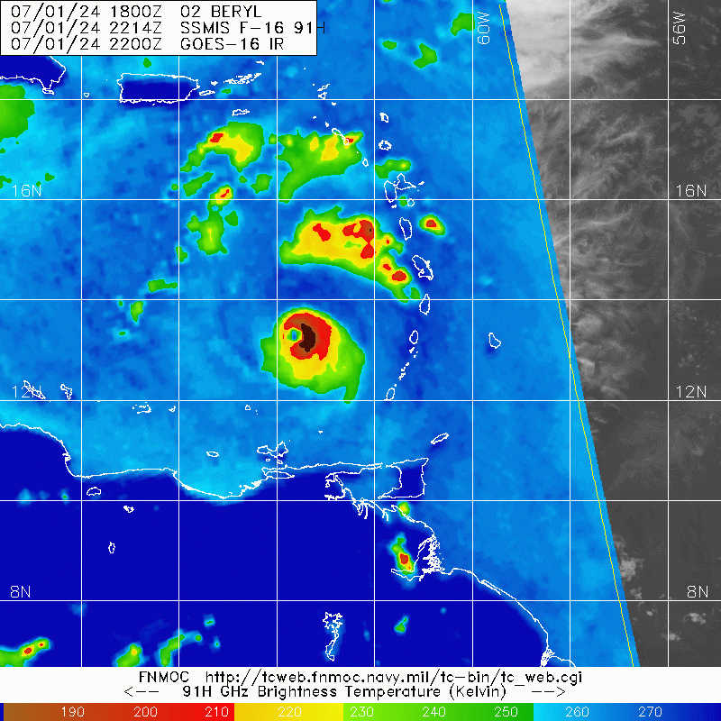
Shear is really cranking now. You can see it on IR and the S eyewall is open on radar.
-
10 or 15 miles will make a big difference in the outcome for Kingston. 18z tracks are pretty close to a direct hit.
-
4
-
-
15 minutes ago, GaWx said:
The high Jamaican mtns will almost certainly disrupt and weaken Beryl at least while over it or passing it. How much and for how long is the big question. It has mtns over 7K feet high in the E portion!
Almost before Gilbert left the island, it started to rapidly strengthen. Then that storm became a monster.
Yeah probably comes off Jamaica a cat 1 or strong TS. Hurricane models showing a pretty messy structure near the Yucatan.
-
 1
1
-
-
The shear is patiently holding off until 3 minutes after the upgrade.
Edit: It's official now, 160mph at 11pm
-
2
-
-
10 minutes ago, Boston Bulldog said:
SSMIS does suggest that there is indeed westerly shear impacting the core already. Lots of convective activity in the east eyewall, can Beryl wrap it upshear and rebuild out west?
Seems to be doing a very good job of that so far. Wouldn't know there's any issues on the west side of the storm from the IR presentation.
-
9 minutes ago, Radtechwxman said:
I think would have been different story if they had flown a mission hours ago. I think they might have just missed the peak of Beryl. Regardless still an absolute monster for July.
The appearance has been steady for the 5 hrs or so. Maybe the next pass will be more conclusive.
-
2
-
-
8 minutes ago, Windspeed said:
The central pressure given the background environment and the flight level wind reduction alone would support a 160 mph hurricane if the NHC chose to upgrade. That being said, it appears something is off with the SFMR instrument.
It is dropping out intermittently might have missed the max.
-
Latest recon pass is nuts. Hope that's an error.
-
9 minutes ago, WxWatcher007 said:
Didn't think there was going to be an ERC today, dry air is inhibiting the ability of the core to expand at this time, and the core usually expands prior to an ERC.
-
The ADT numbers have leveled off the last few hour,s so the intensification may have plateaued for now. Hurricane models did show some brief dry air intrusions over the course of the day.
-
1
-
-
4 minutes ago, dbullsfan said:
I’m with you guys as well, but I’m not so sure Josh isn’t playing it smart on this one, showing up last minute to what could be a cat 5 or close to cat 5 storm on a very small island, even in the most secure structure for a guy with a lot of money is a risky proposition. The data and everything would be amazing and I know these guys go into risky situations but sometimes you gotta know when you messing with a beast that isn’t normal.
.The islands are difficult to chase because you can't reposition without getting a boat or plane. The Yucatan is more chasable.
-
3 minutes ago, hawkeye_wx said:
960 mb extrap, 132 kt SFMR on latest recon pass.
Insane, stronger than any of last nights hurricane models.
-
1
-
 1
1
-
-
50 minutes ago, cptcatz said:
5 mb drop in an hour...


Its even ahead schedule for my bullish call from last night. Going to break the June record by mid afternoon at this pace.
-
HAFS-B has 128kt 953mb peak at 09z Monday. That wind maybe a little high given the pressure. HMON is 953mb 117kt at 06z Monday.
-
1 hour ago, Amped said:
The June record for a basin hurricane is 946mb 125mph. Beryl has 25 hrs and 55 minutes left.
So far so good, you got this Beryl, it's all yours, just keep it the pace.
-
 1
1
-
-
The June record for a basin hurricane is 946mb 125mph. Beryl has 25 hrs and 55 minutes left.
-
1
-
-
5 minutes ago, CurlyHeadBarrett said:
bruh
Gonna extrapolate that to 600kts.

-
5
-
-
2 hours ago, pazzo83 said:
8pm:
DCA: 92F
IAD: 91F
BWI: 90FHighs today:
DCA: 99F (R)
IAD: 98F (R)
BWI: 97F (R)
RIC: 99F
CHO: 97F
ORF: 99F (R)Crappy night. Not even going to make the forecasted 75 low
-
A couple cells forming now in Frederick and northern Carroll counties.
-
Rain just lifted In downtown columbia. No tornado or damage visible from my window.

Hurricane Beryl - Hurricane Warning - Baffin Bay to San Luis Pass Texas
in Tropical Headquarters
Posted
Icon not backing down from 12z. Earlier landfall in almost the same location with a slightly lower pressure.