

WeatherMonger
-
Posts
715 -
Joined
Content Type
Profiles
Blogs
Forums
American Weather
Media Demo
Store
Gallery
Everything posted by WeatherMonger
-
Just upgraded to a high wind warning here for gusts to 60. Had a 54mph gust last hour according to airport.
-
Midwest/Ohio Valley/Great Lakes Snow January 24-26
WeatherMonger replied to Baum's topic in Lakes/Ohio Valley
ILX cracking me up. Sadly I don't know if they are correct and LSX is a bit agressive, but the advisory map lools funky Think they could have at least issued an advisory this afternoon. Lackluster system at best for here regardless, don't want a 2nd half of winter 1st half spring winter. -
Midwest/Ohio Valley/Great Lakes Snow January 24-26
WeatherMonger replied to Baum's topic in Lakes/Ohio Valley
My works Christmas party got canceled due to the pre Christmas "storm" on 12/22. Just announced earlier this week it is rescheduled for 1/25. Holding out hope they have to cancel yet again -
Pre-Christmas (Dec 21-23rd) Winter Storm Part 2
WeatherMonger replied to Chicago Storm's topic in Lakes/Ohio Valley
Merry Christmas everyone!! -
Pre-Christmas (Dec 21-23rd) Winter Storm
WeatherMonger replied to Chicago Storm's topic in Lakes/Ohio Valley
ILX latest on it. Calling 1-3" conservative for now. .UPDATE... Issued at 1009 AM CST Tue Dec 20 2022 The main change this morning is an earlier peak in wintry precip seen in the latest model guidance, which is now forwarded about 6 hours. In other words, the most robust snowfall rates appear to come Thursday afternoon and extend through the Thursday evening commute. Snowfall rates may approach 1"/hr for a brief time, and with winds whipping at 35-45 mph, visibility will significantly deteriorate. Blizzard-like conditions will make travel extremely difficult or impossible Thursday evening. Then, as snow begins to taper Friday morning, blowing and drifting snow has the potential to prolong travel impacts into Saturday morning. At this time, our posture hasn`t changed much on the strong winds and extreme cold. We remain conservative on snowfall amounts with 1-3" inches likely (90% confidence) across the Winter Storm Watch area. The potential for 6" + is still lurking under any sort of mesoscale banding, but realistically, we need another 12-24 hours before we try to pinpoint where that heavier axis will develop. This is when some of the hi-res ensemble guidance (HREF model) will come available for us to better resolve mesoscale banding. -
Pre-Christmas (Dec 21-23rd) Winter Storm
WeatherMonger replied to Chicago Storm's topic in Lakes/Ohio Valley
I'm not excited either, one thing that has a bit of optimism going for me is the OP, CS doesn't make fantasy threads or overhype. I always pay attention when he starts them. Still remember the monster clipper from accuwx days, he started the thread less than 48 hours out when no one else had mentioned it, it had WSWarnings from IA into OH with 6"+ totals, had to have been '07-'09 or thereabouts. Miss the historical data that site had in it. Forever lost. -
Pre-Christmas (Dec 21-23rd) Winter Storm
WeatherMonger replied to Chicago Storm's topic in Lakes/Ohio Valley
Truthfully, I cannot remember the last time this year I was excited about the weather ahead. It has been that benign for so long, I've grown accustomed to yawntivity throughout the atmosphere -
Pre-Christmas (Dec 21-23rd) Winter Storm
WeatherMonger replied to Chicago Storm's topic in Lakes/Ohio Valley
I think I'll hold off until HRRR range and then wait for the last minute adjustment, NAM has broke my heart more times than I can count inside of 48 hours -
Pre-Christmas (Dec 21-23rd) Winter Storm
WeatherMonger replied to Chicago Storm's topic in Lakes/Ohio Valley
ILX AFD .LONG TERM...(Wednesday through Saturday) ISSUED AT 249 PM CST Sat Dec 17 2022 The focus for this period continues to be: (1) Extreme cold; (2) Strong winds; and (3) Some snow. Extreme Cold: Confidence remains high that an arctic outbreak will occur in wake of a departing winter storm system Thursday - Saturday. Deterministic NBM guidance is suggesting daily highs in the low teens or single digits with overnight lows near or below zero. These temperatures, coupled with strong winds, will result in wind chill values of 10-30 degF below zero both Friday and Saturday mornings. Surprisingly, as cold as its going to get, it will fall well short of records. Less extreme cold returns following Christmas day, but temperatures will remain well below normal for this time of year. Winds: Strong baroclinicity and a rapidly deepening surface low will result in very gusty winds Thursday - Saturday across the Midwest. Sustained speeds between 20-25 mph will be accompanied by frequent gusts between 30-40 mph. There is now enough semblance among guidance to make this a high confidence threat. Snow: While the 12z GFS and its suite of ensemble guidance has come into better alignment with the CMC, ECMWF, and UKMET with regards to a closed, upper-low evolving across the Midwest on Thursday, there are still notable differences with respect to amplitude, timing, and orientation of this feature. The most probable outcome for central Illinois at this juncture favors the Grand Ensemble mean, which paints about 0.25" of QPF across our area. With a snow ratio of 12:1, this puts us at a few inches of accumulating snow. At this point, with such high variance among forecast guidance, it does little good to provide synoptic and mesoanalysis of what could happen 5-6 days out. But looking at the conceptual model of the system, there`s a strong likelihood that somebody across the Midwest gets hammered by this one. -
Pre-Christmas (Dec 21-23rd) Winter Storm
WeatherMonger replied to Chicago Storm's topic in Lakes/Ohio Valley
ILX pretty late with their AFD. Late morning update ended with this. Edit, N/M garbage phone having caching issues. Checked with other phone and it was put at 2:49 -
2022 Short/Medium Range Severe Weather Discussion
WeatherMonger replied to Chicago Storm's topic in Lakes/Ohio Valley
Guessing by the lack of ppsts today is much ado about nothing, but with as boring as this Spring has been here I'll take anything I can get. Could probably count on one hand the days I have heard thunder thus far. -
2022 Short/Medium Range Severe Weather Discussion
WeatherMonger replied to Chicago Storm's topic in Lakes/Ohio Valley
Expansive slight risk added -
2022 Short/Medium Range Severe Weather Discussion
WeatherMonger replied to Chicago Storm's topic in Lakes/Ohio Valley
Think you just needed to click on APX star -
2022 Short/Medium Range Severe Weather Discussion
WeatherMonger replied to Chicago Storm's topic in Lakes/Ohio Valley
Bit odd seeing a pulse squall line, thing has made very little progress east as it starts to weaken in the midsection. Was worried about some dirt track races getting rained out, shouldn't be a problem at all. At least for the ones I'm wanting to watch. -
2022 Short/Medium Range Severe Weather Discussion
WeatherMonger replied to Chicago Storm's topic in Lakes/Ohio Valley
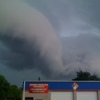
2 confirmed tornados ongoing in west central IL. No watch out and SPC doesn't even have 2% chance in SWODY 1 -
2022 Short/Medium Range Severe Weather Discussion
WeatherMonger replied to Chicago Storm's topic in Lakes/Ohio Valley
Currently 73/61 here -
Enhanced dropped from central IL just as the sun comes out to laugh. If it isn't cleared out by 8:30am anymorr I lose hope, and even then we usually get a surprise capping. Give me some thunder amd I'll be contemt.
-
Large moderate introduced for tomorrow
-
2022 Short/Medium Range Severe Weather Discussion
WeatherMonger replied to Chicago Storm's topic in Lakes/Ohio Valley
Think I found the culprit, synoptic winds howling right now so doubt they try fixing it tonight. -
2022 Short/Medium Range Severe Weather Discussion
WeatherMonger replied to Chicago Storm's topic in Lakes/Ohio Valley
Warned now, wonder if airport recorded a gust or widespread power outage prompted it -
2022 Short/Medium Range Severe Weather Discussion
WeatherMonger replied to Chicago Storm's topic in Lakes/Ohio Valley
Power went out here as thunderstorm moved in, not sure if it was a bit of mixing down or high synoptic winds earlier created something for the rain to take advantage of. Bit of thunder but not much. Oil lamps are something not many have or appreciate anymore. Glad I have a few. -
Precip has arrived, falling as snow pellets at a good clip. Better than freezing rain and/or sleet.
-
Misting here, not flurries. Might get a bit more freezing rain than expected.
-
You get any thunder today? Got woke up about 4:10 this morning with some good thunder and lightning, then torrential bursts of rainfall. Radar estimates of 1.5" but airport recordings overnight have been down for a while now. Either way, been a long time since a good thunderstorm. I'll trade snow for that any day.
-
Nothing left but drifts and plow mounds here. Currently have exhaust fans and doors open at work, won't be long before snow becomes a hinderance. March 15th is my transition to Spring mode, but I know there'll be cold and possibly snow after that.


