

WeatherMonger
-
Posts
644 -
Joined
Content Type
Profiles
Blogs
Forums
American Weather
Media Demo
Store
Gallery
Posts posted by WeatherMonger
-
-
Well crap, guess I put the jinx on

-
 1
1
-
-
44 minutes ago, StormChaser4Life said:
Globals really struggle with these clippers and underestimate what high ratios with minimal moisture can do. Hrrr/rap have been pretty consistent.
Been awhile since we've had a good clipper. I'll take the HRRR or SREF plume any day, any year. When we get them we usually do overachieve. Hoping for some good 24 hour trends beginning with tonights runs. With these arctic temps coming, it has to over perform for us(wishcasting). Hoping 21Z SREF continues the upward trend.
A bit of the other thread but still nearly 5" tomorrow

-
Has switched to snow here, about an hour or two earlier than expected. Likely too warm yet for it to accumulate though.
-
Very light rain still falling here at KSPI but every few seconds a single large white drop will fall as snow tries to mix in.
-
2 hours ago, StormChaser4Life said:
Cue that happening because so far this winter everything has missed me north so only logical that next it would miss me south. Lol. Hoping I can squeeze a few nice fluffy snows out of this sustained cold pattern. Would be a waste to not put this quality cold air to work
")
I can't remember the last arctic punch here that did not have a somewhat sufficient snow pack. Cold or bust....

-
 1
1
-
-
2 hours ago, Brian D said:
I don't get into my methods. I keep that close. I'm not trying to BS anyone, just having fun with this hobby. Have been doing it off and on over the years. I don't charge anything for forecasts like some out there do. I try to be honest and if I blow it, I own up to it. Whatever you wish to think about what I do, or how good or bad I am at it, I'll leave up to you.
Thanks for your interest, and if the forum wishes me to stop doing this, I'll respect their wishes.
No worries man, up until your 3rd-5th thread and seeing you mention it in a post on this thread I haven't seen your other predictions and how they have panned out.
You said "your model" so I figured you had somehow delved a way to incorporate an algorythm/program to actually forecast. We never know who we are really interacting with on the internet, you could have the wealth of Bezos for all I know and have your own weather predictor
I like your terminology in this post a lot better in using "method" rather than model, in weather forecasting the difference in definition is vastly different.
Good luck with it, and if it works it works. If not, try and try again.
-
2
-
-
1 hour ago, luckyweather said:
everything he “models” is long range so my money is on teleconnections a la beiring sea rule or lezak recurring cycle or an “all blend” of both making “Brian’s proprietary model” copyright 2021
ps no diss Brian, while your maps are vague with farmers almanac levels of leaving yourself open to being accurate no matter what happens you have had some ringer level hits this season
That was my initial impression as well, mentioned them in one of the other threads as well.
I think there is a little credence to all of them in their own rite, but to call a theory a model is a bit much. I'll end it at that as I've come to acknowledge they're(other theories) not well received here for scientific purposes. No issue with that either, I just love to be prepared for what lies ahead regardless the means, and morseo use the greater knowledge of everyone involved to keep friends and family safe days in advance.
For all I know he was Musk or Bezos and had supercomputers with an alias to keep it on the downlow
-
1
-
-
56 minutes ago, Brian D said:
I think this is going last a bit longer overall now that I've looked more at my model, especially my way. A little reprieve in there but overall, pretty much the dead of winter. I did mention how really cold Feb looked in my forecast for the upcoming month . Looks like it'll pan out with big storms afterward like Valentines Day that I have noted. We shall see about that.
Can you post some more about your model? What is it and how do you ingest data and such? Couldn't imagine the specs of a computer to accomplish such a feat at home. I recall Skilling used to state he had an inhouse RPM model, similar?
I've been a lurker during my first umpteen years here and have not followed along with every system thread since then, until this year(Winter season). May have missed it, but I'm curious whether to add more weight to your postings or if it is a bit of BS.
Not calling you out on it, just want a bit more info if you could.
-
2
-
 1
1
-
-
31 minutes ago, Brian D said:
Well, I hope you guys enjoy. My model did ok showing this system. Thought it had a better chance coming my way. Oh well, 3-6" of powder before the Arctic relocates is ok too. Snow pack good enough to handle the cold, which is a good thing.
Go for it Cheese Heads and Polar Bears lol !
What is "your model"? Keep seeing you reference it but only image you have posted is a paint rendered image. Are you referring to something like LRC/BSR/Heady Pattern?
-
36 degrees and closing in on .5" of rain .

Here's to the Big Dog........

-
 5
5
-
-
Took me a minute, but think I just got rid of the heart attack inducing sound for a notification. That thing has scared the crap out of me more times than the DGEX let me down....
-
4 minutes ago, pondo1000 said:
ILN dropping what watches? I didn’t see any watches from them?
QuoteWinter Storm Watch
URGENT - WINTER WEATHER MESSAGE
National Weather Service Wilmington OH
331 PM EST Fri Jan 29 2021

INZ050-OHZ026-034-035-042>045-051-052-301000-
/O.CON.KILN.WS.A.0001.210131T0000Z-210201T1200Z/
Wayne-Hardin-Mercer-Auglaize-Darke-Shelby-Logan-Union OH-Miami-
Champaign-
Including the cities of Richmond, Kenton, Ada, Celina, Coldwater,
Wapakoneta, St. Marys, Greenville, Sidney, Bellefontaine,
Marysville, Troy, Piqua, Tipp City, and Urbana
331 PM EST Fri Jan 29 2021

...WINTER STORM WATCH REMAINS IN EFFECT FROM SATURDAY EVENING
THROUGH MONDAY MORNING...

* WHAT...Heavy wet snow possible. Total snow accumulations of 5
  to 8 inches possible.

* WHERE...Portions of East Central Indiana and Central and West
  Central Ohio.

* WHEN...From Saturday evening through Monday morning.

* IMPACTS...Travel could be very difficult to impossible. The
  hazardous conditions could impact the morning commute.

* ADDITIONAL DETAILS... The heaviest snow will fall on Saturday
  night into Sunday morning.

PRECAUTIONARY/PREPAREDNESS ACTIONS...

Monitor the latest forecasts for updates on this situation.
-
2 minutes ago, mimillman said:
Here’s the 18z Euro 10:1. I refuse to post the weenie kuchera in order to avoid mass hysteria in LOT
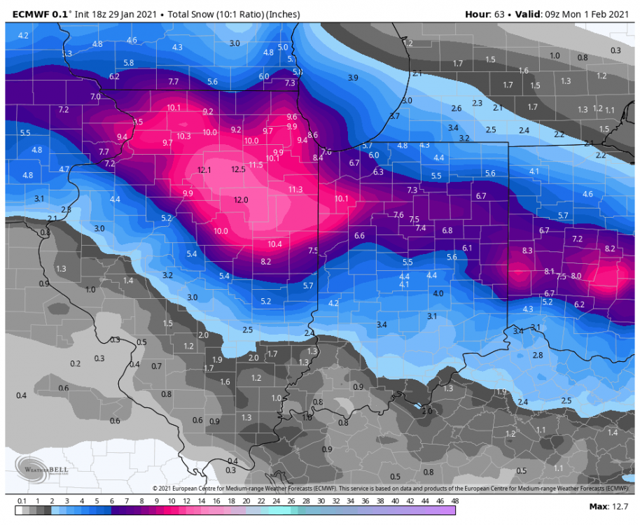
Silently(until now) been rooting for the Euro, it has been consistent at giving me measurable snowfall, but feel it's an outlier in that regard.
-
One of these day... err years, it's gonna happen here again
-
10 minutes ago, StormChaser4Life said:
Anyone have the 18z Kuchera map for Euro? I'm not sold on 10:1 ratios this south. More likely north of I80 in colder air and the more intense mesoscale banding.
Thinking about breaking out the smoker tomorrow to empty the freezers. Gonna pack as much backyard snow as I can in them and go rent a wood chipper for Sunday evening to put it back down.
I'm struggling for ideas here
-
1
-
2
-
-
1 minute ago, Chambana said:
Anything that has a CMI screw hole is money. Another cold Rainer incoming for central Illinois.
I'll take your winter screw hole in exchange for your severe weather bullseye
-
1
-
-
22 minutes ago, SchaumburgStormer said:
Been a long time since we have had this kind of agreement. Lets start bumping the QPF and make er a big dog.
Can we compromise and keep QPF as is and have the cold air more prominent further South? It would benefit you just the same by increasing ratio rather than moisture content.
That said, only good thing about this system is it puts me one closer to the next big one here. Who knows how long that will take though
-
3
-
1
-
-
Official tally 3.2". Season total of 9.3" all in January. See what February can muster up
-
Ended up a bit of an overachiever here, very comfortable saying 2 1/2" but feel it may be closer to 3". Hard to tell with the drifting that took place. Definitely better than 10:1 ratio, would guess 13-15:1, was an easy shovel when I got home.
Will be our highest event total for sure on the season. I'd trade it for the weekend heavy band in a heartbeat though.
Drive home looked like IDOT may have been caught a bit off guard locally.
Onto the next one.
-
4
-
-
Snow/flurries started here about 10 minutes ago.
If we can manage 1.4" it would be the biggest single day snow of the season.
Pretty sad saying that on January 27th
-
3 hours ago, StormChaser4Life said:
That has definitely been the story of this winter. A very persistent storm track in all directions around us. I'm ready for tornadoes by March so these snowstorms need to start happening between now and Feb
March is a bit early please
I'll take snow up until the first week of April, hail is the only wished upon frozen precip after that.
-
2
-
1
-
 1
1
-
-
1 hour ago, StormChaser4Life said:
Yea not even get remotely invested in this till Fri or Sat. About this time with current storm I was in bulleyes then to Iowa it went. Lol. Hopefully this storm won't putter out as fast as this current storm. Sad we can't get strengthening storms this winter. It's like well I hope this one will weaken slower. Lol. But here's to Euro/Gem being right! Would be nice to see areas south of I80 get some love for a change
but can't deny trends this winter so I'm sure it will find a way to push north.
Just hope in the end to say, " Man, the Euro nailed this at 5 1/2 days out"
I know better though....
-
1
-
3
-
-
52 minutes ago, StormChaser4Life said:
Looks like a nail biter as usual here. Hoping for a south trend usually doesn't end well unless it's a clipper. I'm on the southern end of most guidance now. Guessing for a near miss to the north. Would be nice to get big snow but as long as I don't get cold rain I will be semi content.
I'd rather live where you are than here, if I had to remain in IL. Galesburg is where I would want to live for the weather bonus Capitol of the state. They get it all and rarely misses them for a season. Severe or winter weather, Galesburg is always close to an epicenter it seems.
-
1
-
1
-
-
4 minutes ago, mimillman said:
Once again some solid hits on the EPS. E14 anyone?

03 please, but I'll take my cold rain and like it......
-
1
-


Feb 6-7 storm?
in Lakes/Ohio Valley
Posted
SREF plume didn't change a whole lot. 4.5"