

WeatherMonger
-
Posts
644 -
Joined
Content Type
Profiles
Blogs
Forums
American Weather
Media Demo
Store
Gallery
Posts posted by WeatherMonger
-
-
Just now, miamarsden8 said:
15:1 could be possible though yeah? Because at 15:1 even that's absurd.
I wish I could answer that with an educated response, but I cannot and will not try to. Probably should not have earlier, but I'm drinking myself to sleep tonight and felt pretty smart

Hopefully it produces for you regardless, enjoy it and treat it like the last is all I can suggest.
-
8 minutes ago, miamarsden8 said:
So if that's the case, I'd argue Cincys total is probably closer to 12 than the forecast 6-9. My call of 6-10 might be lower that it should be.
By Cincy's forecast you are expecting 7.5" on .78" QPF which is a shade under 10:1 ratios. Probably should not assume 20:1 ratios there, it's all about the thermal profiles throughout the atmosphere amongst other things I am not qualified to speak for.

-
Just now, miamarsden8 said:
Would 20:1 give us better snow totals or?
Always, when in relation to QPF amount. typical snowfall at 10:1 gives 10 inches of snow to 1 inch of precipitation. Get that to 20:1 ratios and you're looking at 20 inches of snow from the same precipitation.
Last snow here we had 50:1 ratios, which would equate to 50 inches of snow per the same QPF. Way different thermal profiles here though, but should be in the 12:1 to 20:1 for most with exceptions for a few.
-
Just now, Jim Martin said:
More than 20:1 snow ratio there.
Yeah, not by much though. Would be nice to get that QPF with a good clipper. Hope it pans out or even over achieves, tomorrows high is only 6 degrees coming off an overnight low forecast at -1. Not sure what to think with the surface low so far from the cold sector, I'd take improved ratios over more QPF any day, easier to shovel and disappears quicker when it does warm back up.
-
6.8" snow on .30" QPF in the hourly grids

-
RECORD EVENT REPORT
NATIONAL WEATHER SERVICE LINCOLN IL
0501 PM CST SUN FEB 14 2021
...RECORD COLD HIGH TEMPERATURE SET AT SPRINGFIELD IL... A RECORD COLDEST HIGH TEMPERATURE OF 4 DEGREES WAS SET AT SPRINGFIELD IL TODAY. THIS BREAKS THE OLD RECORD OF 15 SET IN 1943.
-
-
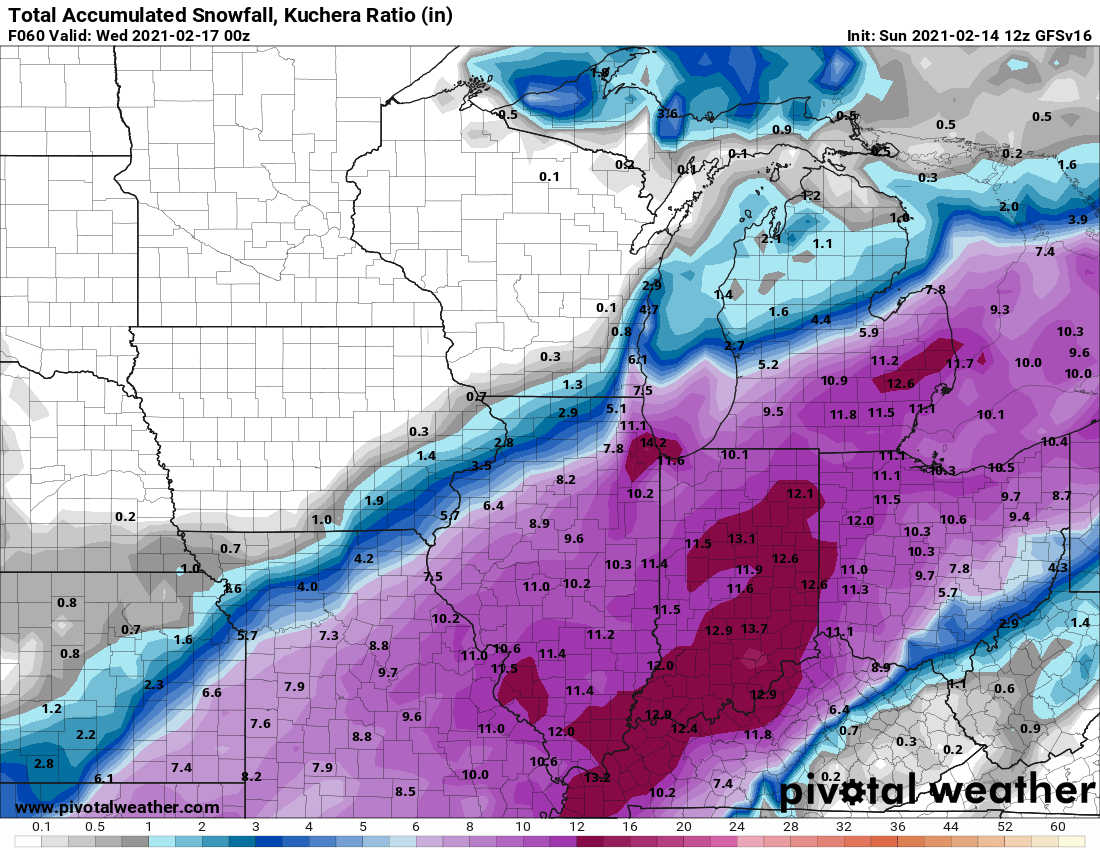
2 minutes ago, RCNYILWX said:
The new and improved Kuchera output from WxBell.

Still gives me 7" which is pretty much general consensus amongst the models. So 5 1/2" it is
-
 1
1
-
 1
1
-
-
Light flurries have commenced here, decent little band heading my way from the SW
Meh, looked better on precip depiction than it does on reflectivity.
-
Going to have to drink myself to sleep tonight, otherwise I'll be up watching radar and out the window all night and dragging ass at work tomorrow
. Shoveling snow tomorrow evening in this cold won't be fun, let alone on no sleep
-
1
-
-
I'll take the 18Z GFS V16 for $200
.thumb.png.500a91bb937ce80c4db1a94962751f17.png)
-
 1
1
-
 1
1
-
-
ILX AFD
QuoteArea Forecast Discussion National Weather Service Lincoln IL 340 PM CST Sun Feb 14 2021 .SYNOPSIS... Issued at 340 PM CST Sun Feb 14 2021 A frigid air mass over the region will be in place as a strong storm system arrives in the area from the southwest tonight through Monday night. Bitterly cold wind chills will continue through tonight, followed by heavy snow, especially east of I-55. Six to twelve inches of snow are expected by Monday night east of I-55, and generally three to six inches to the west. && .SHORT TERM...(This evening through Monday) ISSUED AT 340 PM CST Sun Feb 14 2021 The lead disturbance ejecting out of a deep low pressure trough over the southwest is already bringing snow from around the Illinois River westward in a frontogenetical region, while an additional disturbance currently heading into southern Missouri should arrive this evening and spread snow throughout central and southeast IL, becoming a bit heavier overnight. Just north of Peoria should see little snowfall with this feature, but the remainder of central and southeast IL should see an inch or two overnight, followed by a brief lull in snowfall rates. In the afternoon to late evening, the main surface low passes by to the southeast, but still bringing significant snowfall rates especially east central and southeast IL with a pronounced upper level shortwave moving through. This latter portion of the extended storm system should target southeast and east central IL with the heaviest amounts, ranging from 4 to 9 additional inches through Monday night, while areas west of I-55 only see an additional 2 to 5 inches. Storm totals therefore range up to the 8 to 12 inch range from the I-57 corridor eastward, 4 to 8 inches around the I-55 corridor, and 3 to 6 inches to the west. Therefore have winter storm warnings in effect from Sangamon County/ Champaign County southward/eastward, and winter weather advisories in effect to the northwest. It should be noted that snow should be light and fluffy given the very cold temperatures at the surface and aloft, so a bit unusual for the area. Although the weight of the snow will be low, blowing and drifting could initiate at lower wind speeds than typical as well. The snow should taper off and end late Monday night.
-
ILX latest graphic

-
1
-
-
Quote
URGENT - WINTER WEATHER MESSAGE
National Weather Service Lincoln IL
241 PM CST Sun Feb 14 2021

ILZ044>046-051>057-061-062-066-151000-
/O.UPG.KILX.WW.Y.0011.210215T0000Z-210216T0600Z/
/O.EXA.KILX.WS.W.0002.210215T0000Z-210216T1200Z/
/O.CON.KILX.WC.Y.0004.000000T0000Z-210215T1800Z/
Piatt-Champaign-Vermilion-Sangamon-Christian-Macon-Moultrie-
Douglas-Coles-Edgar-Shelby-Cumberland-Effingham-
Including the cities of Monticello, Champaign, Urbana, Danville,
Springfield, Taylorville, Decatur, Sullivan, Tuscola, Charleston,
Mattoon, Paris, Shelbyville, Greenup, and Effingham
241 PM CST Sun Feb 14 2021

...WIND CHILL ADVISORY REMAINS IN EFFECT UNTIL NOON CST MONDAY...
...WINTER STORM WARNING IN EFFECT FROM 6 PM THIS EVENING TO 6 AM
CST TUESDAY...

* WHAT...For the Winter Storm Warning, heavy snow expected.
  Total snow accumulations of 6 to 10 inches. For the Wind Chill
  Advisory, very cold wind chills. Wind chills as low as 20
  below zero.

* WHERE...Portions of central, east central and southeast
  Illinois.

* WHEN...For the Winter Storm Warning, from 6 PM this evening to 6
  AM CST Tuesday. For the Wind Chill Advisory, until noon CST
  Monday. An extended time with periods of moderate snowfall is
  expected, resulting in large snowfall totals.

* IMPACTS...Plan on slippery road conditions. The hazardous
  conditions could impact the morning and evening commute. The
  cold wind chills could cause frostbite on exposed skin in under
  30 minutes.
6-10"
-
Be still my heart....

-
2
-
-
5 minutes ago, Chambana said:
My 8.7” call looking $.
Can you make my call as well?
Only thing out of ILX on Facebook is about the cold. Someone asked them about higher totals, sais LSX had mentioned it but they did not respond.
Went to LSX page and seen this. Cautiously optimistic, yet knowing howbthings usually pan out keeps me a bit pessimistic.

-
1
-
-
Crazy track for where the warnings and advisories are

-
 2
2
-
-
2 minutes ago, StormChaser4Life said:
Yea they rarely do. Very last second on everything. Even are local TV mets are going higher.
Yeah, I don't get it. For KSPI:
12Z's
HRRR- 9.3"
UK(10:1)- 4.4"
GFS- 5.5"
GFS v16- 11.0
NAM- 9.9"
Euro- 7.4"
Canadian- 9.0"
9Z SREF plume Mean- 6.31"
-
HWO calling for 2-5" now so ILX not biting on the higher totals for some reason
QuoteHazardous Weather Outlook National Weather Service Lincoln IL 1215 PM CST Sun Feb 14 2021 ILZ038-042>046-048-051>057-061-062-066-151200- Champaign-Christian-Coles-Cumberland-De Witt-Douglas-Edgar- Effingham-Logan-Macon-McLean-Menard-Moultrie-Piatt-Sangamon- Shelby-Vermilion- 1215 PM CST Sun Feb 14 2021 ...WIND CHILL ADVISORY IN EFFECT UNTIL NOON CST MONDAY... ...WINTER WEATHER ADVISORY IN EFFECT FROM 6 PM THIS EVENING TO MIDNIGHT CST MONDAY NIGHT... This Hazardous Weather Outlook is for portions of central Illinois, east central Illinois and southeast Illinois. .DAY ONE...THIS AFTERNOON AND TONIGHT... Dangerous wind chills are forecast through Monday morning. Feels- like temperatures between 15 and 25 degrees below zero will be common. Snow is expected this afternoon and tonight, with 1 to 3 inches of accumulation. .DAYS TWO THROUGH SEVEN...MONDAY THROUGH SATURDAY... Snow will continue through Monday, with total accumulations of 2 to 5 inches. North winds gusting over 20 mph could produce drifting snow, primarily on east west roadways.
-
26 minutes ago, StormChaser4Life said:
Yeah I have no clue what ILX is looking at. Not only should there be an advisory area wide but they could honestly about bring warnings up to the IL River. ILX loves to do everything last second but this is pretty ridiculous based on current model trends. Looks like this system could give me a bigger snow than the 2nd system now.
Hourly grid has me at 3" off of .16" QPF

-
ILX late morning discussion mentions nothing on modeling trends or the system, only focused on windchills
Quote.UPDATE... Issued at 1101 AM CST Sun Feb 14 2021 Trimmed I-55 corridor counties and a few nearby counties out of the wind chill warning due to wind chills rising above -20, and added to wind chill advisory until noon on Monday. Otherwise, have trimmed PoPs in east central IL as the light snow creeping into northeast Missouri in a frontogenetical region should extend into west central IL this afternoon, but is showing signs weakening and narrowing as it moves northward. Temperatures are looking on track with highs in the single digits north of I-70 and lower teens south. and below zero wind chills widespread today. Wind chills should generally remain below zero this afternoon, remaining near 15 below for many areas north of I-70.
-
1
-
-
WWA updated at 10:30am and sticking with 2-4"
-
4 minutes ago, Chicago WX said:
Sh*tty government model version 16

Lock it in, not often I benefit from the NW trend, usually on the sharp SE cutoff with these things, and when not they get too suppressed.
-
1
-
-
Coldest airmass of the season settling in, had 50:1 ratios with the overnight/morning system. Not anticipating that type for this system by any means, but hopefully it can overperform for a lot of us snow starved, and by snow starved I'm speaking to depth of snow rather than season total.
I'm just glad snow is in the forecast during the arctic surge, rooting for it to wring the atmosphere of every drop available
-
1
-
.png.4d6a44ff5908dd62bb1f51462c81c6da.png)


February 14-16 Winter Storm Part 2
in Lakes/Ohio Valley
Posted
Lock it in is all I got