

WeatherMonger
-
Posts
715 -
Joined
Content Type
Profiles
Blogs
Forums
American Weather
Media Demo
Store
Gallery
Posts posted by WeatherMonger
-
-
Newest watch, has 50/20 probabilities

-
No High Risk
-
69/67 KSPI
-
No MD for upgrade to High Risk, will they pull the trigger at 20Z?
-
DVN and ILX 18Z soundings


-
T'storm watch for IN/OH/W PA

-
ILX midday update, imagine there will be a few 18Z or off hour RAOB launches as well.
QuoteUPDATE... Issued at 1134 AM CDT Sat Mar 28 2020 A disturbance propagating out of northern MO into west central IL has set off a few clusters of storms late this morning. A disorganized frontal zone is somewhat stalled roughly just south of I-74. The strongest storm feeding off a region of over 1000 J/KG MLCAPE have been able to produce hail over 1 inch diameter just southeast of Springfield. This disturbance should move steadily eastward reaching the IN state line by 1 p.m. Overturning associated with this convection could diminish the afternoon development of stronger instability to some degree, however there should still be plenty of heating potential this afternoon. Given strong lift and shear associated with the deepening low moving into IA and the upper Midwest today, and organized by the trailing cold front, severe thunderstorm potential continues today, and all of central/southeast IL remains in a moderate or enhanced risk according to SPC. Large hail and tornadoes are the primary threats, while locally damaging downburst winds are also a threat. Consensus of CAMS models indicate this last line of storms should form in western IL mid afternoon, 3-5 p.m. or so, and progress eastward through the evening hours. Updates this morning center around trends in PoPs/thunder chances, mainly due to the late morning convective clusters.
-
Looks like only change was extending the enhanced risk a bit SE in MO
-
Northern MO, SE IA, Western IL clearing out big time.

-
Went warned to my south

-
 1
1
-
-
Just started raining here, based on radar could have 3 back to back bouts of heavier rains. Going to take a lot for the atmosphere to recover I would think. Finally heard my first rumble of thunder about 2am as the obernight complex moved through.

-
No High Risk yet
.gif.4936a1173c451fb647c1023a1c780333.gif) Quote
QuoteDay 1 Convective Outlook NWS Storm Prediction Center Norman OK 0749 AM CDT Sat Mar 28 2020 Valid 281300Z - 291200Z ...THERE IS A MODERATE RISK OF SEVERE THUNDERSTORMS OVER PARTS OF EASTERN IOWA AND CENTRAL/NORTHERN ILLINOIS... ...SUMMARY... A severe-weather outbreak is expected for portions of the Midwest this afternoon and evening. A few long-tracked, significant tornadoes are possible, along with large, damaging hail and severe gusts. ...Synopsis... A progressive mid/upper-level pattern will remain in place over the CONUS through the period, featuring a strong synoptic trough now extending from a 500-mb cyclone over the central High Plains south-southwestward over eastern NM to Chihuahua. The cyclone aloft will strengthen and move northeastward to western IA by 00Z, with trough southwestward over west TX. For the remainder of the period, the cyclone will become vertically stacked with its low-level circulation, moving northeastward to southern WI by 12Z tomorrow. At the surface, 11Z analysis showed the main surface low near HUT, with Pacific cold front arching across central OK, western north-central TX, the Edwards Plateau, and northern Coahuila. The Pacific cold front superficially will exhibit some dryline characteristics, but with definitive baroclinicity, as it sweeps across the lower Missouri and mid Mississippi Valleys today into this evening. By 00Z, the front should reach extreme eastern IA, western IL, eastern/southeastern MO, central AR, northern LA, and southeast TX. By 12Z, the front should reach western OH, middle TN and near the central part of the LA coastline. The warm front will move northward across eastern IA, northern parts of IL/IN/OH, and parts of western PA by 00Z. Further northeastward advance of this boundary over PA likely will be prevented until day 2, but by 12Z, it should reach the shore of Lake Erie in OH. ...Mid Mississippi Valley and vicinity... Scattered thunderstorms are expected to form in episodic arcs from midday through this evening across parts of central/eastern IA, eastern MO, IL, and IN, moving northward to northeastward generally at 45-60 kt. This will include supercells with tornadoes (some long-tracked and significant at EF2+ damage levels), large and sometimes very large hail, and occasionally severe non-tornadic gusts. Given the fast storm motions, any tornadoes that do form may persist for nearly as many miles as minutes of time -- at least, until supercells cross more than a short distance into what should be a very sharp warm-frontal zone. Intense deep-layer winds and low-level shear will be present, with 60-80 kt effective-shear magnitudes, amidst 90-100 kt of 500 mb flow, under and near a 150-kt 250-mb jet. Long, somewhat curved hodographs are forecast, yielding warm-sector effective SRH of 200-400 J/kg, but higher along the immediate warm front where storm-residence time will be brief. A zone of favorable destabilization -- narrowing with northwestward extent from IL and eastern MO into central IA -- is forecast following morning clouds/precip, as diurnal heating and steep midlevel lapse rates overspread a plume of moist/warm advection just ahead of the Pacific front. Additional supercells may form in the warm sector over IL and move into IN, also offering potential for significant tornadoes/hail and damaging wind before this part of the event wind down in the evening. Given that some uncertainties remain regarding the duration and width of destabilization across this region with respect to forecast rapid supercell motion across the warm sector, and regarding coverage of supercells, we are holding the probabilities to those supporting a categorical "moderate" threat at this time. This does not preclude the potential for a tightly targeted area of higher probabilities during the day if mesoscale developments warrant. ...Central/east TX/Arklatex to Mid South/TN Valley... See SPC mesoscale discussion 246 for near-term coverage of a marginal severe threat with ongoing convection across portions of central/north-central TX, near the Pacific front. Peripheral severe-outlook areas have been expanded southwestward into most of east TX to account for the increasing potential of development through afternoon along/ahead of the Pacific front, as well as more of southern MO and eastern OK on conditional potential for ongoing convection now in parts of central OK to produce isolated strong-severe hail and gusts into those regions in the next few hours. This area will be characterized by weaker deep-layer wind fields and midlevel lapse rates than farther north up the Mississippi Valley, but still sufficient in a setting of rich low-level theta-e, with enough deep shear to support severe potential. With mean-wind and deep-shear vectors oriented with a substantial component parallel to the axis of low-level convective forcing, mode should be messy, with a mixture of quasi-linear, multicell and supercell characteristics. Tornadoes will be possible from supercells and QLCS-embedded vortices, particularly across parts of the Mid-South in closer proximity to the intense mid/upper winds. ..Edwards/Mosier.. 03/28/2020
-

URGENT - IMMEDIATE BROADCAST REQUESTED Severe Thunderstorm Watch Number 66 NWS Storm Prediction Center Norman OK 1015 PM CDT Fri Mar 27 2020 The NWS Storm Prediction Center has issued a * Severe Thunderstorm Watch for portions of West-central Illinois East-central Missouri * Effective this Friday night and Saturday morning from 1015 PM until 400 AM CDT. * Primary threats include... Scattered large hail and isolated very large hail events to 2.5 inches in diameter possible Isolated damaging wind gusts to 60 mph possible SUMMARY...Initially elevated supercell across central Missouri should progress near the I-70 corridor with additional development possible to the east-northeast into the early morning. Large hail will be the primary hazard. The severe thunderstorm watch area is approximately along and 45 statute miles north and south of a line from 15 miles west southwest of Columbia MO to 30 miles south of Decatur IL. For a complete depiction of the watch see the associated watch outline update (WOUS64 KWNS WOU6). PRECAUTIONARY/PREPAREDNESS ACTIONS... REMEMBER...A Severe Thunderstorm Watch means conditions are favorable for severe thunderstorms in and close to the watch area. Persons in these areas should be on the lookout for threatening weather conditions and listen for later statements and possible warnings. Severe thunderstorms can and occasionally do produce tornadoes. && AVIATION...A few severe thunderstorms with hail surface and aloft to 2.5 inches. Extreme turbulence and surface wind gusts to 50 knots. A few cumulonimbi with maximum tops to 500. Mean storm motion vector 25050. ...Grams -
Under a watch here, no watchbox by SPC available
-
ILX wanted no part of discussing it, here's DVN disco
QuoteSaturday morning...The MO warm front starts to retreat northward possibly into the southern CWA by late morning, but still hindered in progression by east-northeast 10-20 MPH post frontal LLVl flow. As the sfc low deepens toward 990 MB and rolls to near Omaha by noon, see a scenario where we still have to deal with sctrd elevated storms north of the warm front for much of Sat morning, and a lingering chance for hail and localized heavy downpours. Then the attention turns to... Saturday afternoon...Closed upper low deepening close to 540 dam over northwest IA by evening, but models still don`t suggest it to negatively tilt. Still a dynamic synoptic scale scenario as 150 KT upper jet rounds the bend and "exit region noses" right acrs the DVN CWA by late afternoon. Much will depend on the northward extent the warm front makes it to allow portion of warm moist sector with low to mid 60 sfc DPTs to skirt acrs the southeast half or more of the fcst area(how far northwest will it make it?), and timing of southwest LLVL flow surge from approaching dry slot with dry-line like effects on it`s advancing edge, to fuel a developing line of broken generally north to south oriented storm cells/supercells somewhere acrs the CWA. How far east this occurs, how far north the warm front makes it, all questions and lingering uncertainty. Deep mainly southwest speed shear profiles of 70-90+ KTs are troubling, but back LLVLs for tornadic or funnel development to the sfc may not be there except when encountering the warm front or other discontinuity boundaries. With such strong flow profiles,the storms will be very fast moving over 50 KTs and thus short residence windows when encountering boundaries. This may make for more short- lived tornadoes, as opposed to long trackers. If there are too many cells in a broken line, see the scenario where community outflow boundaries merge and act as inflow interrupters, decreasing more lengthy severe threats. But more discrete and separated cells will still be trouble, it not for a tornado still able to produce damaging wind gusts and large hail with rear dry slot interaction. One other question, looking at fcst vertical profiles and soundings there appears some lack of more robust CAPE and depth to fuel such high shear profiles. Have scene another similar scenario several years ago in a high risk window where the shear was too much/not enough deep CAPE and tore storms apart before they could better organize. Many questions and uncertainty ongoing, but still have to respect the rare Moderate risk in portions of our area tomorrow. Trusted old fashion 12z run MCS tool with it`s tornadic shear profile is targeting SPC`s Moderate bullseye really well, but wonder if a bit more southeast adjustment may be warranted in later updates. High temps well up in the 60s to mid 70s possible in heart of the afternoon dry slot-warm sector, and as for rainfall, the afternoon cells will look to be scattered and very fast moving limiting dumping too much rain in a spot for a period of time despite ongoing high PWATs of 1 to 1.4 inches. The heavier rain threat may be in the north half of the CWA Sat morning with storm clusters still north of the retreating(or trying to retreat) warm front. Over all, tonight and Sat 24 hour rainfall amounts now look to be lower, with widespread 0.50 to 1 inch amounts by 00z Sunday, some areas less. But the high PWATs also support a few localized swaths of 1-2 inches acrs areas that can get in on repeat thunderstorm clusters, such as along a temporary stalled warm front scenario late tonight into Sat morning. Behind passing storms, southwest dry slot winds may gust close to advisory level late afternoon into early evening. .LONG TERM...(Saturday Night through next Friday) ISSUED AT 330 PM CDT Fri Mar 27 2020 Key Messages: 1. Severe thunderstorms should be ending across the area at the beginning of the period. 2. Wind gusts to 50 mph could be possible Saturday night into Sunday. 3. There are additional chances for precip late in the period. Discussion: Ongoing severe thunderstorms are likely at the beginning of the period. Most of these storms will likely be in the eastern CWA and exiting. Supercells are expected with all potential threats of severe weather. On the backside of this system, strong advection of pressure gradient will lead to winds sustained 25 to 35 mph with gusts as high as 50 mph. Expect this to peak sometime in the morning before waning off by the afternoon. We will likely need a wind advisory for these winds. After this period, expect temperatures in the 40s with rather quiet weather. Into next week, model momentum fields vary much and thus lead to low confidence in possible systems. As such, we have a period of extended pops in the long term forecast. As we get closer to the event, expect the actual window for pops to get smaller. &&
-
Expanded the 10 and 15% hatching SW
Old

New
.gif.5a6182452acd4ded33977f6ee66f48cc.gif)
-
Reed Timmer put out this outlook map on FB

-
In a slight risk for tonight now, just inside the northern fringe as they elongated it eastward.
.gif.5a43545cb1d4199ce9070fe109c79ca1.gif)
-
1 hour ago, snowlover2 said:
Very rare update to the current day 3.
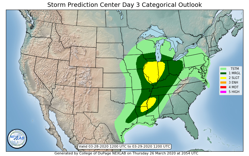
Beat me to it, just got home and seen that. I know better than to get my hopes up, but 3 straight days in a Mrgl or Slight. Still haven't heard thunder this year.
-
1
-
-
Have a solid coating- 1/2" here in KSPI
Pavement's actually coated

-
2
-
-
Snowing here
-
CPC still with a rather large severe area in the 8+ day range. SPC and WPC have nothing delineated in the 7-8 day range, SPC with predictability too low.
New thing for CPC? Usually the delineate the SPC and WPC areas of notez but now they are going out on their own beyond warmer/colder than average.
.thumb.png.c125c011647455029c18f7364705705a.png)
-
 1
1
-
-
Marginal risk for Thursdayfor a portion of the forum, CPC also has a pretty big area delineated just south of the region. Not yet in SPC range

-
 1
1
-
-
No thunder today, onto the next one.......
Can't let winter ending kill the pessimism


.png.6437c7c63480b083c0578e85f8be8b93.png)

March 26-28 Severe Threat
in Lakes/Ohio Valley
Posted
About 7 hours late but sun shining here in KSPI