Hvward
-
Posts
3,523 -
Joined
-
Last visited
Content Type
Profiles
Blogs
Forums
American Weather
Media Demo
Store
Gallery
Everything posted by Hvward
-
NAM 3km coming in much further south with that initial thump rain/snow line. This could drop a nice 1"-3" widespread before the switchover.
-
Agree whole heartedly with this. That last GFS gave Johnson City 3 more inches with the backside. It will for sure be under modeled.
-
I am ready. Got the generator, 3 loads of firewood, 2 weeks of food, Starlink, full propane tank. Ready to thrive and report.
-
Going to be in an interesting spot at my house at 2900’ in Black Mountain. I have no idea how we do in these type events since I havent experienced one here. Hoping we can hang on to the snow and get a couple of inches before the sleet. Worried about the freezing rain as well here.
-
I will be watching Northern Mississippi tonight to see if there are snow reports and what is falling. That will be where the tongue of precipitation comes from that could bring the early thump of snow. HRRR had a nice south jump the past few runs there.
-
18z GFS drops the snow line around 50 miles or so. Puts the NW mountains back in the snow game.
-
Yep came to post the same thing Met. With the Great Lakes connection and the very cold temps this is a good setup for NWFS. Kind of seeing a deformation feature developing on the backside, that could help as well. Nonetheless this is looking to be a solid 48 hour event that will have major impacts. I am hoping that the rain comes in Sunday afternoon and melts some ice that develops. That could be a big saving grace especially for the SW mountains. Tough forecast here for sure.
-
Nam3km has a smaller warm nose at hr 60 compared the NAM. I think we are going to have to rely on short range models to see if we get a few hours on Saturday of snow before the warm nose interferes.
-
No rest for the weary here. Hopefully everyone has power to track this next wave in the 10 day. All 3 major models show another shot. Of course take it with a grain of salt, but winter certainly doesn’t look over after the ice passes.
-
Thanks going to post a bit about this.
-
I have seen a 1036-1038 high get the job done here. A 1044 high makes me think the models aren't valuing it as much as they should.
-
It was give TN 4"-5" of snow 18 hours from this past weekends event. So was the Nam 3km.
-
Looks to me like a large difference between the two models is the tongue of moisture out ahead of the front that the GFS develops. It’s not really fighting the warm nose. Euro does not have that precip beginning Saturday AM. Still looks like a big mess right now, hopefully the low will trend a bit weaker and we can stay snow for a bit. I do believe most will start as snow, just a matter of how quickly precip arrives and how strong the low gets.
-
18z Euro cuts snow totals to basically zero and has all sleet for all of WNC through Sunday then shows a change to rain. Wow, we all know its possible though.
-
Probably the best GFS run I have ever seen for WNC. That was impressive and it starts precipitation late Friday night. 48 hour event.
-
Too hard to tell right now. It's all going to happen at the 700mb level. Warm nose comes in way up high and produces full melt, then it falls through 5000ft of frozen, hits the surface at 21 degrees as sleet because after full melt we have full freeze again. I am banking on sleet over freezing rain. Sounding screams full melt then full freeze again. General rule of thumb from what I learned was that you need around 1500' of above freezing temps for the parcel to fall through to produce full melt and the same is true with refreezing of precipitation.
-
6z Euro with another huge hit. This is starting to get a little worrisome honestly. We really don't need 12"+ of snow and ice on top of that, then temps close to zero. People need to get prepared, lots of power outages are going to occur.
-
6z Euro now showing a little appetizer on Friday AM. I would consider this a baroclinic leaf out of front of the main storm. Something to watch.
-
Its been since the 2017 and 2018 Dec storms that I can remember seeing models so robust for us.
-
6z GFS is scary for WNC. Power grid problems for sure if that comes to fruition. Almost a foot of snow before the low transfers and then a deformation feature behind it. Might have to start getting pretty serious on this one.
-
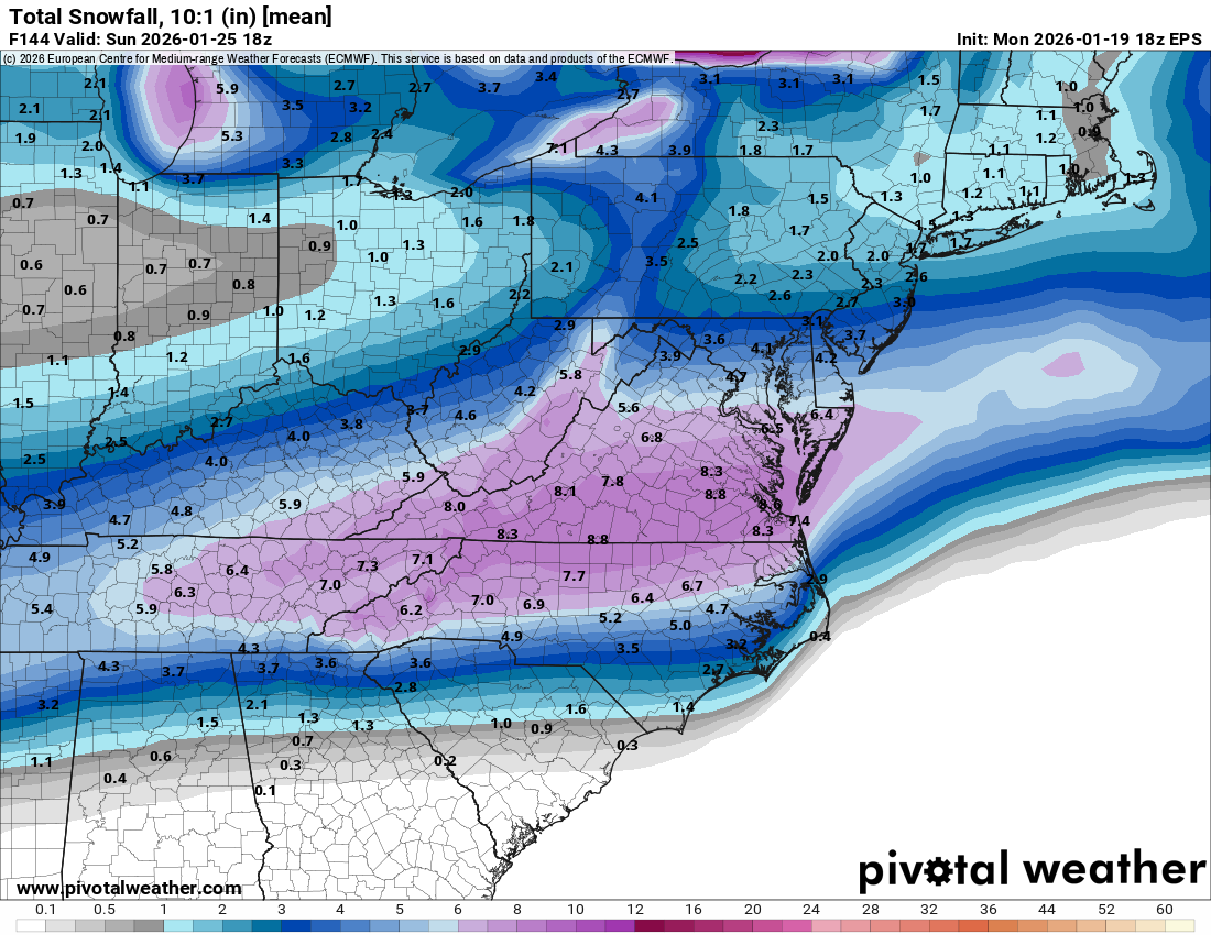
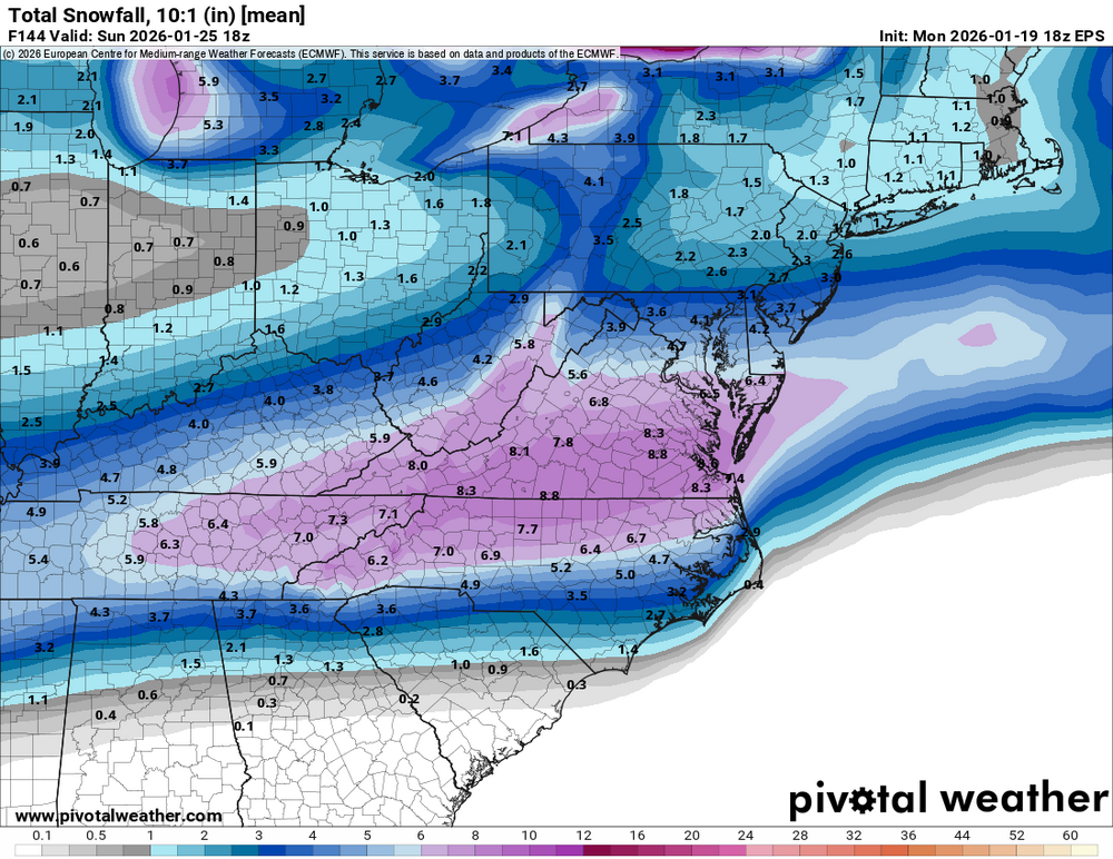
18z EPS has nearly the same totals as the 12z. Widespread 6"+.
-
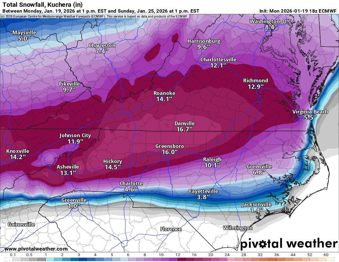
Crush job for most all of WNC on 18z Euro. Some mixing issues as you head SW, but showing mid teens at the surface. This is one powerful storm.

-
Big one coming in with the Euro. Showing an epic omega block.
-
18z Euro was a lot of ice through the end of the run but had the potential to switch over if it kept on going. Still has a massive storm.
-
Well we haven’t had an EPS run that looked this good in a while. I’ll roll the dice with this setup. Some big dogs in there as well. You can see there are some differing opinions on whether this will be 1 wave or 2.