buckeye
-
Posts
8,861 -
Joined
Content Type
Profiles
Blogs
Forums
American Weather
Media Demo
Store
Gallery
Everything posted by buckeye
-

Let’s talk winter!! Ohio and surrounding states!! 24'-25'
buckeye replied to buckeye's topic in Lakes/Ohio Valley
Yea I was trying to think of our last 10”+ snowstorm. 18 years, sheesh -
Let’s talk winter!! Ohio and surrounding states!! 24'-25'
buckeye replied to buckeye's topic in Lakes/Ohio Valley
Looks like last minute trends are slightly nudging the heavy axis a little more north. Seeing more outputs of 12” for cmh. Looking like our first legit big dog since? -
Let’s talk winter!! Ohio and surrounding states!! 24'-25'
buckeye replied to buckeye's topic in Lakes/Ohio Valley
so how's the ohio crowd feeling now that models have all held together for a widespread 8-12 incher across Central Ohio, 36 hours out? What if any changes do you think might happen between now and during the storm? For me, I have zero worries of mixing and actually wouldn't mind a little bit stronger push north. Biggest concern is the dry air pushing more than the models are forecasting and losing some inches with the initial overrunning because of that. I think what will be telling is how much of a virga storm we get Saturday afternoon/evening. I can see a scenario waking up early Sunday morning with pixie dust and a wispy dusting on the ground and everyone freaking out that it's a bust....even though the main slug comes in Sunday morning into evening with the low. If we can score big on the initial overrunning than it's definitely game on for 12". No matter what happens it's pretty much a sure bet we break that 6" seal...finally...and we actually get to keep it for awhile instead of the usual 2 days. -
1/24-1/25 Major Winter Storm - S. IL, IN, and OH
buckeye replied to A-L-E-K's topic in Lakes/Ohio Valley
say what you want, but he remains the consummate professional
-
1/24-1/25 Major Winter Storm - S. IL, IN, and OH
buckeye replied to A-L-E-K's topic in Lakes/Ohio Valley
he must have consulted with JB about what proper ratios to use -
Let’s talk winter!! Ohio and surrounding states!! 24'-25'
buckeye replied to buckeye's topic in Lakes/Ohio Valley
welcome back, this is like a reunion. I'm not ready to invest in this one until after the 00z runs...that leaves about 36 hours to start. I'm banking on the assumption that models have improved enough in the last 20 years that we don't have to worry about another real time catastrophic failure, ie Feb 2007. -
1/24-1/25 Major Winter Storm - S. IL, IN, and OH
buckeye replied to A-L-E-K's topic in Lakes/Ohio Valley
yea, the nam and the gfs are bookends and the euro is the book. Same old same old -
1/24-1/25 Major Winter Storm - S. IL, IN, and OH
buckeye replied to A-L-E-K's topic in Lakes/Ohio Valley
as much as I'd love that /\ this has more of a realistic feeling to it.
-
1/24-1/25 Major Winter Storm - S. IL, IN, and OH
buckeye replied to A-L-E-K's topic in Lakes/Ohio Valley
pretty solid consensus across the board, 7-9" along i-70. 6-10 seems like a solid forecast. Been awhile since we officially broke 6" in CMH so I ain't complaining -
1/24-1/25 Major Winter Storm - S. IL, IN, and OH
buckeye replied to A-L-E-K's topic in Lakes/Ohio Valley
actually small diff I noticed, (also on the rgem) is the ns is a bit more flat and slightly further south. It's squeezing the precip shield and creating a sharper cutoff to the north. Probably noise at this point but definitely any hope for a stronger, further north trend isn't there....at least not yet. Actually I'm rooting for nw stronger myself. In the meantime this is an ohio river valley beatdown! -
1/24-1/25 Major Winter Storm - S. IL, IN, and OH
buckeye replied to A-L-E-K's topic in Lakes/Ohio Valley
seemed low but only goes through Sunday 7am -
1/24-1/25 Major Winter Storm - S. IL, IN, and OH
buckeye replied to A-L-E-K's topic in Lakes/Ohio Valley
can't see what's going on along the MA.... but that looks like a wrist-slitter for those guys -
Let’s talk winter!! Ohio and surrounding states!! 24'-25'
buckeye replied to buckeye's topic in Lakes/Ohio Valley
long time no read my friend.... hopefully we can score this -
1/24-1/25 Major Winter Storm - S. IL, IN, and OH
buckeye replied to A-L-E-K's topic in Lakes/Ohio Valley
dude....cincy and towns along the ohio rive are ground zero for big snows west of the apps. If we get 6-10 you guys are easily 12+ -
1/24-1/25 Major Winter Storm - S. IL, IN, and OH
buckeye replied to A-L-E-K's topic in Lakes/Ohio Valley
Model consistency has really lined up. I like where we are along i70. We have some breathing room for a last minute nudge north, since the heaviest snow right now looks like southern Ohio along the river. Actually more worried about dry air and push south vs a big push north. ILN referenced the challenge of the initial push of moisture overcoming the dry air. Gotta wonder if we have hours of a virga storm to start.. -
1/24-1/25 Major Winter Storm - S. IL, IN, and OH
buckeye replied to A-L-E-K's topic in Lakes/Ohio Valley
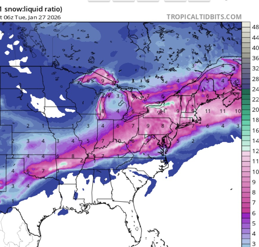
Temps are gonna be a story, not so much for extreme record lows, rather the duration of the cold. Flipping through the euro for mby, the period starting this Sunday til the end of it's run, (Feb 5), our highest temp is 20 degrees. Just as strange, the lowest temp is like -10 which granted is probably a record for whichever day it occurs, but it's not really that crazy considering the snowpack we should have throughout that time frame. Usually these cold waves that hit this time of year with a snow pack almost always have a few days with stupid cold that rival all time cold record, (Dec 1989 -18 and Jan 1994 -22). The other thing with these types of periods is when the back breaks with the pattern, it's usually done for the winter.... (old man winter blows his load, then shuts the lights and goes to bed) -
1/24-1/25 Major Winter Storm - S. IL, IN, and OH
buckeye replied to A-L-E-K's topic in Lakes/Ohio Valley
probably tomorrow those watches will expand to the east coast and up more through OH and IN meaning almost 1/4 of the US mainland will be under a winterstorm watch or warning.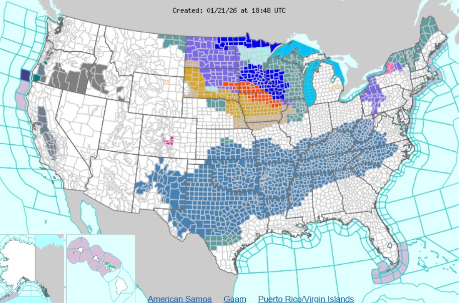
-
1/24-1/25 Major Winter Storm - S. IL, IN, and OH
buckeye replied to A-L-E-K's topic in Lakes/Ohio Valley
noticed that as well. Also the northern stream is a little faster too which keeps the trough more positively tilted and you don't get time for a solid phase and a stronger primary. Personally I wouldn't mind a 'tad' more phasing. I don't mind smelling sleet and I'll even eat a little sleet if it results in a widespread hit for our sub. -
1/24-1/25 Major Winter Storm - S. IL, IN, and OH
buckeye replied to A-L-E-K's topic in Lakes/Ohio Valley
I've never seen a snowstorm that buried Chicago-Detroit-DC. If Chicago picks up 9" from this, DC would probably be slop to rain -
1/24-1/25 Major Winter Storm - S. IL, IN, and OH
buckeye replied to A-L-E-K's topic in Lakes/Ohio Valley
GFS does it all over one week later.... except more of an app runner look -
1/24-1/25 Major Winter Storm - S. IL, IN, and OH
buckeye replied to A-L-E-K's topic in Lakes/Ohio Valley
always a possibility, but remember ... the winner is whoever gets closest to the mix line without going over. There is a caveat too, if mix plays in, it would come at the end of this and after one hell of an overrunning thump. Someone mentioned Jan 1999, that's what happened with that storm, we picked up 9" before it changed to drizzle, and that storm drove up well west of us, (I think the low went up into Indiana). -
Winter 2025-26 Medium/Long Range Discussion
buckeye replied to michsnowfreak's topic in Lakes/Ohio Valley
December 1989 was the last time I recall such widespread brutal cold across the whole conus. We hit -18 at the peak of that coldwave. When it broke, winter was over. -
Winter 2025-26 Medium/Long Range Discussion
buckeye replied to michsnowfreak's topic in Lakes/Ohio Valley
if the trend on that 18z euro continues with more and more of a big phase....Josh might be reeling this one in. -
Let’s talk winter!! Ohio and surrounding states!! 24'-25'
buckeye replied to buckeye's topic in Lakes/Ohio Valley
that only happens when we're in the bullseye....when the system is progged south of us there's no such thing as nw trend -
Let’s talk winter!! Ohio and surrounding states!! 24'-25'
buckeye replied to buckeye's topic in Lakes/Ohio Valley
Still about 4 days out from depicted start of snow. That's an eternity when you have to deal with a northern stream feature interacting with a sw feature and a pv. Really need that sw to phase in better with the ns dropping down, and we know how that always seems to go. Did notice that HP was weaker and further north as the system rolled east on the euro. That's really what 'saved' us, and offset the weaker phasing and allowed the precip to still come further north. No feeling in my gut on this one. I can absolutely see the phasing falling apart leading to a 12zgfs-esque solution. All it takes would be the ns to speed up and the sw to hang back....that seems to be a common scenario over the last several winters, (failed phasing with a quicker ns). Still, the option for something bigger is definitely on the table too, especially with the temps during the snowfall leading to high ratios. I think one fail option we can take off the table...wtod Either way, this type of system is fun to track on the modeling.