BullCityWx
-
Posts
8,924 -
Joined
-
Last visited
Content Type
Profiles
Blogs
Forums
American Weather
Media Demo
Store
Gallery
Everything posted by BullCityWx
-
So am I just imagining what it shows for Durham?
-
I get that it’s easy to be frustrated but the ICON clearly has the storm. It oscillated slightly but it’s still there.
-
Yes. I’ve experienced that before.
-
What?
-

-
That was well on its way to a significant ice storm by hour 84.
-
Amen to that.
-
Seems like we have decent enough agreement to start a thread.
-
I mean I sure dont but I have half an inch of ice accretion about 12 miles from my front door.
-
I think it looks just fine. There's a "cold rain" warning criteria ice storm this run for the triad and northern triangle. It's slightly less impressive than the GFS and ICON but it's still there.
-
Euro is trying to pull an ICON for Saturday.
-
Back down in the dumps again?
-
Roanoke to Farmville to the coast.
-
yeah, it's definitely not air-tight.
-
the 0z 850 degree has moved about 100 miles south today on the euro for Friday.
-
Okay, lets think about this. If the evolution of all of this happens like it might, there's going to be snow cover to just 50 miles N of the NC/VA border. How is that cold air going to moderate? If the evolution goes like we've seen and we get the damming high over NYS, it's a matter of ptype. Someone is going to get clocked with freezing rain and I still think the snow cover already here is going to push the thermal boundaries south. I could see this being a damming event that reaches Birmingham.
-
I figured this one would pull you out of the woodwork!
-
so if I'm looking at the GFS for MBY: .2 ice accretion on Friday .3 ice accretion on Saturday 3" snow on Tuesday with temps around 20. I dont know if it'll be right but wow.
-
This run is more realistic to what I think could happen with a high in that position and of that strength. Snow to sleet from GSP to RDU with freezing rain from Columbia to Greenville, NC.
-
Aint that the truth.
-
It could be lights out for people before Tuesday.
-
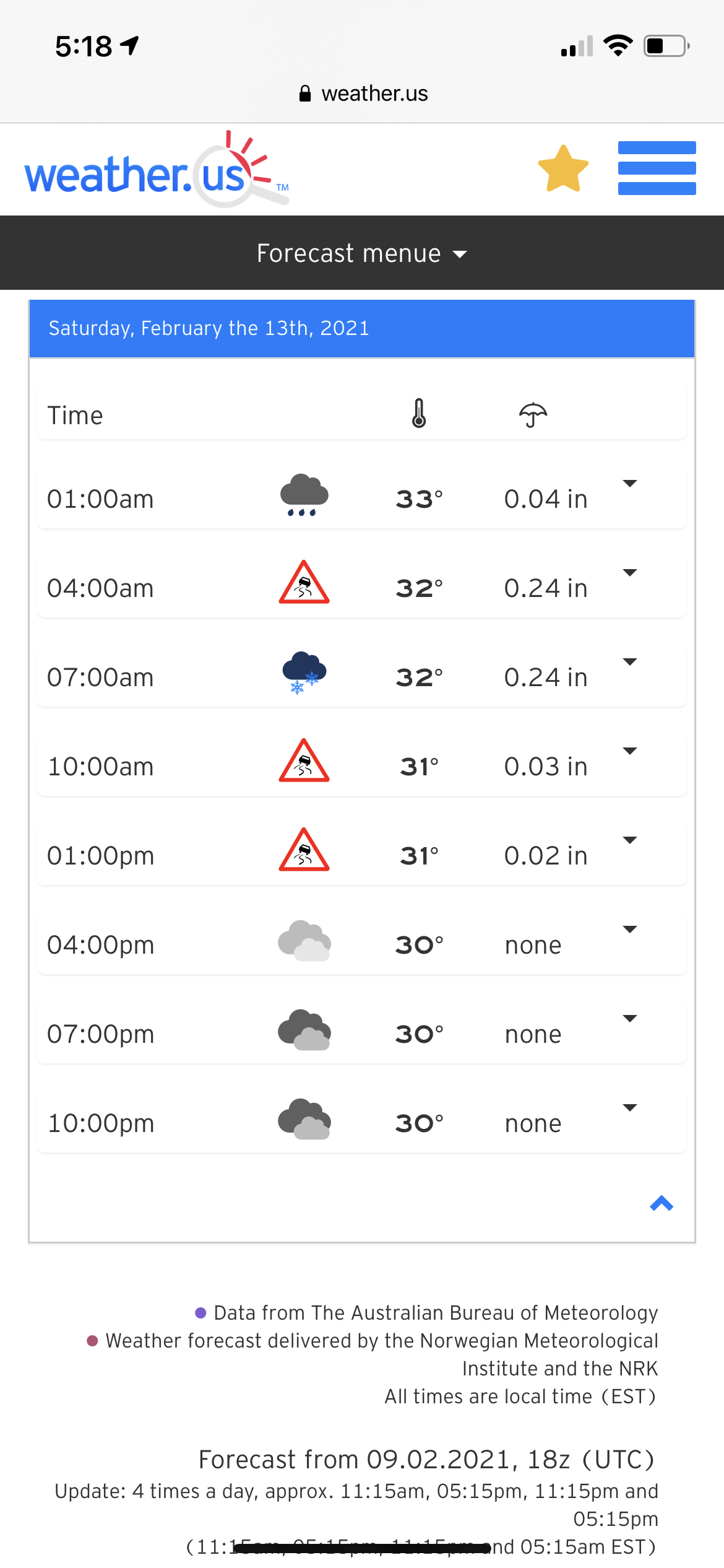
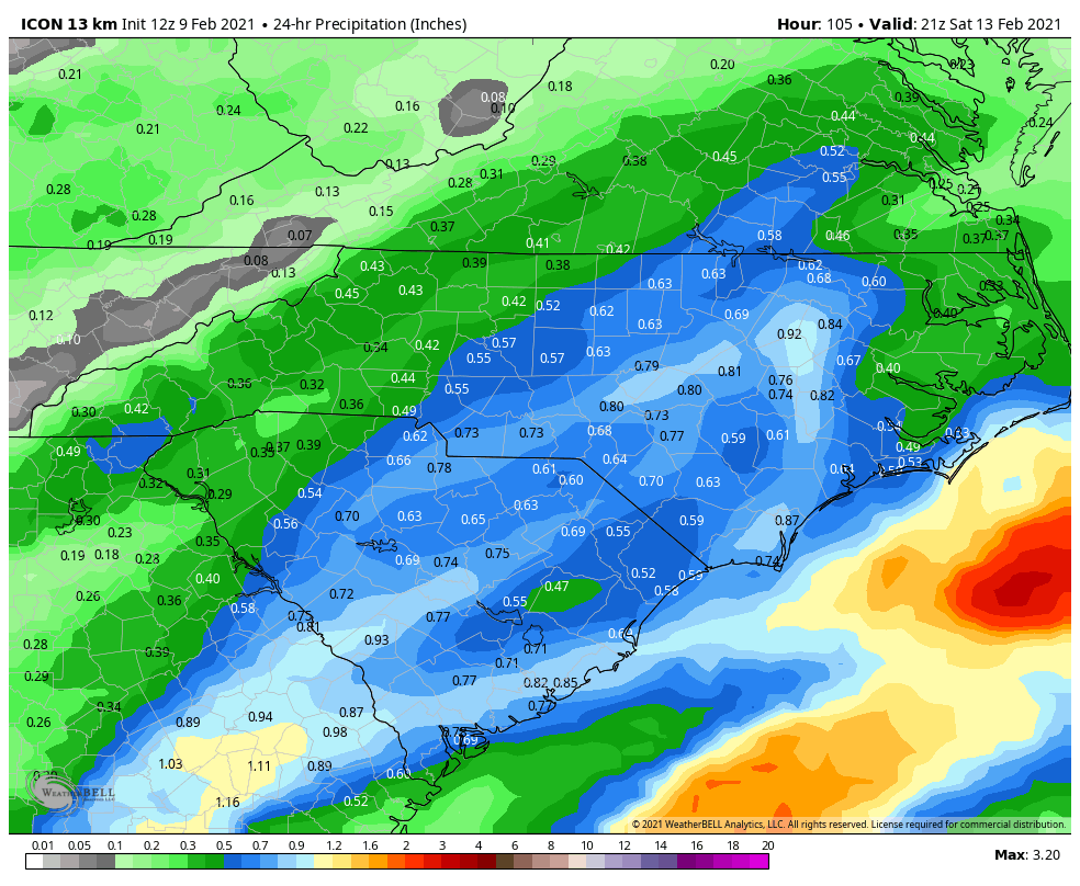
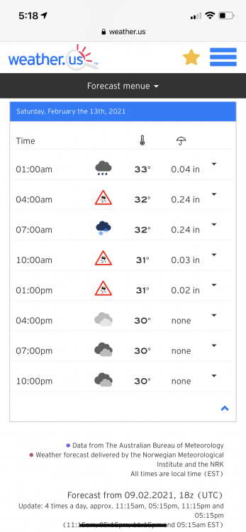
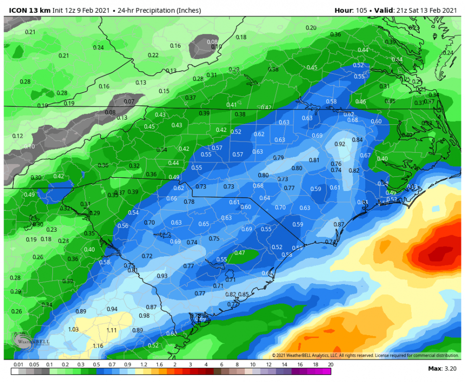
ICON has a warning criteria ice event on Saturday for RDU and CLT metros.
-
I would say for areas N&W of 85 in the triangle for sure, possibly further south.
-
It could definitely go that route. If you were going to ask me for a perfect scenario for a multi-day freezing drizzle event, this is pretty much it. Rare around these parts but so is the cold air
-
Yeah, it's really the perfect recipe for a multi-day freezing rain event.