BullCityWx
-
Posts
8,924 -
Joined
-
Last visited
Content Type
Profiles
Blogs
Forums
American Weather
Media Demo
Store
Gallery
Everything posted by BullCityWx
-

February 18-19 MAJOR Ice Storm Threat
BullCityWx replied to NorthHillsWx's topic in Southeastern States
We almost always have our thermostat at 65 in the winter. We’re warming up to 70 for this just in case. -
February 18-19 MAJOR Ice Storm Threat
BullCityWx replied to NorthHillsWx's topic in Southeastern States
Plan on it but don’t count on it. I’m 7 miles NW and it definitely looks suboptimal here given today’s trends. -
February 18-19 MAJOR Ice Storm Threat
BullCityWx replied to NorthHillsWx's topic in Southeastern States
Funny thing is, I think someone in the upstate got close to an inch that storm. -
February 18-19 MAJOR Ice Storm Threat
BullCityWx replied to NorthHillsWx's topic in Southeastern States
I HOPE YOU GET AN INCH OF ICE.- 970 replies
-
- 11
-

-

-
February 18-19 MAJOR Ice Storm Threat
BullCityWx replied to NorthHillsWx's topic in Southeastern States
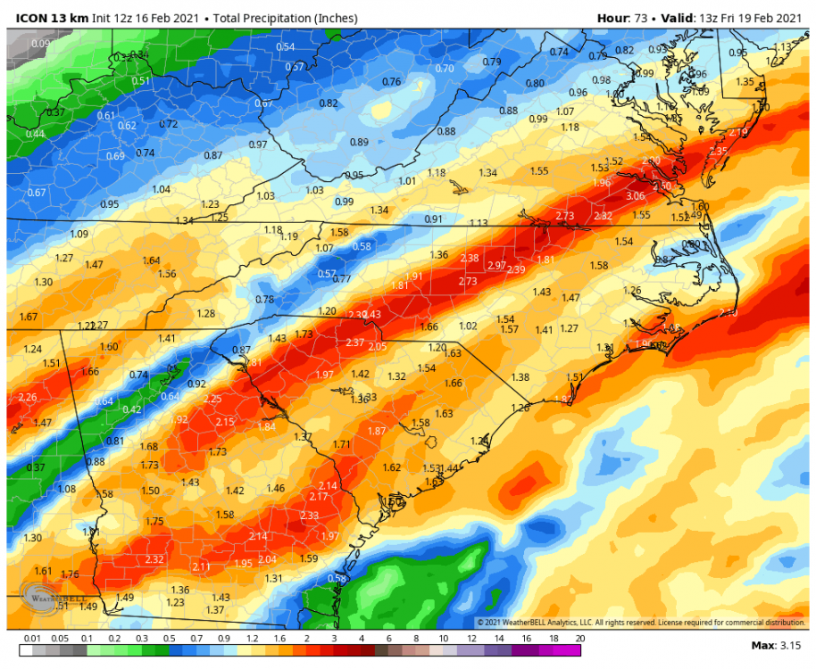
I mean if the RGEM or ICON is right, this is a generational ice event. -
February 18-19 MAJOR Ice Storm Threat
BullCityWx replied to NorthHillsWx's topic in Southeastern States
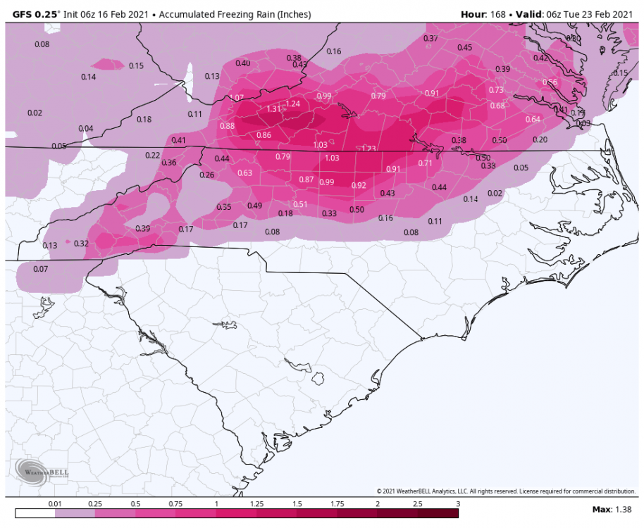
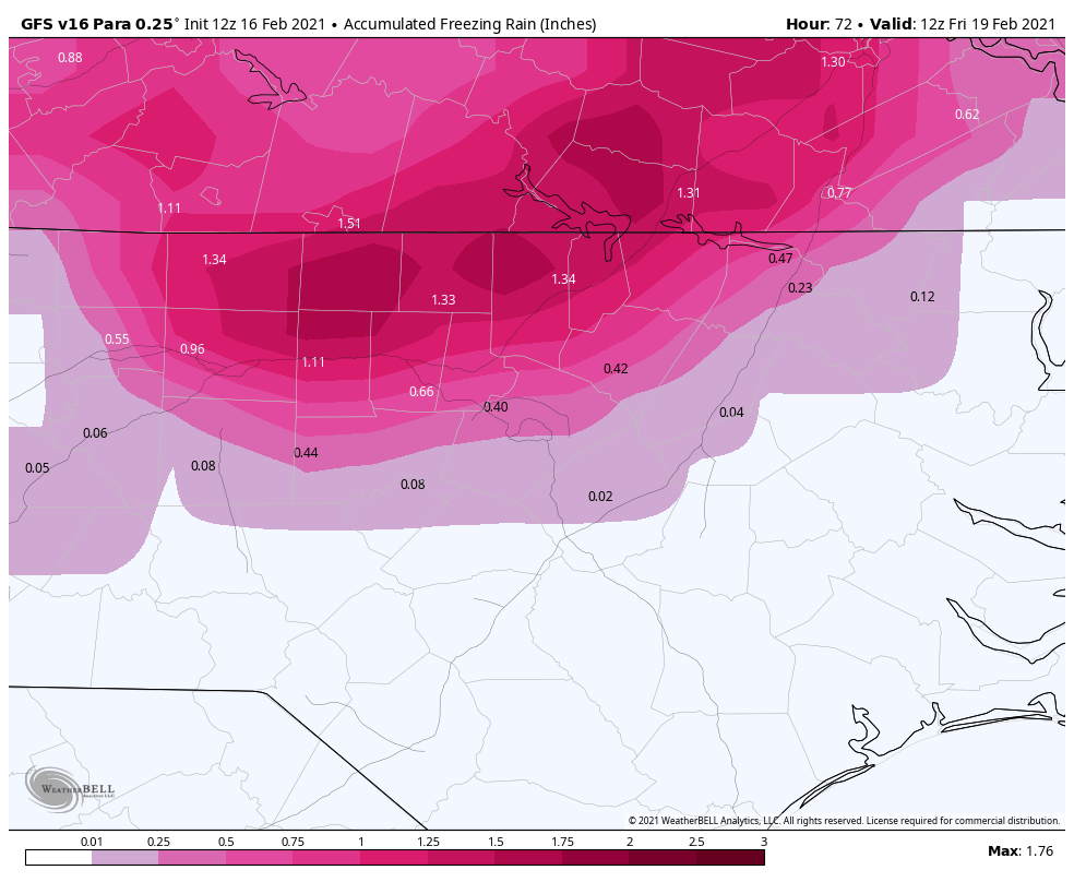
This has every bit the potential of being as bad as 2002, maybe worse because you won’t lose QPF to snow and sleet. -
February 18-19 MAJOR Ice Storm Threat
BullCityWx replied to NorthHillsWx's topic in Southeastern States
You’re right, the equivalent of a 384 hour GFS map. -
February 18-19 MAJOR Ice Storm Threat
BullCityWx replied to NorthHillsWx's topic in Southeastern States
.17 at the airport, probably warning criteria for 540N. Nothing more than a trace south and east of 40. -
February 18-19 MAJOR Ice Storm Threat
BullCityWx replied to NorthHillsWx's topic in Southeastern States
Euro drops the least amount of ice here and it's still basically double warning criteria. -
February 18-19 MAJOR Ice Storm Threat
BullCityWx replied to NorthHillsWx's topic in Southeastern States
This run of the euro pushes the ice down into the western suburbs of charlotte. -
February 18-19 MAJOR Ice Storm Threat
BullCityWx replied to NorthHillsWx's topic in Southeastern States
From the Canadian and my back yard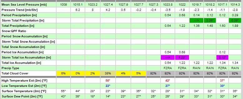
-
February 18-19 MAJOR Ice Storm Threat
BullCityWx replied to NorthHillsWx's topic in Southeastern States
-
February 18-19 MAJOR Ice Storm Threat
BullCityWx replied to NorthHillsWx's topic in Southeastern States
Totally agree. Unless we correct by 7-8 degrees most places, any sleet at all is totally off the table. -
February 18-19 MAJOR Ice Storm Threat
BullCityWx replied to NorthHillsWx's topic in Southeastern States
You should look into North Durham County. -
February 18-19 MAJOR Ice Storm Threat
BullCityWx replied to NorthHillsWx's topic in Southeastern States
The RDPS(think RGEM HRRR) is super cold at the surface. As cold or colder than the RGEM. -
February 18-19 MAJOR Ice Storm Threat
BullCityWx replied to NorthHillsWx's topic in Southeastern States

-
February 18-19 MAJOR Ice Storm Threat
BullCityWx replied to NorthHillsWx's topic in Southeastern States
and conversely, I assume our watch currently is for N of 40 in Durham maybe even N of 85. -
February 18-19 MAJOR Ice Storm Threat
BullCityWx replied to NorthHillsWx's topic in Southeastern States
"Well, maybe the para wont be as bad"
-
February 18-19 MAJOR Ice Storm Threat
BullCityWx replied to NorthHillsWx's topic in Southeastern States
NCZ008>010-023>025-170400- /O.EXA.KRAH.WS.A.0002.210218T0500Z-210219T0500Z/ Granville-Vance-Warren-Alamance-Orange-Durham- Including the cities of Oxford, Creedmoor, Henderson, Kittrell, Warrenton, Norlina, Burlington, Graham, Mebane, Hillsborough, Chapel Hill, Carrboro, Durham, and Rougemont 1046 AM EST Tue Feb 16 2021 ...WINTER STORM WATCH IN EFFECT FROM LATE WEDNESDAY NIGHT THROUGH THURSDAY EVENING... * WHAT...Significant icing possible. Total ice accumulations of one tenth to two tenths of an inch possible. * WHERE...Portions of central North Carolina. * WHEN...From late Wednesday night through Thursday evening. * IMPACTS...Power outages and tree damage are likely due to the ice. Travel could be nearly impossible. The hazardous conditions could impact the morning or evening commute. PRECAUTIONARY/PREPAREDNESS ACTIONS... Monitor the latest forecasts for updates on this situation. -
February 18-19 MAJOR Ice Storm Threat
BullCityWx replied to NorthHillsWx's topic in Southeastern States
Winter Storm watch expanded to now include everybody N&W of 40/85 and then after the split, N of 85. Nothing for Wake or Chatham or east. -
February 18-19 MAJOR Ice Storm Threat
BullCityWx replied to NorthHillsWx's topic in Southeastern States
ouch.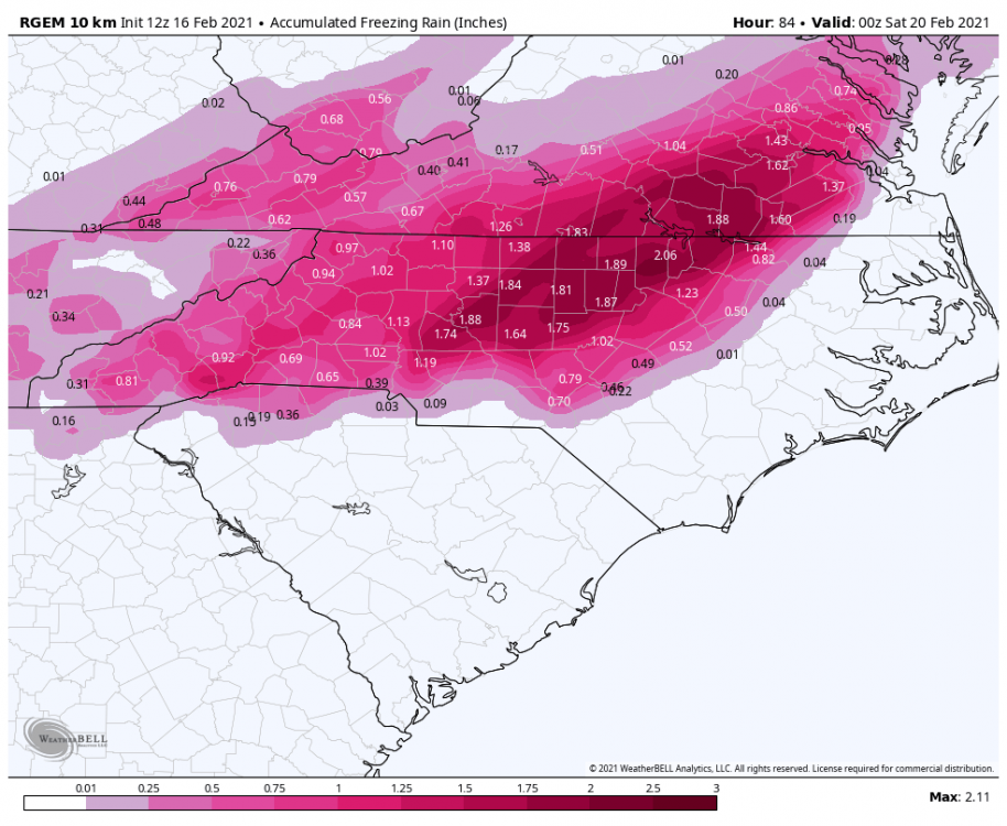
-
February 18-19 MAJOR Ice Storm Threat
BullCityWx replied to NorthHillsWx's topic in Southeastern States
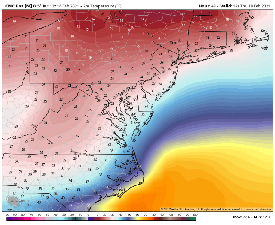
The weird thing is we are absolutely on fire at 850MB, despite the trends. We're talking about +11C at 850 on the NAM. The other models are much colder but it does give me pause to think about maintaining a freezing rain event with such a warm nose. 2002 never got warmer than +4C over the Charlotte area. -
February 18-19 MAJOR Ice Storm Threat
BullCityWx replied to NorthHillsWx's topic in Southeastern States
NBM has .3 totals for Caswell/Northern Orange/Far N Durham/Person counties. -
February 18-19 MAJOR Ice Storm Threat
BullCityWx replied to NorthHillsWx's topic in Southeastern States
NBM has me at .22 which is just short of a warning at 6z. At 12z, we're up to .27 which is warning criteria. -
February 18-19 MAJOR Ice Storm Threat
BullCityWx replied to NorthHillsWx's topic in Southeastern States