

Radtechwxman
-
Posts
2,477 -
Joined
-
Last visited
Content Type
Profiles
Blogs
Forums
American Weather
Media Demo
Store
Gallery
Everything posted by Radtechwxman
-

Pre-Christmas (Dec 21-23rd) Winter Storm
Radtechwxman replied to Chicago Storm's topic in Lakes/Ohio Valley
I'm not excited yet because there's too many moving pieces and a lot that can go wrong. Still worried gfs could be right with a further south and east track. Really won't know for a few more days till we get sampling of upper data and see how this 1st wave evolves Mon. -
Pre-Christmas (Dec 21-23rd) Winter Storm
Radtechwxman replied to Chicago Storm's topic in Lakes/Ohio Valley
You're not lying. Def trust hrrr more than nam. Really hoping euro has this one slam dunked. Gfs solution would just suck. Lol. So close yet so far away. -
Pre-Christmas (Dec 21-23rd) Winter Storm
Radtechwxman replied to Chicago Storm's topic in Lakes/Ohio Valley
That would be par for the course for here. Good ol central IL doughnut hole -
Pre-Christmas (Dec 21-23rd) Winter Storm
Radtechwxman replied to Chicago Storm's topic in Lakes/Ohio Valley
I see 18z gfs is continuing to gfs. I'm eager to see this in nam's range in a few days. -
Pre-Christmas (Dec 21-23rd) Winter Storm
Radtechwxman replied to Chicago Storm's topic in Lakes/Ohio Valley
It's called sarcasm but compared to euro it's like a dusting. Ha -
Pre-Christmas (Dec 21-23rd) Winter Storm
Radtechwxman replied to Chicago Storm's topic in Lakes/Ohio Valley
I'm sure they are having nuclear meltdowns like they often do. Lol. At least we can handle a miss and defeat even though it sucks. We watch them get nor'easters constantly. I remember same thing happened with GHD I. I think one model hung on to coastal storm while everything else was a GLC and they were fuming. -
Pre-Christmas (Dec 21-23rd) Winter Storm
Radtechwxman replied to Chicago Storm's topic in Lakes/Ohio Valley
And gfs the polar opposite, dusting for all. Lol -
Pre-Christmas (Dec 21-23rd) Winter Storm
Radtechwxman replied to Chicago Storm's topic in Lakes/Ohio Valley
Gfs still continues to be a stubborn mule but has a robust clipper come in behind the bigger storm on Xmas Eve -
Pre-Christmas (Dec 21-23rd) Winter Storm
Radtechwxman replied to Chicago Storm's topic in Lakes/Ohio Valley
If only we could lock that in now and this was only a few days out -
Pre-Christmas (Dec 21-23rd) Winter Storm
Radtechwxman replied to Chicago Storm's topic in Lakes/Ohio Valley
I'm still very happy with 0z euro compared to 12z run. Incredible bombing low albeit further ENE this run. Hoping an east trend won't commence with the cut. I like where it is. -
Pre-Christmas (Dec 21-23rd) Winter Storm
Radtechwxman replied to Chicago Storm's topic in Lakes/Ohio Valley
I wouldn't put much stock into any one solution right now esp the GFS -
Pre-Christmas (Dec 21-23rd) Winter Storm
Radtechwxman replied to Chicago Storm's topic in Lakes/Ohio Valley
I think we did but can't remember if it was gfs caving to euro or euro caving to gfs. Probably the latter -
Pre-Christmas (Dec 21-23rd) Winter Storm
Radtechwxman replied to Chicago Storm's topic in Lakes/Ohio Valley
I never knew that, thanks for that info. Definitely eager to see how this evolves over the coming days. I wonder if euro will hold firm or will cave to a gfs like solution with a coastal storm and only a glancing blow here from northern stream energy. -
Pre-Christmas (Dec 21-23rd) Winter Storm
Radtechwxman replied to Chicago Storm's topic in Lakes/Ohio Valley
Gfs being stubborn. Clipper like system to nor'easter transition. It's not wanting to do a GLC. Either it will be the lone model right or completely wrong. -
Pre-Christmas (Dec 21-23rd) Winter Storm
Radtechwxman replied to Chicago Storm's topic in Lakes/Ohio Valley
Funny b/c gfs was the model originally showing a GLC and really wound up sfc low for many runs and then it started bouncing all over the place. Now euro is the one showing this with some support from other global guidance. No way we will get something as extreme as 12z euro but even half that would be amazing. Gfs seems like it is baby stepping towards its original solution. Would like to see it cut more west and track a little more north than 18z showed. -
Winter 2022/23 Medium/Long Range Discussion
Radtechwxman replied to Chicago Storm's topic in Lakes/Ohio Valley
Lol 12z euro if only -
Winter 2022/23 Medium/Long Range Discussion
Radtechwxman replied to Chicago Storm's topic in Lakes/Ohio Valley
Right?! Wishcasting keeps the forum lively. Definitely eager to see how this pattern shift pans out. Would be a shame to see all this cold air go to waste but wouldn't be first time. Ha -
Winter 2022/23 Medium/Long Range Discussion
Radtechwxman replied to Chicago Storm's topic in Lakes/Ohio Valley
Not to get our hopes up for a good storm in long range or not get sucked in run to run on every model or both? Ha -
Winter 2022/23 Medium/Long Range Discussion
Radtechwxman replied to Chicago Storm's topic in Lakes/Ohio Valley
Yeah that 06z run of gfs was pretty depressing. Lol. A lot of cold and no snow. No thank you. Hopefully some kind of storm comes back on later runs. GFS has been fluctuating a lot. Honestly euro has as well. Man I want a white Xmas for a change. Plus I hate just cold and dry. Give me some snow! -
Winter 2022/23 Medium/Long Range Discussion
Radtechwxman replied to Chicago Storm's topic in Lakes/Ohio Valley
Man we can dream right? 0z euro is dream run but feel like a gfs like solution will end up being more plausible with some posdible advisory criteria snowfall with arctic front. A big storm would be nice but not getting my hopes up. GFS was showing something similar to euro before but hasn't had it for days now. Curious to see this in nam's range. -
11/29/22 MDT Outlook Issued -- Regional outbreak possible.
Radtechwxman replied to CryHavoc's topic in Central/Western States
Pretty much sounds like they will go high at some point. Parameters def support it. Storm mode is my main concern but like Quincy said, the hodos will support at least semi-discrete supercells even if shear vectors aren't completely perpendicular to initiating waa regime. -
11/29/22 MDT Outlook Issued -- Regional outbreak possible.
Radtechwxman replied to CryHavoc's topic in Central/Western States
14z hrrr is a potent run. Trio of long track supercells emerging out of ne LA into central MS with some intense, long helicity tracks. -
11/29/22 MDT Outlook Issued -- Regional outbreak possible.
Radtechwxman replied to CryHavoc's topic in Central/Western States
18z nam has a very concerning scenario and likely nocturnal tornado event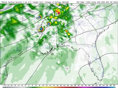
-
11/29/22 MDT Outlook Issued -- Regional outbreak possible.
Radtechwxman replied to CryHavoc's topic in Central/Western States
The sweet spot in the Delta -
11/29/22 MDT Outlook Issued -- Regional outbreak possible.
Radtechwxman replied to CryHavoc's topic in Central/Western States
This thread sure is dead for a enhanced risk in late Nov. This definitely has some synoptic similarities to Dec 10, 2021. Will it be of that caliber? Probably not. But definitely bears watching.


