

cyclone77
-
Posts
18,722 -
Joined
-
Last visited
Content Type
Profiles
Blogs
Forums
American Weather
Media Demo
Store
Gallery
Everything posted by cyclone77
-
Temp here has shot up to 54 degrees courtesy of humid southeast winds. You wouldn't know blizzard conditions were in the offing in less than 12 hours.
-
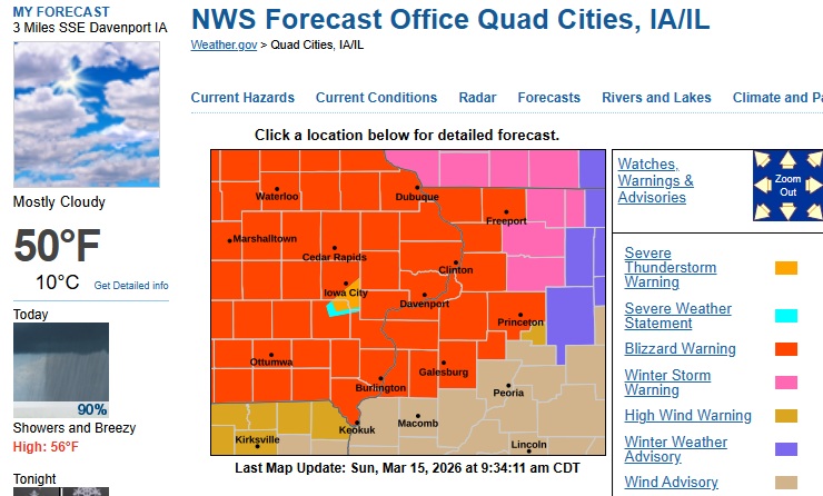
The infamous severe thunderstorm warning box within a blizzard warning.
- 716 replies
-
- 13
-

-

-
They're still acclimating to daylight savings changeover.
-
I will say, it's kind of fun having them be our office. I appreciate their excitement in interesting weather. I'd rather have that then an office that low-balls everything, and writes unmotivateed/lazy AFDs.
-
Des Moines office went with a blizzard warning, so pretty much guarantee DVN will excitedly join the party. Keep in mind they were the office who issued a widespread blizzard warning for scattered brief snow squalls earlier this winter where 90% of the warning didn't even see a flake.
-
First call for here/QC 0.2-1.2" of snow after a quick hitting non-severe squall line.
-
DVN office...
-
I expect all of my downspouts to be gone when I get home later.
-
The RGEM continues to rock us pretty good. If it wins out I may have to swap the American flag out front for a maple leaf lol.
-
Yep.
-
It's the RGEM, but verbatim it would have us going from a severe threat to heavy snow in 6hrs Sunday evening. If that in fact were to happen I'd change the winter grade from an F+ to an A+. Would completely make up for the past 3 months.
-
Haha yeah I think it is. I had already forgot about that lol.
-
I used to love chasing back in the day, and did a decent amount of it. I've completely lost interest in it over the past several years, just too many damn people out chasing now. Takes all the fun out of it for me. Maybe it's because I'm getting older and less aggressive? Not sure, but I enjoy just watching it all unfold from home these days lol.
-
RE GFS 12z, lock it in!
-
Wonder what the speed of an 8" stone would fall at? I remember reading that baseballs fall at well over 100mph so can't imagine what the 6-8" mph would be.
-
Looking good for you guys north and east. Any delay in the bombing will likely bump us out too far west, which will likely happen lol.
-
Picked up an additional 0.02" today. Brings the 2-day total up to 0.03" and a T of snow.
-
Hoping for a few showers.
-
I must be getting old enough to not know the new/kewl acronyms. What does TTH stand for? Talk to the hand? Guess that'd be TTTH. EDIT: nm, answered above.
-
Yeah had a few large wet flakes mix in here too under a brief bright band. Changed back to very light rain shortly after. Still top 3 event in past 2 months.
-
Gotta love it.

-
Everything's gone all around us this evening. Fine with me, don't want any hail damage lol. EDIT: Finished with 0.01" of rain for the day.
-
Looks like it was correct.
-
Cell north of Burlington Iowa is getting it's act together very quickly.
-
Was forecast to be near 70 but the back door cool front co ck blocked temp potential, and only made it to 56.


