

cyclone77
-
Posts
18,218 -
Joined
-
Last visited
Content Type
Profiles
Blogs
Forums
American Weather
Media Demo
Store
Gallery
Everything posted by cyclone77
-
Looking like 4+ inches of rain on the way over the next 10 days or so. May end up pushing double digit monthly rainfall totals for June if the pattern persists through late month. I'll be out in the pacific northwest all next week, so you can count on some quality storm action around here then lol.
-
91 here today
-
Spent much of the day with dews in the 40s. With the cornfields already at knee high we probably won't be seeing dews this low again until September.
-
Picked up 0.02" from some late afternoon post-frontal light rain. Up to 1.83" for the month now.
-
So far DVN has confirmed 8 tornadoes from last night. Also, SPC had issued severe watch instead of a tornado watch.
-
Snakeless as well lol
-
Another 0.60" overnight brings the total up to 1.80". Still quite a few people in the IL portion of the QC without power early this morning.
-
Was tornado warned here but weak rotation passed northwest of here on a weakening trend. Did get a nice period of 50mph winds and near zero visibility in absolute car wash style deluge. Up to 0.85" for the day but guessing a good amount of rain blew across the rain funnel during the storm. EDIT: Also, lol at SPC bumping us out of the slight after days of being in it, only to add it back late in the day. EDIT2: Finished with 1.20".
-
Damn. That's over 100 degrees according to my calculations.
-
46 this morning here. This is the kind of day when you go out fishing early in the morning you need a hoodie/pants, and by 10am u switch to shorts/t-shirt.
-
When do the locusts show up?
-
Canada needs to change their flag from this, to this


-

Spring 2025 Medium/Long Range Discussion
cyclone77 replied to Chicago Storm's topic in Lakes/Ohio Valley
Ready 2 b drowned -
0.38" so far with some rain still coming down. Enough to get us over 3" for the month now.
-
Bring on the ring of fire. This pattern's boring.
-
Another 0.30" today brings us to 2.20" for the 3-day total. Only made it to 54 this afternoon under the heavy overcast. Hard to believe we hit 95 6 days ago.
-
1.90" since yesterday. We definitely needed it.
-
Well timed soaker tonight/tomorrow and then kind of lame again for the next 10+ days. Hopefully June brings some real action.
-
Yeah it feels like we flipped the calendar back a few pages to be sure. Pretty brisk out there this morning.
-
Spring 2025 Medium/Long Range Discussion
cyclone77 replied to Chicago Storm's topic in Lakes/Ohio Valley

-
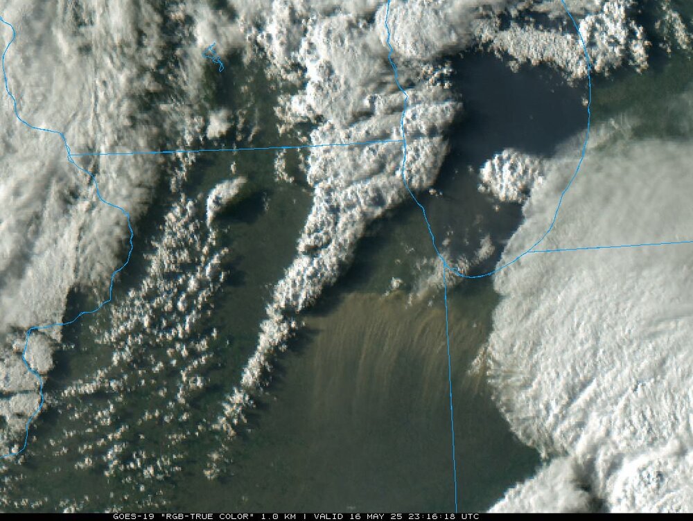
Very impressive dust storm. Shows up well on satellite.
-
I always wanted to know what it would be like at the top of Mt Washington. Luckily these winds the past several months have shown me a shining example of it.
-
Finally some decent rains may be on the way for next week if trends persist. After a lush first 2/3 of April it has become pretty dry/dusty around here the last few weeks.
-
High was 95 here, MLI a new record with 93, and DVN hit 94. Picked up a quick 0.05" as dry line cells pushed through. EDIT: Dewpoint at DVN has fallen back to 43 after hitting 70 earlier. Potent dryline.
-
Continuous thunder with this cell coming in from the southwest. Building quickly.


