

cyclone77
-
Posts
17,669 -
Joined
-
Last visited
Content Type
Profiles
Blogs
Forums
American Weather
Media Demo
Store
Gallery
Posts posted by cyclone77
-
-
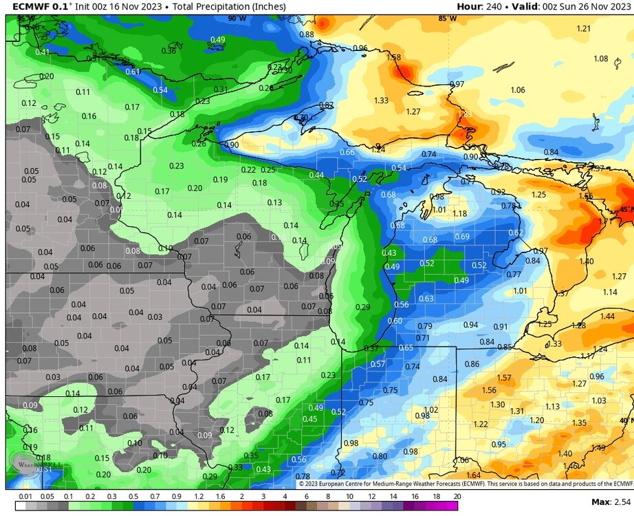
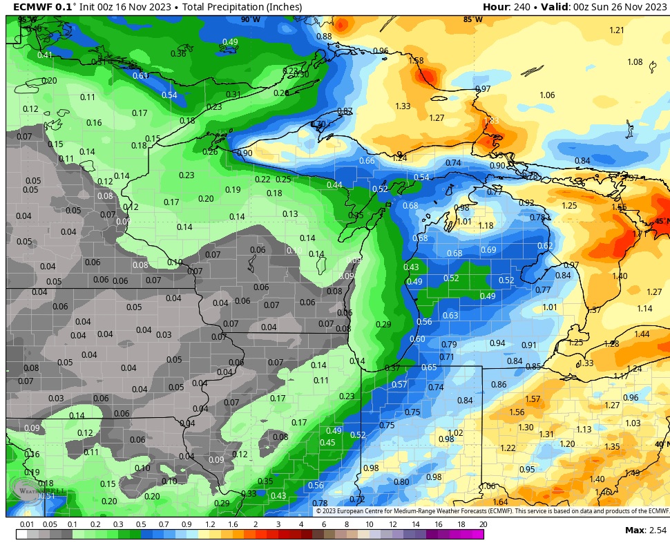
Digging the little upticks in overall QPF the last 24+hrs with this system. Hoping that's a good sign for the new season.
Models generally spit out around 0.2-0.25" for the QCA, so a nice 2" snowfall is what's expected.
-
 5
5
-
-
8 hours ago, SchaumburgStormer said:
The “storm” Saturday night into Sunday looks a bit juicier than I was expecting. With nowhere to go this weekend will be nice to see some flakes.
Yeah nice little event to kick off the new season.
-
Happy Thanksgiving everyone!
I ain't eating again till Tuesday lol
-
2
-
 1
1
-
-
Picked up 0.14" of rain over the past 6 hours. Top 2 event for November. Up to 0.35" for the month now.
EDIT: Finished with 0.40"
-
 1
1
-
-
Last warmish day for awhile today. Should make it to near 60. Perfect day for the last round of leaf/yard cleanup for '23.
A little light rain late Monday/Monday night but other than that it looks very quiet. A few wussy snow systems have fleetingly shown up at times next weekend and the week after, but doesn't look like anything to get too excited about. Hopefully things get more active in December.
-
2
-
-
All the trees around here are bare, even the oaks are mostly bare now.
-
Seems like clippers have been MIA for many seasons now. Seems like it at least out here in the western sub.
-
2
-
-
Might finish Nov with <0.30" precip here. Very dry this month which is good for the last minute farming.
-
28 minutes ago, RogueWaves said:
12z Euro trying to make the holiday week much less boring in the wx dept
.gif.696b373e388ee9c20d30735d1d667c22.gif)
For the eastern sub.
-
-
17 minutes ago, bowtie` said:
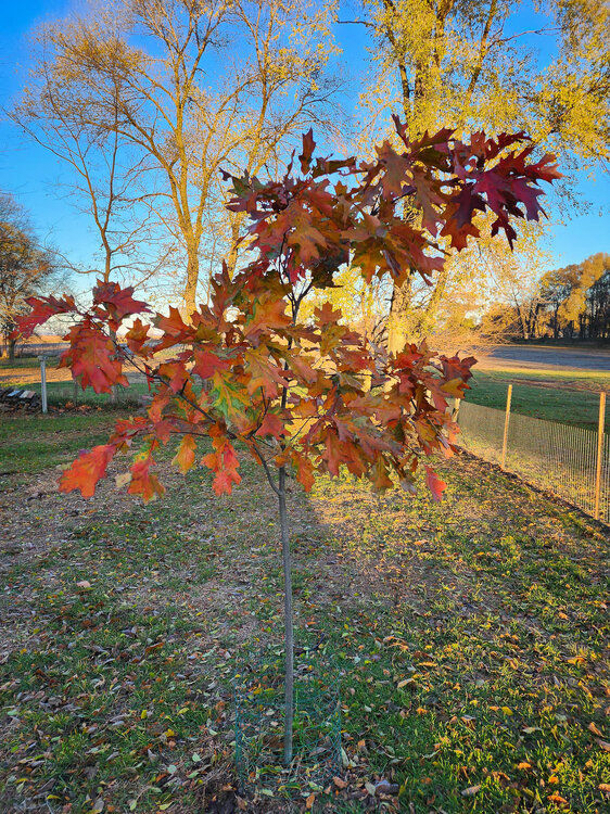
I love it when little tiny trees show some spunk.
Hopefully it'll still be around a few hundred years from now with a 4ft diameter trunk.

-
1
-
-
No palms here, but the little northern red oak is showing sugar maple-like colors this year.
-
7
-
-
Picked up 0.21" rain late this afternoon.
Most trees in this area are bare now other than the oaks which are near peak.
-
Maybe we'll roast through November and freeze our asses off in December. Last year's pre-xmas arctic blast was something to behold. Maybe we'll get another one of those.
")
-
3
-
-
Sure glad the models are coming out an hour earlier now. Especially since there's so much action to track.

-
2
-
6
-
-
Looks like a good shot at another 70 or two later next week.
-
1
-
-
Super hard freeze this morning with 19 so far. Welcome to November.
-
3
-
-
Several nice snow showers rolled through throughout the day. Some briefly skifted the ground with graupel. Really felt like winter out there today with the flakes flying and the 40mph winds.

-
2
-
-
First hard freeze here with 25 early this morning. First flakes on the way for tomorrow.
-
Humorous how the point forecast for here Tuesday goes back and forth between snow showers on one shift, or partly sunny on the next, as the forecasters disagree. Some are riding the GFS, and others give more credence to the Euro/RGEM. Think it's pretty stupid to not have any POPS though given the potent vort and even the near miss of the GFS would still likely warrant a POP. The forecasters who are leaving it bone dry are going to bomb.
-
A ton of leaves came down with the gusty post-frontal winds today. Many trees nearing bare now. Looking more and more like winter.
-
1
-
-
66/62 atm here with a muggy feel to the air. Cold front just passed through DVN, so have about a half hour left of this recent warm/humid spell.
Some models show a few wet flakes here as early as Sunday with the passing frontal wave. Best shot looks Tuesday though as that potent vort slams through the area.
-
1
-
-
Nice little soaker overnight/early this morning with 0.66". Should make a run at 6" for the month later today or this weekend.
-
3
-
-
Euro says trick or treaters will be greeted with snow showers Tuesday evening around this area.
-
1
-

Drought 2023
in Lakes/Ohio Valley
Posted
Must be making up for 2008 lol.
Didn't realize southeast IA was that dry, wow.