

nwohweather
-
Posts
3,552 -
Joined
-
Last visited
Content Type
Profiles
Blogs
Forums
American Weather
Media Demo
Store
Gallery
Posts posted by nwohweather
-
-
18 minutes ago, SolidIcewx said:
NASA Rocket Fuel
Or nitromethane if you’ve ever seen an NHRA race
-
26 minutes ago, Stebo said:
What if I wanted the tree down

Haha if you bought a new chainsaw I guess it’s worth it
-
Everyone needs to calm down, downed trees in the yard aren’t fun anyways
-
 2
2
-
-
39 minutes ago, nwohweather said:
Man the atmosphere is really recovering quickly. Ample shear & helicity to the east of current warnings in SE MI, lets just see if we can continue to build up. My house is currently at 75 degrees with a dewpoint of 75.
I just think it needed about 2 more hours. It's a shame we couldn't get that overlap better timed with the ingredients
-
54 minutes ago, Lightning said:
Nearly every system has found a way to put red+ blobs on radar right on Grand Rapids area As I type this Grand Rapids is getting hammered again. I am not sure you will be happy unless your house has been leveled by a EF5.
Ha, you act like they'll allow an EF5 rating anymore
-
 2
2
-
-
Man the atmosphere is really recovering quickly. Ample shear & helicity to the east of current warnings in SE MI, lets just see if we can continue to build up. My house is currently at 75 degrees with a dewpoint of 75.
-
A lot of downed trees around Toledo, definitely delivered with widespread damaging winds. That line looks legit hitting the Lake Erie Islands right now, 70 mph is probable over there
-
Definitely some spin up potential here

-
 2
2
-
-
Nice line approaching at the moment. Will be interesting to see what transpires as the instability is quite a bit higher over SE MI/NW OH, but it's outrunning the better shear a bit
-
30 minutes ago, Chinook said:
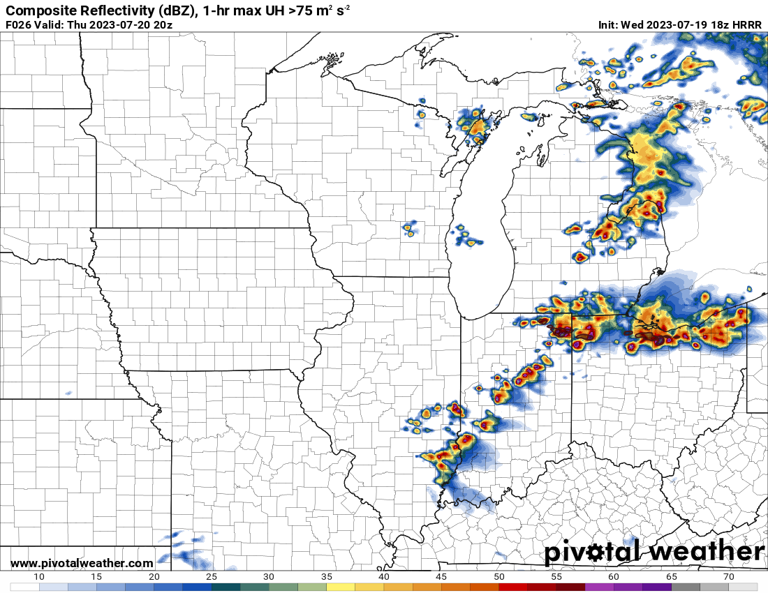
The 18z HRRR shows the overnight MCS system in Wisconsin that quickly advances to being a bow echo in mid-Michigan. Basically it says the rain misses OH/IN. It says the big stuff goes from the west side of Saginaw County to about the east side of Tuscola County in just 1 hour.
Hell of a bow echo there. Definitely the M-10 special right there
-
1
-
-
I figured I’d get this rolling with a Day 2 Enhanced. Definitely some solid chances tomorrow evening
-
Looking spicy tomorrow
-
1
-
-
2 hours ago, A-L-E-K said:
lush

Call it the splashpad instead of the Windy City
-
Some pop ups again
-
1 hour ago, HillsdaleMIWeather said:
Jinxed me lol, the storm moving into my county imploded
I was shocked. I know large-scale ascent is better towards Ontario but dang with the ingredients in place I'm a bit shocked
-
Canada is getting absolutely smoked at the moment. Rough time to be on the 401
-
1
-
-
1 minute ago, IWXwx said:
Golf balls are all that have been reported so far, but wouldn't doubt that there are some bigger stones
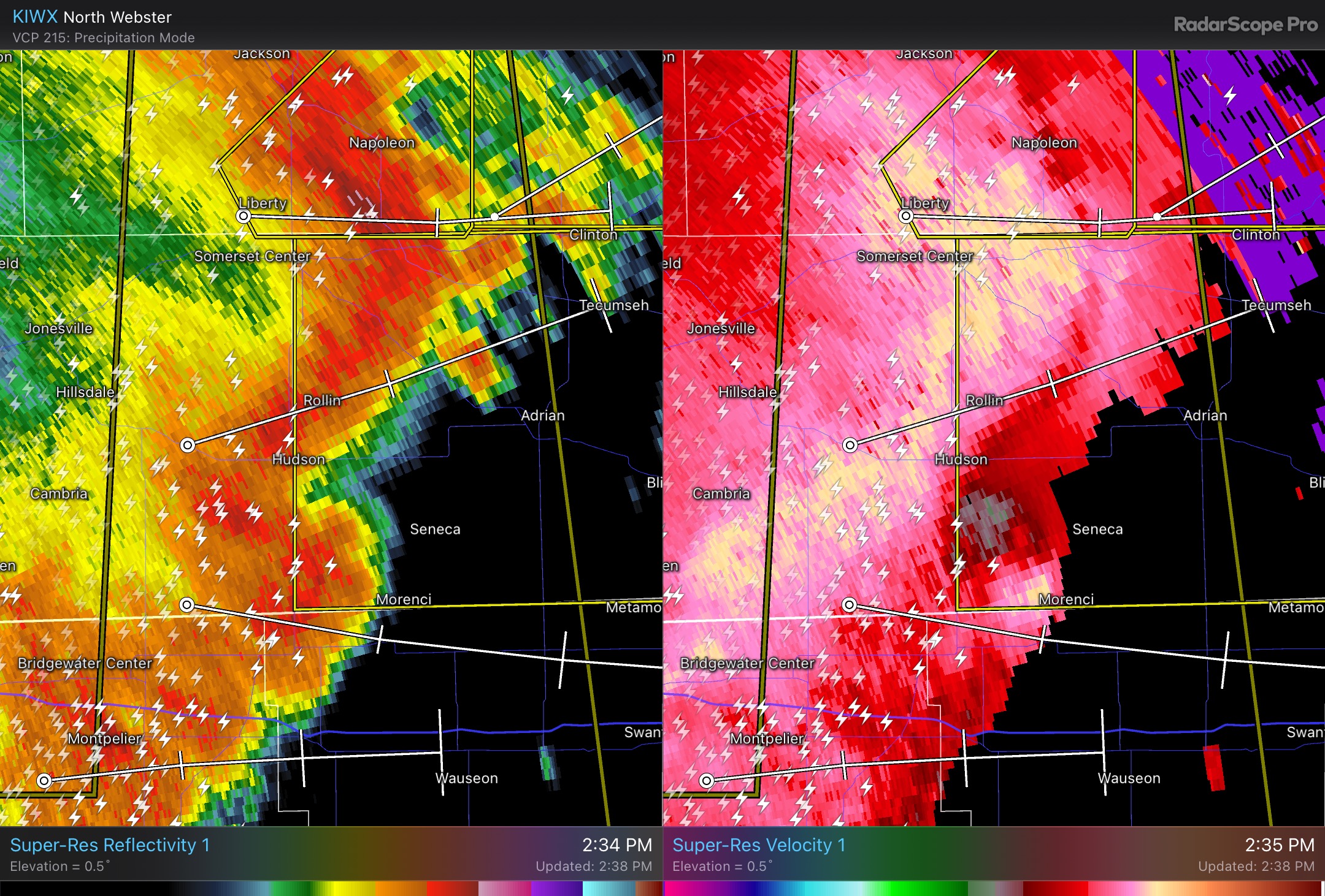
Really watching these storms as they approach Ohio. It seems the best environment is Coldwater to Fort Wayne & Findlay to Toledo. Anything in that square is pretty darn primed at the moment, seeing LI's around -8 and even -9 with LL lapse rates at 8° C/KM. Shear is solid but helicity is pretty low, a little higher around Hillsdale & Lenawee Counties so maybe something could spin up around there if it's discrete.
-
We probably have some tennis ball sized hail right now on that storm in between South Bend & Elkhart
-
8 minutes ago, SolidIcewx said:
You can really feel it today. Air is thicker than a campbells chunky soup
On a side note to this, as someone who lived in Charleston, SC for 3 years it's amazing how so many people want to relocate & go through this for 4 months a year. And we're only in the low 80's, heck right now my old house is at 94/74 with a projected high of 98 today. Outdoor activities were just brutal outside of swimming, and even then the pool this time of year would often be around 90 degrees
-
Certainly not lacking any energy. Still a small amount of capping in place but sheesh once that match gets thrown on the pile...

-
Love the hail chances today for here. Hard to imagine with those robust updrafts we won't see tornadoes here today, all definitely of the EF2 and under variety though. Planning to chase today for sure
-
9 hours ago, Chinook said:
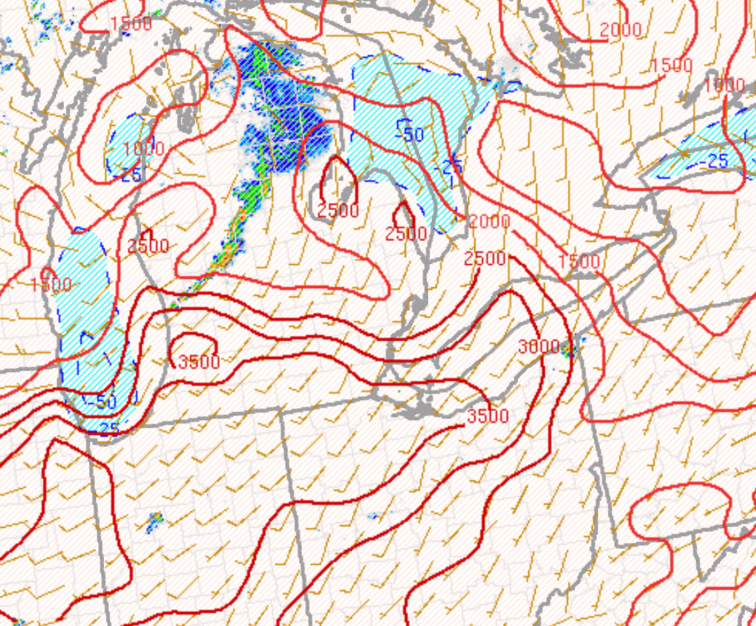
Things could get stormy tomorrow. Today's 12km NAM had 3900 J/kg of CAPE in NW Ohio. The models seem to vary on the 0-6km shear of 30kt up to 45 kt (the 18z NAM), which is quite good for summer, but storm relative helicity should not be remarkable. 12km NAM has up to 73 dew points in Indiana.
.thumb.png.df63eb7c209fa9492405088894db7a9b.png)

Not a bad setup. Concerned a bit with the LCL but I think we could see some solid hail and damaging winds tomorrow. I’d expect a tornado warning somewhere around Toledo with that front hanging out, you just know something will spin along it
-
East of I69 looks to be the hotspot especially just across the border. I’m hoping for some good ones to roll through. If supercells do form I’m going to go out. Right in the heart of it where I’m staying
Yeah it’s why going to Napoleon and sitting is a great move. Head west or east on 24 to chase -
Bit on the fringe of the subforum but Western Kentucky absolutely got destroyed with rain today including Mayfield.
Those quasi stationary boundaries can just be flat out deadly in these events. If I’m not mistaken something similar occurred in WV last year
.png.5eb3e539d50b9e233eacccf1a697b9d0.png)
July 28th Severe Weather
in Lakes/Ohio Valley
Posted
Quasi stationary boundaries man. As good of a rain producer as those buckets at water parks