

nwohweather
-
Posts
3,547 -
Joined
-
Last visited
Content Type
Profiles
Blogs
Forums
American Weather
Media Demo
Store
Gallery
Posts posted by nwohweather
-
-
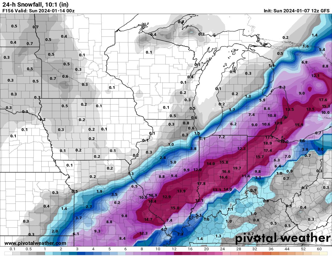
Barometer at home officially at 28.90. Can’t say I’ve seen it this low much in my life
-
9 minutes ago, Stevo6899 said:
Even sexier on the rgem, however it was SE with this current storm at this range so who knows at this point. Ukie/euro way nw.
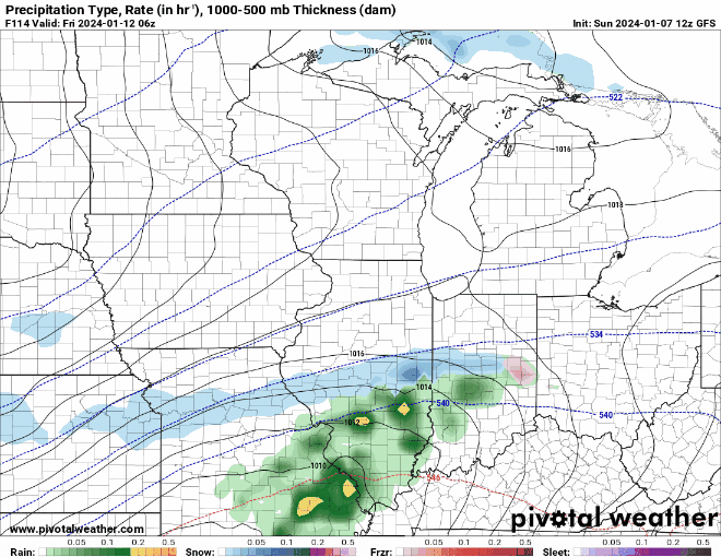
Also the deformation snows look to be very tight and close to the low which hopefully will keep the dry slot away, that the euro/ukie show.
So often you see the heaviest snows trend more towards the IN border counties west of I-75. We will see here but with mixing it wouldn’t shock me to see Toledo proper shafted a bit
-
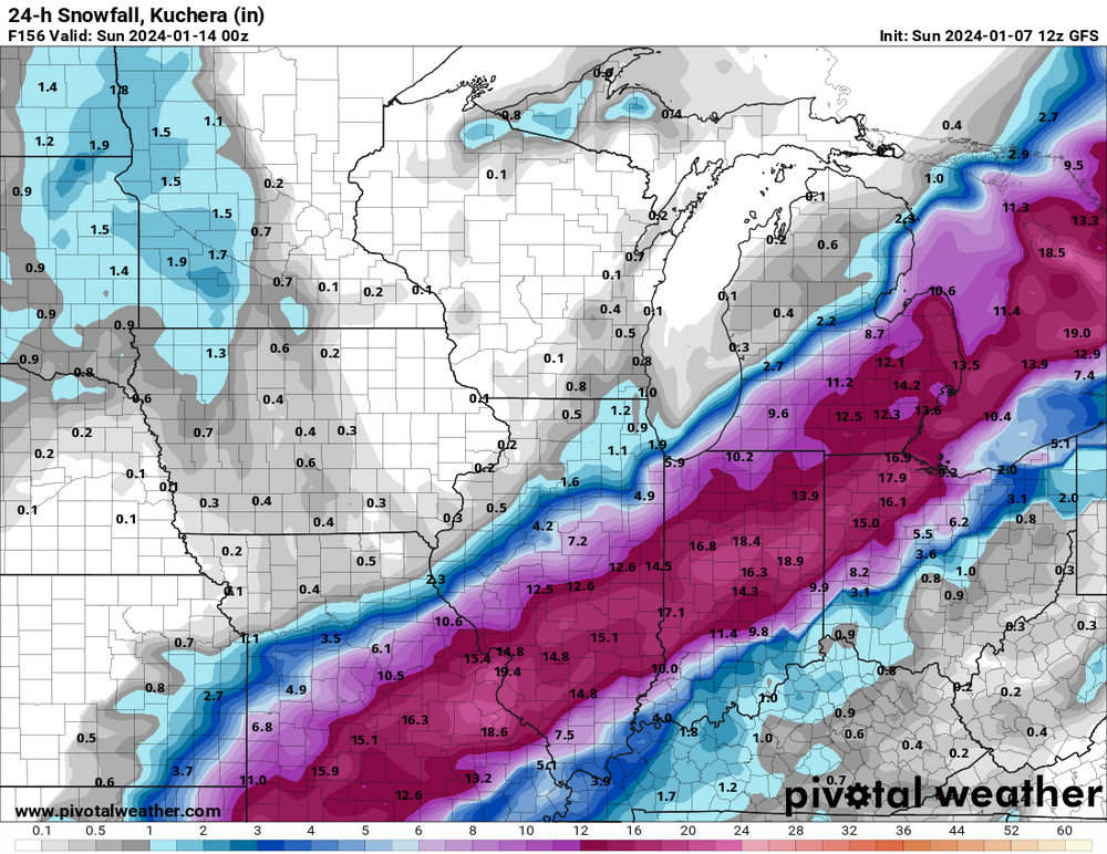
Hell of a storm for Toledo on deck, one of the best I've ever seen if it pans out on the GFS.
-
 2
2
-
-
A little out of area, but a PDS Severe T-Storm Warning is in effect for Charleston, SC due to 70-80 MPH winds. A string of warnings in effect from Richmond, VA to Tampa, FL. Just a truly dynamic storm system on display here in the CONUS today
-
 1
1
-
-
1 hour ago, BigHoss48192 said:
Another year...and probably another season of busted storms for SE Michigan. It's 34-35 out and not even raining but the radar shows that it's snowing outside. Must be evaporating before it even hits the ground. Nothing to see here....
Huh? I’m south of Toledo and it’s ripping snow!
On a side note, there is a hell of a hook on a supercell just NE of PCB. At the moment SRH values in AL/FL are between 400-800. Going to be a hell of a weather day in the US today
-
5 hours ago, RCNYILWX said:
Goes without saying but a really high end solution from the Euro. Powder keg of a setup if things break right.
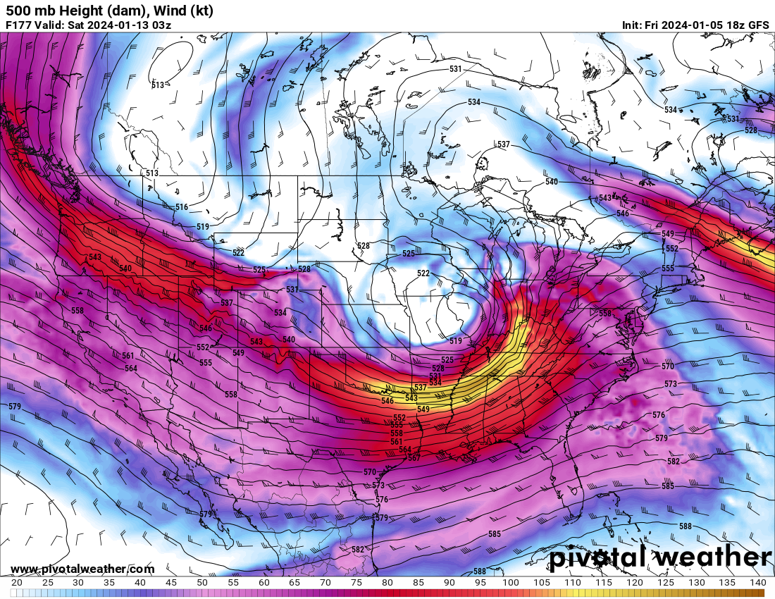
Sub 970 is just wild inside of 100 hours. When is the last time in winter this has even occurred?
-
1
-
-
28 minutes ago, Imneversatisfied said:
Pretty disappointing for me in Alpena too. Really need a SE shift. Starting to focus my attention on the weekend storm.
What has the total snowfall been up there this season? I’m up there sometimes for work (in the quarrying industry) and it’s usually a damn tundra this time of year
-
13 minutes ago, Stebo said:
We have a bunch of times lmao.
When was the last major one? Usually, not always these tend to go west
-
30 minutes ago, Stebo said:
Honestly we don't know the track yet, a few models have this coming straight north too. I would probably discount those models as its just very rare to get a track like that. Also you can get a situation like the Canadian where you get an attempt at a transfer which could pull the warm air away from the region as well. A lot of moving parts to this one including the small system in between that could lower heights as well ahead of this system.
To me it's starting to look like a classic Panhandle Hook, especially with that track. I can't think off the top of my head very many times we've cashed in on these systems, Chicago can though
-
1
-
-
Easy to forget because we've been tracking so long, but a SLP pressure in the 980s is plenty strong for this area. If low-mid 980s means more snow for more of the metro, easy choice.
Need the track to not be hard NNE from near STL to keep the dry slot and warmer temps aloft farther southeast. A slightly weaker system would help with that.
Bingo. It’s one thing that really jumps off the page to me with the guidance thru hour 144, these are some rather impressive SLP’s from a pure barometric standpoint.
What I’m curious about is why are we seeing such strength? Typically we see 995ish storms with 6-10” in its strongest swath, not very deep cyclones-
1
-
-
Wonder when the models will pick up on the dynamic cooling?
What is preventing this from moving SE again all?
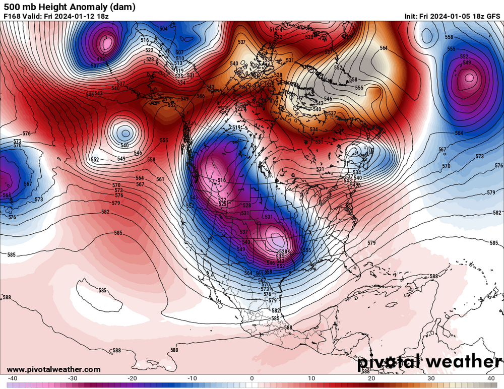
Why wouldn’t you expect it to trend NW over time? It’s a strong, deepening low that wants to go poleward. The sampling that has been done IMO has allowed the models to produce a more realistic solution.
I’m still concerned about the dry air intrusion in that second window, would not be shocked at all to see QPF impacted from the possible MDT risk event occurring in the Gulf Coast region -

Sheesh. The US-24 special here. This solution occurs, I’m stuck in my house for a week -
5 hours ago, andyhb said:
That would be rivaling the Blizzard of 1978 for the most severe on record in the Midwest. I say that with an entirely straight face.
I don’t recall if I’ve ever seen a 60+ mb gradient in my life quite like that. 1045 MB high in WCAN and a 970 MB low rushing through the GL is prolific. The thing that made ‘78 so special was that the arctic jet was basically brought down to the surface, wind gusts topped 100 mph over Lake Erie with sustained winds topping out at 80 in Cleveland
-
2
-
-
Just now, hawkeye_wx said:
It's probably safe to throw the early NAM runs in the trash. The global models are much farther south with the upper low.
I do think though pure climo is against anyone east of Chicago and Milwaukee getting a solid snow. This is a pretty damn strong low without anything to really keep it from cutting poleward as it bombs out
-
3 hours ago, andyhb said:
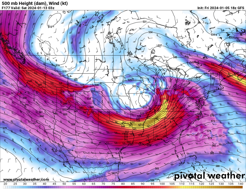
The 500 mb trough with that is... a spectacle, let's just say that.
As much as I’ve grown fond of warm, mild weather from years in the South, it’s been 5 years since I’ve seen a snowstorm of any kind. This would be cool to watch
-
Damn that's a beast of a storm, but the track is a tad unbelievable at the moment. Arkansas-Indy-Toledo on a storm bombing out? If it really enters the lower GL at around 975 MB then I'd expect more of a South Bend-Lansing low track
-
1
-
-
Heck of a system on there, not often you see sub 980 mb rolling thru the GL. Concerned about the severe side of things robbing this one of moisture on the backside, with the 540 line digging all the way to the GOM and FL I'd expect some serious convection on the southern end of this.
-
I cannot get over how little cold air there is on the backside of some pretty dynamic systems here in the upcoming days. Is it really that hard to get a high pressure on the backside of either of these events like normal to create a legitimate swath of snow?
-
You can tell the pattern is ready to flip in a thunderous way. Mid January should be rocking
-
23 minutes ago, Stebo said:
Looks like September
Unreal to see. Pretty nasty sea fog east of Toledo tonight. Perfect visibility here in Perrysburg, by the time I was around Oak Harbor stop lights were hard to see
-
Glad to see it still snows somewhere around here
-
48 minutes ago, Stevo6899 said:
Yea, it seems El Nino is definitely flexing its muscles, as it's been stormy down there this month. The last few winters it seemed like it would rain once a month down there, especially la nina winters. It's too bad when we get favorable la ninas, it seems the tele's wreak havoc and mess up a potentially good/snowy winter. I dont know much about them but id guess they are not affecting el nino or its tendencies so far this nov/dec.
That's how it was while I lived in Charleston. Played an unreal amount of golf through the winter months down there because of how dry it was, greens were excellent to put on
-
1
-
-
On 12/13/2023 at 12:24 PM, Stevo6899 said:
It's interesting that it's gonna be avg or slightly below avg temp wise down in sw Florida. Having lived there the past 4 winters, it's been normal for temps to be in the 80s for weeks in djf. It's just odd to see temps above avg in metro detroit, in mid/upper 40s, while at the same time it's barely cracking 70 down in south florida.
Quite a stormy pattern taking place down there, might even be able to go ENH tomorrow for Central FL. How often do you get 1040 MB highs in mid December with temps in low 50's here?
-
16 hours ago, hardypalmguy said:
Yep December was a torch outside of that mini outbreak of cold air. It hit 60 in Milwaukee before New Years.
Looks like this December is cooked. One of three winter months done. Two to go. Then the palms can come back out to play.
Picture of Milwaukee in 2060

-
 4
4
-


Winter '23-'24 Piss and Moan/Banter Thread
in Lakes/Ohio Valley
Posted
Tomorrow evening is when the picture becomes much clearer. Sampling occurs, the current system moves out and the NAM comes into play. Patience folks