

nwohweather
-
Posts
3,546 -
Joined
-
Last visited
Content Type
Profiles
Blogs
Forums
American Weather
Media Demo
Store
Gallery
Posts posted by nwohweather
-
-
Worst stretch of weather I’ve ever seen. 5 straight days of fog
-
10 minutes ago, IWXwx said:
@PowerballNope, it's for almost all advisories and all special weather statements. They will become "plain language headlines." Here is an overview of the changes:
Bad idea in my opinion. It’s more simple to know there’s a Winter Weather Advisory than issuing headlines
-
 1
1
-
-
Largest dense fog advisory in US history?

-
1
-
-
Might be time to change the avatar from the Heat Miser. Strong clippers and frozen ponds, Winter has actually arrived!
-
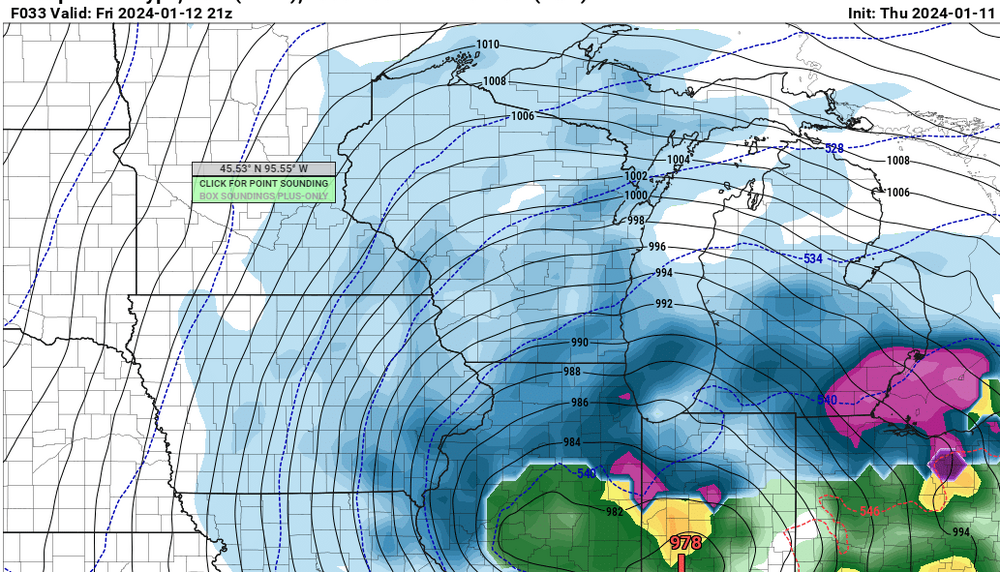
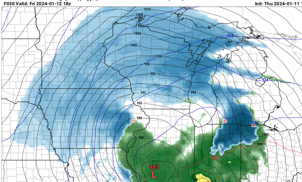
I almost think these two waves are being underplayed for the Toledo area. I think 2-4" with the energy rotating around the ULL tomorrow is a solid bet along the turnpike followed by 3-5" with such high snow ratios and a relatively strong clipper. May be best to put an advisory in place as 4-8" of fine powder over the course of 48 hours is going to be relatively impactful, especially from a blowing & drifting perspective
-
On 1/13/2024 at 6:26 PM, OHweather said:
To be fair, I hit send on this a little earlier than these posts:
URGENT - WINTER WEATHER MESSAGE
National Weather Service Cleveland OH
248 PM EST Fri Jan 12 2024

OHZ003-130000-
/O.NEW.KCLE.WW.Y.0002.240112T1948Z-240113T0000Z/
Lucas-
Including the city of Toledo
248 PM EST Fri Jan 12 2024

...WINTER WEATHER ADVISORY IN EFFECT UNTIL 7 PM EST THIS
EVENING...

* WHAT...Wet snow occurring. Additional snow accumulations of up
  to two inches.

* WHERE...Lucas county.

* WHEN...Until 7 PM EST this evening.

* IMPACTS...Plan on slippery road conditions.

* ADDITIONAL DETAILS...Heavy wet snow will impact travel
  conditions through the evening commute.
We were aware of the potential for an impactful burst of wet snow in the Toledo area, but yes the advisory came out later than would've been preferable. I had a bit of a gut feeling around 1 PM when TOL immediately dropped to 3/4 mile visibility in snow when precip came in...but since it was still 36-38 degrees across Lucas County, raining in Wood County south of the turnpike, and only sticking to grass in western Lucas County (not in the city of Toledo) I wasn't sure if it'd snow long enough to accumulate 2"+. I have no problem issuing an advisory for less than 4" of snow (our technical advisory criteria) based on impact, but there has to be a line somewhere and I don't want to do an advisory if I'm not confident it'll snow at least a couple inches. We issued a Special Wx Statement for up to 2" of quick snow accumulation and slick road conditions around 1:20. By 2:30 Findlay flipped to snow, precip rates were intensifying, and snow was sticking to roads in Lucas County. It was obvious that conditions would be poor through the evening commute and also that snow accumulations would be a good couple/few inches in western Lucas County, so we went with the advisory at that point.
Glad to see I had good instincts haha! 3 was good timing, it definitely was wild to see the weird cold air solution shown by the models actually play out in real life.
-
1
-
-
Accumulations definitely at 3” here and climbing. Such a slushy snow
-
4 minutes ago, Chinook said:
my place has had all snow
Where are you? I'm by the river in P-Burg/Waterville
-
21 minutes ago, Frog Town said:
31.8 here in Toledo with Heavy Snow and 2.5". Actually 10 miles NW of Toledo.
Very heavy here as well. A bit more wind driven as well.
10 minutes ago, sbnwx85 said:Mostly rain now. Waiting for dynamic cooling to switch everything back to snow.
Just read the IWX afd and it looks like they at least discussed a blizzard warning for Berrien County overnight but never outright say it.
One other area
of interest on winds will be mixing heights increasing and entering
Berrien County early Saturday morning, but low level winds look to
drop off there as the low level MSLP center moves through there. As
we couple the falling/already fallen snow across the area, there is
a chance that we see 35+ mph and visibility less than 1/2 mile in
these spots. The question will be, can we get 3 straight hours of
these conditions, which is fairly difficult around here. So, have
decided to put wording into the already existing headlines to
indicate that. Power outages with could occur with the pasty snow
and strong wind. With these conditions and the already
fallen/falling snow, N-S roadways will likely have blowing and
drifting tonight providing hazardous driving. The blowing and
drifting snow in addition to the increasing winds will also look
to decrease the visibility also making it a tough drive tonight
into Saturday morning.
That's brutal. Meanwhile off to the east it's pouring snow
-
Rippage

-
3
-
-
6 minutes ago, Frog Town said:
WWA posted for Toledo. A little late to the party
Man am I a genius or what?
-
 1
1
-
-
2 minutes ago, Frog Town said:
Crazy snow if Toledo with 2" already. Does anyone really know what's going on?? LOL>
NWS Cleveland needs to get WWA's up ASAP. The snow is far more entrenched along the lines of what the GFS showed than what they predicted. Tough call, but I think 3-4" is capable. It's definitely extremely wet, heavy snow
-
1
-
-
I think 2-4" for NW Ohio looks pretty reasonable...
At 119 PM EST, radar indicated wet snow moving north into the Toledo
metro area.

HAZARDS INCLUDE...
Visibility dropping to less than three quarters of a mile...
Up to 2 inches of quick snow accumulation through 5 PM...

Locations impacted include...
Toledo, Swanton, Perrysburg, Oregon, Sylvania, Rossford, Waterville,
Northwood, Whitehouse, Genoa, Holland, Maumee, Ottawa Hills,
Walbridge, Millbury, Haskins, Grand Rapids, Tontogany, Clay Center,
and Berkey.
Heavy, wet snow at the moment with visibilities below a quarter of a mile. I think that 2" amount will be exceeded in spots, especially west of Toledo
-
Absolutely ripping snow at my house SW of Toledo. Radar returns of rain are inaccurate
-
5
-
-
1 hour ago, Powerball said:
Was Jim Cantore also live on scene?
Yes
-
Lightning just caught on the weather channel live! That was awesome
-
The cold is ending up even more impressive than originally thought. From NWS Great Falls, for posterity. Forecast low tonight in Cut Bank, MT is -43...the forecast was in the -30s earlier today.
Area Forecast DiscussionNational Weather Service Great Falls MT837 PM MST Thu Jan 11 2024.SYNOPSIS...Snow continues to fall across the state through tomorrow morning.Extreme cold temperatures settle in for the weekend along withdangerous wind chills. Cold temperatures linger into next week.&&.UPDATE...With this evening`s forecast update, I lowered some of theovernight mountain temperatures a bit more than those included inour original forecast. Further, I increased relative humidityvalues, especially for southwest Montana. Only minor adjustmentswere made to wind speed/gusts values. No further updates arenecessary, at this time.- Fogleman&&.AVIATION...624 PM MST Thu Jan 11 2024 (12/00Z TAF Period)Note: The NWS Great Falls Weather Forecast Office manages thefollowing TAFs: KCTB, KHVR, KGTF, KLWT, KHLN, KBZN and KEKS.Winter weather impacts aviation during this 12/00Z TAF period,causing airfields to fall into MVFR/IFR/LIFR ranges, in snow and/orblowing snow or mist/freezing fog. Periods of gusty winds areforecast. Mountain obscuration continues for the duration of thisTAF period. Dangerously cold temperatures impact aviation ops, withsurface temperatures reaching as low as 35 below during this TAFperiod.- FoglemanRefer to weather.gov/zlc for more detailed regional aviation weatherand hazard information.&&.PREV DISCUSSION.../ISSUED 624 PM MST Thu Jan 11 2024/Rest of today through Friday morning...A surface low pressure issliding to the southeast along the western MT/ID border. Thearctic front is currently draped along the middle Gallatin Countyto southern Powell county corridor. Current radar shows widespreadlight snow across Western, Central, North Central MT. The snowshould slowly push southward along the arctic during theafternoon and evening. Southwest Montana should begin to seewidespread snow move in during the evening. Widespread snow willcontinue to fall across the CWA through tonight and into Fridaymorning. Snowfall across the lower elevations will remain on thelighter side. However, current radar and surface observations showthat there can be some moderate snow banding at times. Sinceliquid precipitation is low and snow ratios are high, total snowaccumulations remain low. Lower elevations are forecasted to seebetween 1-3" of snow. The heavier snow will fall along the lowerRocky Mountain Front and the Gates of the Mountains region wherethe Winter Storm Warning remains on track. As the arctic frontpushes south overnight into Friday morning, widespread snow shouldbegin to end north to south. Snow will push out of the mountainsand southwest Montana late Friday morning and clear out by Fridayafternoon.The main concern for the short term forecast this weekend is theextreme cold temperatures and dangerous to life threatening windchills. Temperatures will continue to steadily fall through Saturdaymorning. With winds sustaining between 15-20mph, dangerous windchills are the main impact. The Wind Chill Warning comes into aneffect this evening for Central and North Central Montana and WindChill advisories for Southwestern MT. Overnight lows Friday morningare expected to reach 20 to 35 below in Central and North CentralMT. -WilsonFriday through Sunday...A highly anomalous H500 trough andassociated Arctic airmass will bring dangerous, and potentially lifethreatening, cold temperatures and wind chills to all of NorthCentral, Central, and portions of Southwest Montana through theperiod. NAEFS return intervals for H850-700 temperatures are on theorder of 30 years to even outside of the climatological range. ECMWFEFI values with respect to both high and low temperatures are inexcess of 0.95 across all of Southwest through North CentralMontana, with a shift of tails of 0 to 1 across most of the NorthernRockies. This all translates into a highly impactful cold outbreakthrough the period; with the potential for not only new record lowminimum temperatures to be established at numerous climate site, butalso new record low maximum temperatures. Overnight lowtemperatures, particularly from Friday night through Saturdaymorning, have a 30-60% chance of exceeding 40 degrees below zeroacross the Golden Triangle (i.e. between Cut Bank, Havre, and GreatFalls). I would not be surprised if a couple of 50 degree below zeroreports occur over this timeframe and overall location given theforecasted surface high of ~1045mb to 1050mb expected to slide southalong the Canadian Rockies and over Northern Montana. Forecastedhigh temperatures over the timeframe are unlikely to exceed 10degrees below zero north of the I-90 corridor, with overnight lowsgenerally dipping into the 20 to 40 degree below zero range. I cannot emphasis how dangerous it will be to be outside for anyone whois not dressed properly or becomes stranded while traveling. Windchill values of 40 to nearly 70 degrees below zero are expectedexpected north of the I-90 corridor at times through Sunday, withthe coldest wind chills expected to occur from this evening throughSaturday morning. If you must travel, have an emergency kit for yourvehicle and keep the gas tank as full as possible. Even short tripscould become life threatening if your vehicle breaks down and youare unprepared. - Moldan
Ice fog levels of cold -
This keeps trending towards something more substantial for Toledo
-
1
-
-
I’m gonna go with 2-4” for everywhere west of I-75 with 1-2” east of it here in Toledo. I can’t imagine how bad conditions will be in the heart of this storm, absolutely paralyzing to get those winds with this level of snow
-
2 minutes ago, andyhb said:
Ope I see that title change.
Should’ve changed into January gale or white hurricane like the old newspaper articles
-
2 minutes ago, SchaumburgStormer said:
NAM doing NAM things
Unreal runs on the GFS...
Almost 24 hours out and it's showing 0" essentially on the Euro & 4-6" on the GFS for Toledo. This is insane
-
2
-
-
What in the world...

-
Pretty good agreement on the models here today. Can't say it any different, that's a historic blizzard for this weekend.
-
1
-
-
Yet another miss for Northeast Indiana upcoming, especially if the King reigns. More rain and the bad thing about this one is that it will be followed by a barren arctic tundra for days on end.
Tomorrow evening is when the picture becomes much clearer. Sampling occurs, the current system moves out and the NAM comes into play. Patience folks

Winter 2023/24 Medium/Long Range Discussion
in Lakes/Ohio Valley
Posted
Thank you! Chicago has about 20 90° days a year, how many places in the world can get both 95° temps in July and a yard of snow in the winter? Be thankful you get seasons at all