

nwohweather
-
Posts
3,548 -
Joined
-
Last visited
Content Type
Profiles
Blogs
Forums
American Weather
Media Demo
Store
Gallery
Posts posted by nwohweather
-
-
Omg what a beast!

-
I wouldn't mind a severe thunderstorm or two. It does stink that we haven't had really any severe weather to track around here
-

Robust hooks already showing on radar.
Overcrowding looks like it may keep a lid on todays activity. Good setup but if everything is firing then they’re all fighting for the same instability -
8.4C/km at New Orleans this morning:
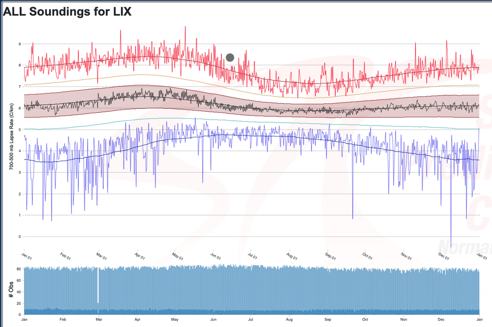
Wild to see. Living in the SE for a few years it was nuts to see the vertical look of the pop up storms compared to what we have the in the Midwest -
Just insane lapse rates, I don't think I've ever seen them this high in the Southeast. Add in that it's mid June and holy smokes this is anomalous
-
 1
1
-
-
.4" at the house. Talk about a drought buster

-
Insane how hard the precip has to fight to reach the surface. A derecho type event would be clutch right now
-
1
-
-
2 hours ago, SolidIcewx said:
Reports of smoke smell in St Claire, Macomb, and Oakland counties. Fires in Quebec and one in particular in Ontario NW of Manitoulin island have expanded quite a bit. Curious to see the GOES satellite images tomorrow morning
I should have named this the Smoke & Drought thread
-
18 hours ago, Stebo said:
I hope you are hit with water restrictions. Talk about an arrogant yard.
Dude we live by Great Lakes, it’ll be okay this isn’t Phoenix. Wasn’t that long ago they were full to the brim
-
1
-
-
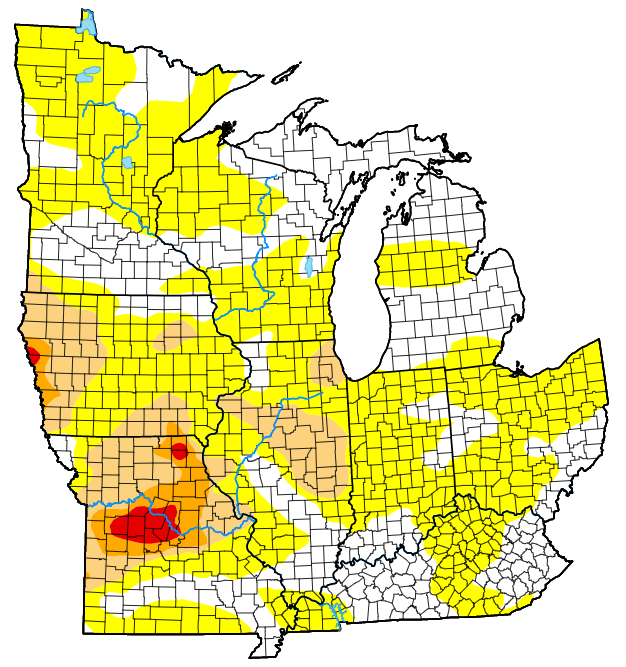
FYI I started a drought thread. It's been pretty remarkable to see and I appreciate @SolidIcewx's comments about the wildfire danger. I would not be shocked to see brush fires or even forest fires take place with this extreme heat, lack of humidity & breezy conditions.
-
 1
1
-
-
I figured I'd start the conversation here. My house has only a seen little bit of rain last on May 19th. It looks like we could reasonably make a run at nearly a month between rain drops which is something I personally have never seen in this region. Also current conditions at my house are 90° with a dewpoint of 42° which is another insane statistic.
-
Damn dust bowl out there
-
What a beautiful day. Actually in Toronto on business this week, absolutely no complaints with this weather. Tremendous city as well, it may be my favorite in North America (between that and Boston).
-
1
-
-
On 5/3/2023 at 11:16 AM, A-L-E-K said:
lol dirt roads
little house on the prairie shit
It's the oddest thing about Michigan. You have legitimately nice neighborhoods in SE Michigan connected by gravel roads. Ohio in very rural places can have extremely narrow roads, but they're always paved
-
1
-
-
19 hours ago, Stebo said:
The term heat lightning is commonly used to describe lightning from a distant thunderstorm just too far away to see the actual cloud-to-ground flash or to hear the accompanying thunder.
Thanks for proving my point for me.
How much of an ass can you be? Sheesh man, of course that’s what it is, he even admitted that the storms were far off. If anything it’s something that usually occurs during warmer seasons only where you get the truly towering thunderstorms. Awesome to see while flying at night to be honest
-
1
-
2
-
-
Definitely a rainy start to May coming up
-
A good bit of CIN in place I think keeping a lid on things. Energy, shear and helicity are all through the roof. All could easily support a violent tornado, we’ll see if the Emporia one could break thru
-
Storm south of OKC is cycling. Also holy cow that cell west Emporia has that look

-
Shocked this thread isn’t exploding. That was a big tornado heading into OKC
-
To the supposed lack of EF-5s since Moore, if EF-5 were adjusted down to 190+ mph, we'd have seen the "normal" amount of EF-5s over the past 10 years. Particularly with that DI and DOD for houses.
As an NWS employee, I think that the agency as a whole has lost the plot when it comes to damage ratings. Having some reference to engineering standards is all well and good, but an impossible standard to reach EF-5 has been set based off building codes that don't exist in much of the country.
We've become fixated on finding everything a tornado didn't do as opposed to judging what a tornado did do with respect to totality of damage. If a large swath of a town has catastrophic destruction, it's not the town's fault if they don't have structures built to withstand >200 mph winds. The lower bound on the DIs is used too liberally imo.
Vilonia is an example less than a year after Moore of a tornado that by all accounts should have been rated EF-5. Prior to that, there's a good case to be made that Tuscaloosa 2011 should have been EF-5. On the flipside of that, it seems likely that the post-Moore survey standards would have yielded at least a few less EF-5s on April 27, 2011.
In recent years, I think Mayflower is probably the best example of how the pendulum has swung well too far in the direction of assigning impossible engineering standards to reach EF-5.
Hopefully, the forthcoming updates to the EF scale help bring things back to a more reasonable/realistic place.
Really well said. Vilonia and Mayfield are two obvious situations of a likely EF5 in my opinion. Mayfield probably had the most airborne debris signatures I’ve ever seen, and a track of almost 200 miles. How a mesocyclone that sustaining wasn’t an EF5 is beyond me-
1
-
-
Just incredible weather, loving every bit of this before the front comes through. It's doing wonders for fishing around here with some anglers hitting walleye limits in 45 minutes
-
7 minutes ago, SchaumburgStormer said:
That Peoria sup is a beast.
Definitely fading as a tornadic cell. Can only fight your environment for so long
-
9 minutes ago, DaveNay said:
@andyhb just said conditions are favorable for this cell to to continue on towards Peoria/Washington.
Is it? A good bit of CIN and a higher LCL as it approaches Peoria, although the local environment has very high SRH
-
Of course this is the time I have work trip in Maryland. On a peak chase day tomorrow for the Lower GL
June 2023 General Discussion
in Lakes/Ohio Valley
Posted
I took a video of it (currently in Oak Harbor). Pretty harsh rotation there