

paweather
-
Posts
10,280 -
Joined
-
Last visited
Content Type
Profiles
Blogs
Forums
American Weather
Media Demo
Store
Gallery
Posts posted by paweather
-
-
2 minutes ago, Bubbler86 said:
But the 6Z Euro is warm. At hour 90, some of the LSV is mixed. Nothing like the GFS which is my point of the gyrations with the models.
Understood for the heart of the LSV we are good. But yes some mixing SE for sure.
-
 1
1
-
-
2 minutes ago, Bubbler86 said:
It is uncanny how up and down the tracking has been on this one. It seems every 12 hours we have one suite threatening a little snow/a sunny day on Saturday and another driving a low too far north. Goes to show how hard trying to put a forecast out is...the interactions are too complicated to pin down.
Blizz shared the EURO it only goes out to 90 after that it dumps.
-
1 hour ago, Blizzard of 93 said:
0z Euro crushes vast majority of CTP with 8 to 12 of snow. Great low track for us & precip amounts increased again.


Good runs Blizz!
-
1
-
-
Just now, CarlislePaWx said:

Hit’em!!!
-
11 minutes ago, mitchnick said:
Icon complete on tt. Big hit
Hit’’em!
-
18 minutes ago, MAG5035 said:
Could be a couple of things. I won’t put words in anyone’s mouth but here’s my objective thoughts on some of the cons of this setup.
Precip issues are still possible in the southern tier even with these lower QPF/progressive solutions depending on the thermals.. something we won’t have a firm handle of till we’re in range of the high res guidance. I do think we’ll see mostly snow in here from this, but the possibility of some mixing in the southern tier still exists. We’ve changed the pattern around to where it’s cold enough and we have a high available for this system, but it’s still not significantly cold here.. just cold that’s average.
The 500mb pattern out west is not typically what you would see for a C-PA snowstorm. We’re always looking for the big western ridge and associated amplification to run a coastal storm all the way up the coast and we have the complete opposite with the -PNA setting up and a big western trough. What makes this work is having some downstream blocking and 50/50 low allowing this shortwave that kicks out from the southwest go underneath us. What’s being pointed out by some is these weaker solutions late today along with being faster come from more energy dumping into the southwestern trough (which eventually becomes our next headache next week) making for a weaker shortwave (that becomes our weekend storm) that kicks out. That kind of evolution takes away the top end potential. This is still probably a half decent event but not a blockbuster 1-2 foot type thing. More of 4-8” kind of event is what I’m thinking right now for the swath of heaviest snow… which I think about anyone in here would be happy with.
Makes sense thanks Mag
-
18 minutes ago, Itstrainingtime said:
So you're saying that Elliott, who is a great met, is totally wrong when he said that the models do NOT fit the pattern?
What is meant by fits the pattern?
-
1 minute ago, Blizzard of 93 said:
Yep forget model worries
-
2 minutes ago, Bubbler86 said:
The 18gfs was great news for the Southern pa counties. So we're most of the GEFS members.
Does that include Lebanon county? LOL
-
6 minutes ago, Itstrainingtime said:
MU finally said something about the weekend: "snow lovers should keep expectations in check"
Also indicated that the pattern does NOT match the model outputs.
Detailed analysis tomorrow.
Expectations being plowable check.
-
 1
1
-
-
Yes @Bubbler86it is going to burn me I’m sure but I gotta try everything to get a plowable snow!

-
@Blizzard of 93needs some help with this model worries stuff! We been there done that over the years all the time
-
1
-
-
25 minutes ago, Itstrainingtime said:
12z and 18z GFS couldn't be much more different. Maybe some people "get" the same amount of snow, but the storm's evolution is vastly different. And different in a positive way for us SE folks.
Yep still same here
-
9 minutes ago, Bubbler86 said:
I hope you are joking. LOL.
Check out this compare from 12 to 18Z. 12 has a dying primary/ULL in Ohio. 18 has little precip in far SW PA because there was little prescence in the Oh Valley. Weaker and faster low.


All in all the kuch range for my area has not changed that much.
-
1
-
-
1 minute ago, Superstorm said:
Good run
.Yep fairly consistent!
-
CTP:
The operational GFS, ECMWF, and Canadian models continue to
show a similar story - isentropic ascent ahead of the storm
system moving into the region by Saturday morning and becoming
most vigorous by Sat afternoon into early Sat evening. By 00z
Sunday, the dominant forcing transitions from isentropic ascent
to fgen banding on the back side of the low, within a paired
right entrance / left exit region of the upper jet. This
scenario would result in several inches of snow across central
PA. However, it is worth noting that there are still some
ensemble members that keep most of the precip to the east,
resulting in little to no snow accumulation for central PA. The
range of possibilities shown by the NBM 10th and 90th
percentiles ranges from a coating to 1 inch in the best case to
over 1 foot of snow in some spots in the worst case scenario.

There will be a period of dry weather later Sunday through
Monday night before the next storm system approaches late Monday
night. This storm looks to be stronger than the weekend storm,
but also has the potential to track to our west, ultimately
putting is in the warm sector after a period of cold air
damming. In that case, there could be a several hour period of
snow before a mix with and changeover to rain. However, it is
much too early for details, as there is plenty of time for the
track of this system to change. The presence of cold air ahead
of this system will also depend and how much snowpack is left
behind from the weekend storm.
-
1 minute ago, Bubbler86 said:
I have to do something to counteract the silly comments I get about not using guidance past a certain hour....this after watching the big boys flip and flop today.
Lots of flip and flops today but that is all the time. I am still liking the chances of a quick 4-8" type storm. Power El Nino like.

-
1
-
-
9 minutes ago, Bubbler86 said:
NAM AT RANGE WARNING----NAM AT RANGE WARNING
At 84 hours the SLP is on the cusp of the Gulf near New Orleans in a very similar position as the 12Z CMC. The approaching High is displaced a bit East vs, the CMC. Looking at 500H it is going to go North East in some manner but would be guess work to suggest how.
NAM at range warning. You serious? LOL.
-
27 minutes ago, canderson said:
I was not ok last night …
Better than State College even a 12 team playoff we will likely be out of with Franklin our coach.
-
1
-
-
14 minutes ago, MAG5035 said:
To further on the 12z Euro EPS
3”+ probs
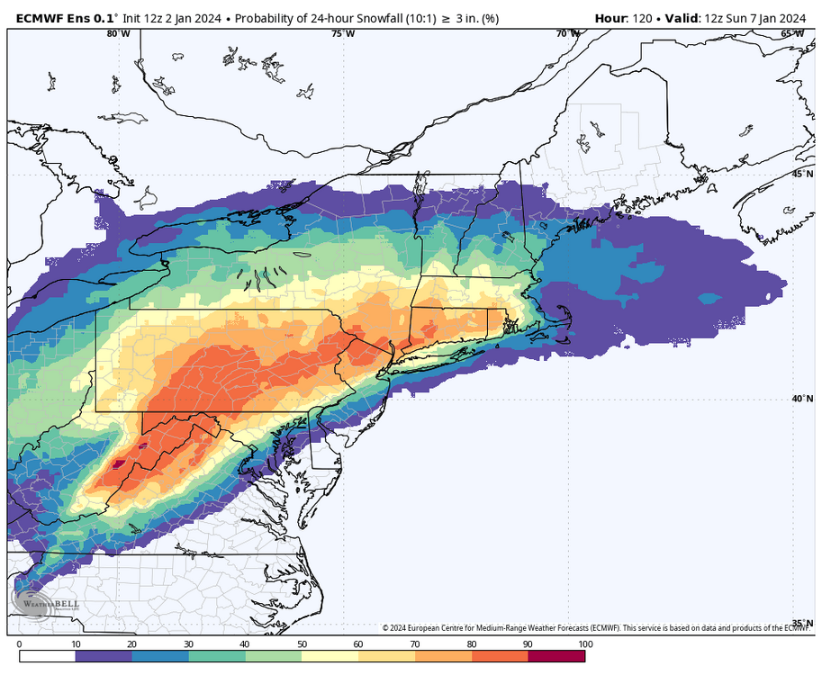
6+ probs
Maybe
Edit to note that the 12”+ probs are completely non-existent (no ensemble member showing 12+), so the ensemble overall has definitely picked up on the faster motion of this storm.
Maybe more like a 3-6 4-8 storm for us. Outside of this one model run. 18z up in the next couple of hours.
-
3 minutes ago, mitchnick said:
Geps a whole lot better than 0z run
.thumb.png.33d364369fbf75543617a26a60ae4a8f.png)
A PA Plower.
-
1
-
1
-
-
Tough Loss @candersonI was rooting for them.
-
 1
1
-
-
6 minutes ago, Blizzard of 93 said:
Low is in a great spot, just need to slow it down a bit & ramp the precip back up.
4 days to go, but I would be good with a region wide 5 to 10 of snow.


Let's do this one Blizz.
-
1 minute ago, Bubbler86 said:
Parts of the MA lost over 1/2 foot.
Yep this is really becoming a PA snowstorm. Intense and quick.


.png.ef1045fbcb6d0cb8b20536e931d0e977.png)


Central PA Winter 23/24
in Upstate New York/Pennsylvania
Posted
NAM at 70 plus is never to take.