

paweather
-
Posts
10,309 -
Joined
-
Last visited
Content Type
Profiles
Blogs
Forums
American Weather
Media Demo
Store
Gallery
Posts posted by paweather
-
-
11 minutes ago, Blizzard of 93 said:
In summary…. Let’s do this!!!
We have our first nearly region wide Winter storm Watch in 2 or 3 years…
I’m stoked!
Agree!
-
3 minutes ago, canderson said:
@Atomixwx you still with us? No word today which makes some super sad.
I think he got banned could be wrong hope I am.
-
 1
1
-
 1
1
-
-
4 minutes ago, Superstorm said:
3K NAM is a beaut
.Calling the snow Armageddon
-
10 minutes ago, mitchnick said:
Dang Eps!
.thumb.png.a9139b78359c2160c8e210bbbd18a527.png)
I’m ready to snowblow!!
-
 1
1
-
-
3 minutes ago, Blizzard of 93 said:
I’ll take his 3 to 6 of snow & like it!
Yep sign me up!
-
 1
1
-
-
32 minutes ago, canderson said:
ABC’s 27 forecast
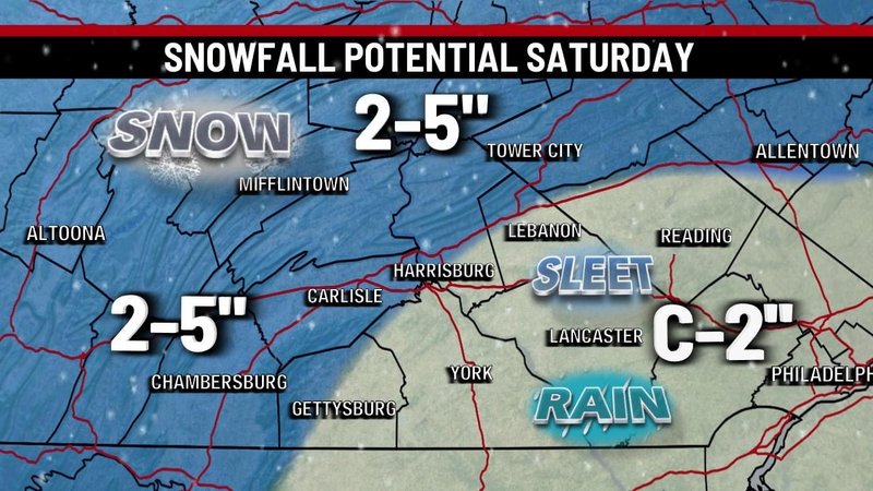
Local News war WGAL is 2-5
-
6 minutes ago, Bubbler86 said:

Not bad.
-
 1
1
-
-
My last call:
Harrisburg, Lebanon, and surrounding areas 3-5"
Lancaster York areas 2-3"
Palmyra - 1.2”
Last call only one call for me.


Fixed lol
That is about right! LOL.
-
My last call:
Harrisburg, Lebanon, and surrounding areas 3-5"
Lancaster York areas 2-3"
Palmyra - 12"
Last call only one call for me.
-
2
-
1
-
 1
1
-
-
2 minutes ago, mitchnick said:
All downhill from there unfortunately
I stay all snow just the back side of the storm. 10pm on.
-
Dumping:

-
2 minutes ago, Superstorm said:

12Z
.Like it!
-
3 minutes ago, pasnownut said:
Do you like WB? I had it for a while many moons ago, and considered getting it again.
Its OK. i only paid for the month will likely pay 1 more month for it.
-
1
-
-
JB still 3-6, 6-12 NW areas.
-
2 minutes ago, Bubbler86 said:
As depicted, that is a much more interesting situation than next week. That is definitely a period to watch.
Yeah agree just doing model observations.
-
1
-
-
Another rainstorm next weekend.
-
1 minute ago, Bubbler86 said:
We may have been expecting too much with marginal cold and a low in the midwest.
Yeah was hoping for some front end love and no it is a rainstorm through and through.
-
1
-
-
Gullywasher:

-
Good hit on the GFS:

-
See if the RGEM holds.
-
2 minutes ago, mitchnick said:
I'll take the Nam. I think we get a second batch from the trailing vort. Probably no accumulations however.
Yes, it looks like a second batch for sure maybe squeeze out another inch.
-
1 minute ago, Bubbler86 said:
Very convoluted. The pressure panels show it carrying two lows for several panels and neither really strengthens much. 850's are lost well into PA Sat morning but come crashing back as the Tn/Oh Valley Prescence lose impact. So it started as a Miller A but really went off the tracks.
Yeah in the end nice 4-6" snow before dryslot and/or light mix.
-
-
2 minutes ago, Bubbler86 said:
At 57 the OH Valley Primary, which was the new low spawned a few panels before, is totally ceding to the coastal but the coastal only down to 1005.
That is better cold air stays drawn in. I like this run.
.png.a20133be9659320c4ed668ab091be4d6.png)


Central PA Winter 23/24
in Upstate New York/Pennsylvania
Posted
CTP got me back for the 4-7 with rain added in.